
By 10 p.m. on October 6, the storm moved west-northwest at a speed of about 20km/h; in the northern mountainous area, it weakened into a low pressure area with an intensity below level 6. The affected areas are the northern Gulf of Tonkin, the coastal mainland area from Quang Ninh to Hung Yen, Lang Son province, the northeast of Bac Ninh province, and the east of Cao Bang province. Disaster risk level: Level 3.
At sea: Northern area of Bac Bo Gulf (including Bach Long Vi, Van Don, Co To, Cat Hai and Hon Dau island) strong winds level 7-9, near the storm center level 10-12, gust level 14, waves 2-4m high, near the storm center 3-5m, rough seas (very dangerous for ships).
Coastal areas and islands in Quang Ninh - Hai Phong provinces have storm surges of 0.4-0.6m. Beware of flooding in low-lying coastal areas and river mouths due to surges and big waves in the early morning of October 6.
Warning: The weather at sea and in coastal areas during the storm is extremely dangerous and unsafe for any vehicle or structure operating in the danger zone such as: cruise ships, passenger ships, transport ships, cages, rafts, aquaculture areas, dykes, embankments, coastal routes. Vehicles are at high risk of capsize, destruction, and flooding due to strong winds, big waves, and rising sea levels.
On land: From the night of October 5 to noon on October 6, on land in coastal areas from Quang Ninh to Hung Yen and Lang Son province, winds will gradually increase to level 6-7, near the storm center, level 8-9, gusting to level 11-12 (winds can break tree branches, blow off roofs, causing damage to houses, making it impossible to go against the wind). Inland areas in the Northeast, winds will increase to level 4-5, in some places to level 6, gusting to level 7-8.
Communes and wards in the northeastern region of Quang Ninh province are likely to have strong winds of level 8-9, gusting to level 11-12; the remaining communes and wards of Quang Ninh province and the coastal area of Hai Phong are likely to have strong winds of level 7-8, gusting to level 10; the coastal communes and wards of Hung Yen province and the northern border communes of Lang Son province are likely to have strong winds of level 6-7, gusting to level 9; the northeastern region of Bac Ninh province (formerly Bac Giang province) and the eastern region of Cao Bang province are likely to have strong winds of level 6, gusting to level 8.
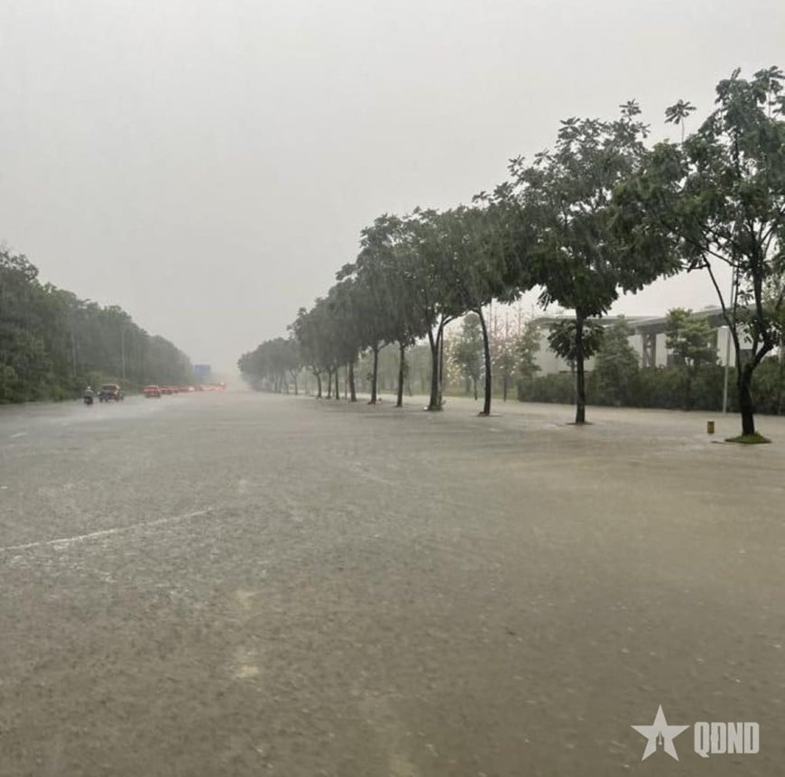
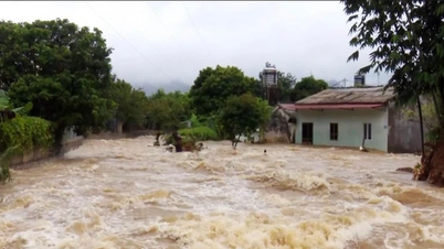
In addition, from the night of October 5 to the end of the night of October 7, in the mountainous and midland areas of the North, there will be heavy rain, with rainfall ranging from 150-250mm, and locally very heavy rain over 400mm. Warning of the risk of heavy rain (over 150mm/3 hours); in the Northern Delta and Thanh Hoa, there will be moderate to heavy rain with rainfall ranging from 70-150mm, and locally very heavy rain over 200mm.
Hanoi area is less likely to be affected by storms, need to be on guard against thunderstorms, tornadoes and strong gusts. Forecast from early morning October 6 to the end of October 7, there will be moderate to heavy rain, with common rainfall of 70-120mm, locally over 150mm.
Weather forecast for regions across the country today (October 6):
Northwest: Heavy rain during the day, locally very heavy rain in some places; light wind; thunderstorms with possibility of tornadoes, lightning and strong gusts of wind; temperature 25-30 degrees Celsius
Northeast: Cloudy, heavy rain, locally very heavy rain; especially in the plains and Thanh Hoa, there will be moderate rain, heavy rain and thunderstorms, locally very heavy rain; Northwest to North wind level 4-5, some places level 6, gusting to level 7-8; especially from Quang Ninh to Hung Yen and Lang Son, strong wind level 6-7, gusting to level 8-9, coastal areas level 8-10, gusting to level 11-12; in thunderstorms, there is a possibility of tornadoes, lightning and strong gusts; temperature 26-29 degrees Celsius
Hanoi Capital: Cloudy, with moderate to heavy rain and scattered thunderstorms, locally very heavy rain; Northwest to North wind level 4; thunderstorms with possibility of tornadoes, lightning, hail and strong gusts of wind; temperature 24-29 degrees Celsius.
From Thanh Hoa to Hue: Cloudy, scattered showers and thunderstorms; West to Southwest wind level 2-3; in thunderstorms there is a possibility of tornadoes, lightning and strong gusts; temperature 25-34 degrees Celsius
South Central Coast: Cloudy, scattered showers and thunderstorms; Southwest wind level 2-3; thunderstorms with possibility of tornadoes, lightning and strong gusts; temperature 24-34 degrees Celsius
Central Highlands: Cloudy, with scattered showers and thunderstorms in some places, especially in the late afternoon and evening with scattered showers and thunderstorms in some places; Southwest wind level 2-3; in thunderstorms there is a possibility of tornadoes, lightning and strong gusts of wind; temperature 23-30 degrees Celsius
Southern region: Cloudy, with scattered showers and thunderstorms in some places, especially in the late afternoon and evening with scattered showers and thunderstorms in some places; Southwest wind level 2-3; in thunderstorms there is a possibility of tornadoes, lightning and strong gusts of wind; temperature 24-34 degrees Celsius
Hoang Sa special economic zone (Da Nang): Scattered showers and thunderstorms; in thunderstorms there is a possibility of tornadoes and strong gusts of wind level 6-7; visibility is over 10km, decreasing to 4-10km in the rain; South to Southeast wind level 4-5; high waves 2-4.
Truong Sa special economic zone (Khanh Hoa): Showers and thunderstorms in some places; visibility over 10km; southwest wind level 3-4; waves 1.5-2.5m high.
Source: https://baolangson.vn/thoi-tiet-hom-nay-6-10-bao-so-11-gay-mua-lon-o-bac-bo-5060928.html

![[Photo] Closing of the 13th Conference of the 13th Party Central Committee](https://vphoto.vietnam.vn/thumb/1200x675/vietnam/resource/IMAGE/2025/10/08/1759893763535_ndo_br_a3-bnd-2504-jpg.webp)


Comment (0)