
 |
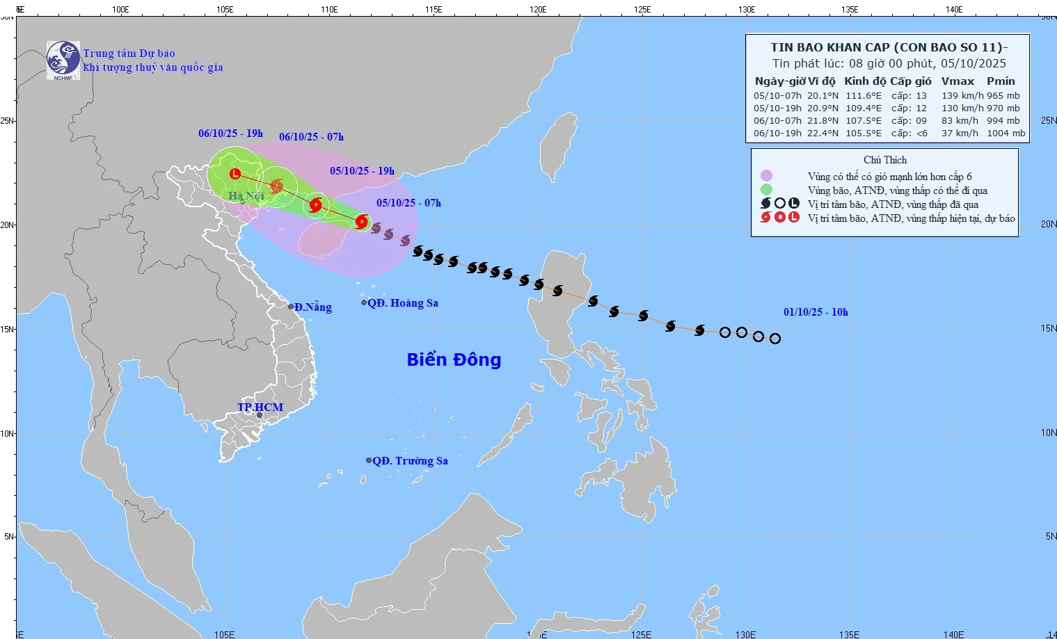
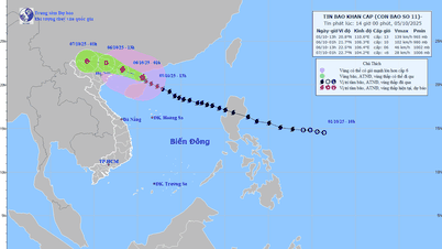
| Forecast map of the trajectory and intensity of storm No. 11 issued at 8:00 a.m. on October 5, 2025. (Source: National Center for Hydro-Meteorological Forecasting) |
📍 Storm forecast for the next 24 to 36 hours
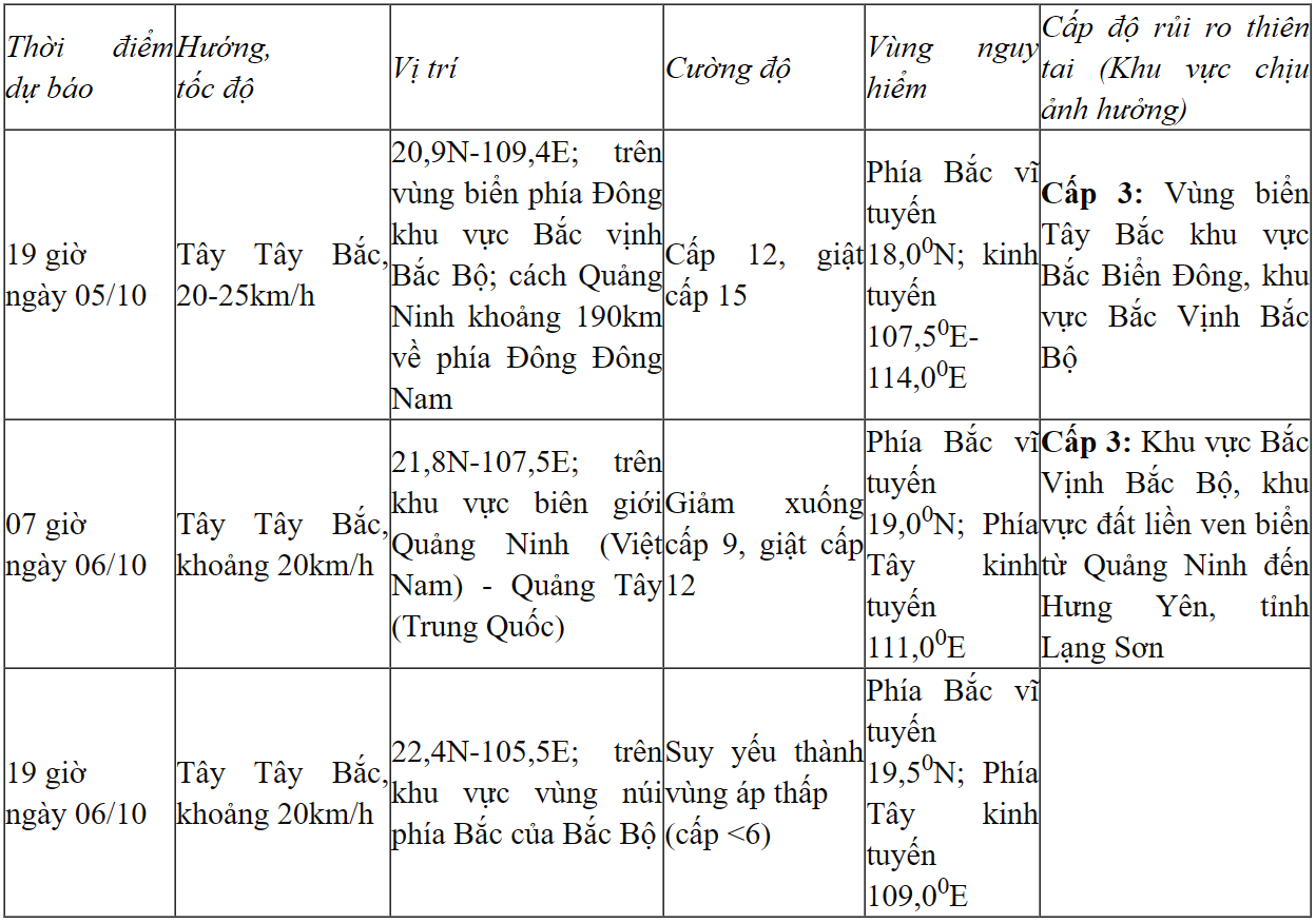 |
📍 Forecasting the impact of storms
📍 Forecast of storm impact on Tuyen Quang province:
Heavy rain: On the night of October 5, there will be scattered showers and thunderstorms in some areas; from the morning of October 6 to the end of the night of October 7, there will be heavy to very heavy rain and scattered thunderstorms in Tuyen Quang province. Rainfall is generally from 100-200mm/period, in some places over 300mm/period. Warning of heavy rain (>100mm/3 hours). Thunderstorms, tornadoes: Due to the influence of the wide storm circulation, it is necessary to be on guard against the risk of thunderstorms, tornadoes, lightning and strong gusts of wind both before and during the storm's landfall.
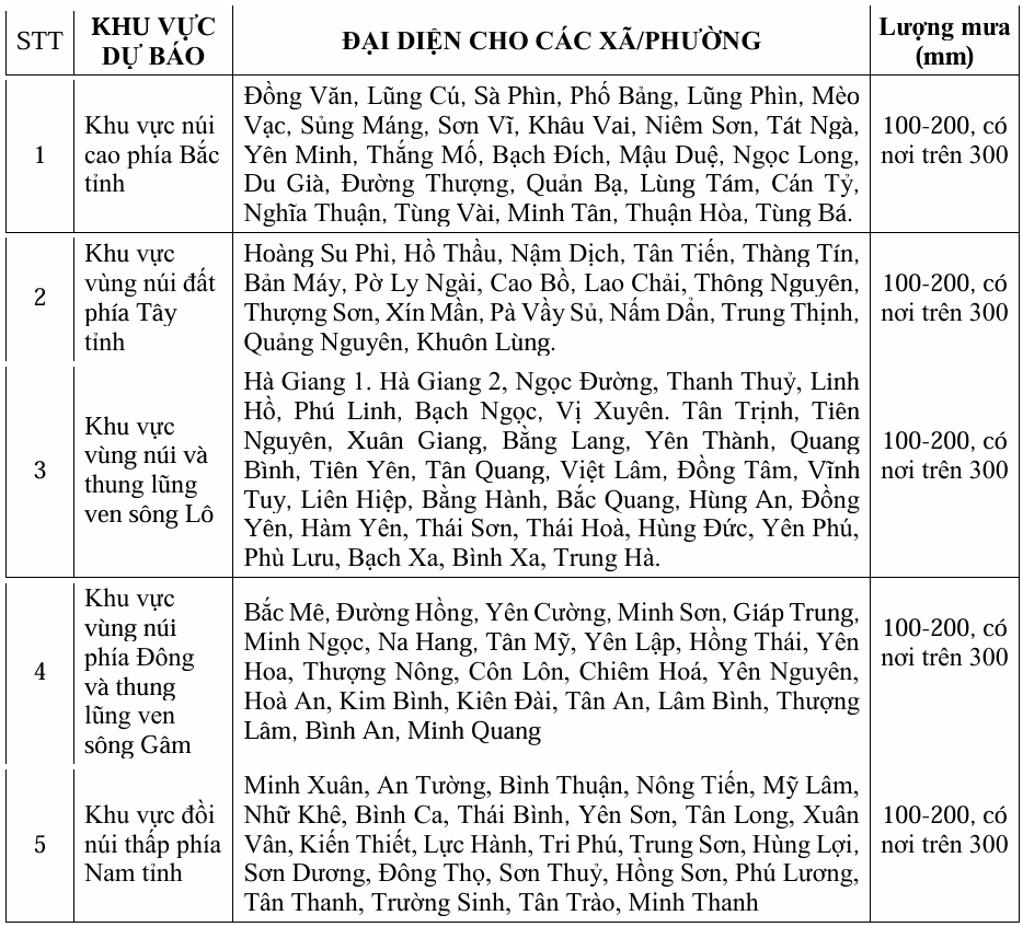 |
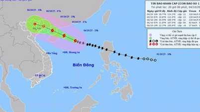
| Heavy rain forecast in localities in Tuyen Quang province. |
Strong winds, big waves, rising water
At sea:
- The Northwestern sea area of the North East Sea has strong winds of level 8-10, the area near the storm center has winds of level 11-13, gusts of level 15-16, waves 4.0-6.0m high, the area near the storm center is 6.0-8.0m, the sea is very rough ( extremely destructive, extremely strong waves. Sinking large tonnage ships ) .
- From the afternoon of October 5, the sea area to the east of the Northern Gulf of Tonkin (including Bach Long Vi special zone) has winds gradually increasing to level 6-7, then increasing to level 8-9. From the evening of October 5, the Northern Gulf of Tonkin area (including Bach Long Vi special zone, Van Don, Co To, Cat Hai and Hon Dau island) has winds gradually increasing to level 8-10, waves 2.0-4.0m high, the area near the storm center has levels 11-12, gusts of level 15, waves 3.0-5.0m high, rough seas ( very dangerous for ships ) .Rising water and coastal flooding: Coastal areas and islands in Quang Ninh - Hai Phong provinces have storm surges of 0.4-0.6m high. Beware of flooding in low-lying coastal areas and river mouths due to rising water and big waves from the afternoon and evening of October 5.
⚠️ Warning: The weather at sea and in coastal areas during the storm is extremely dangerous, unsafe for any vehicle or structure operating in the danger zone such as: cruise ships, passenger ships, transport ships, cages, rafts, aquaculture areas, dykes, embankments, coastal routes. Vehicles are at high risk of capsize, destruction; flooding due to strong winds, big waves and rising sea levels.
On land:
- From the night of October 5 to noon of October 6, on the mainland in coastal areas from Quang Ninh to Hung Yen and Lang Son province, winds gradually increase to level 6-7, near the storm center, level 8-10, gusting to level 11-12. ( The wind breaks tree branches, blows off roofs, causing damage to houses. It is impossible to go against the wind .) Inland areas in the Northeast have strong winds of level 4-5, in some places level 6, gusting to level 7-8.
- The communes/wards in the northeastern region of Quang Ninh province are likely to have strong storm winds of level 9-10, gusting to level 12-13; the remaining communes/wards of Quang Ninh province and coastal areas of Hai Phong city are likely to have strong storm winds of level 8-9, gusting to level 10-11; the coastal communes/wards of Hung Yen province and the northern border communes of Lang Son province are likely to have strong storm winds of level 6-8, gusting to level 9-10; the northeastern region of Bac Ninh province (formerly Bac Giang province) is likely to have strong storm winds of level 6-7, gusting to level 8-9.
📍 Heavy rain:
- From the night of October 5 to the end of the night of October 7, in the mountainous and midland areas of the North, there will be heavy rain, with average rainfall of 150-250mm, and locally very heavy rain over 400mm. Warning of the risk of heavy rain (>150mm/3 hours); in the Northern Delta and Thanh Hoa, there will be moderate to heavy rain with average rainfall of 70-150mm, and locally very heavy rain over 200mm.
- Hanoi area: Less likely to be affected by storms, need to be on guard against thunderstorms, tornadoes and strong gusts. Forecast from early morning of October 6 to the end of October 7, there will be moderate to heavy rain, with common rainfall of 70-120mm, locally over 150mm.
Thunderstorms, tornadoes
Due to the influence of the wide storm circulation, it is necessary to guard against the risk of thunderstorms, tornadoes and strong gusts of wind both before and during the storm's landfall.
According to nchmf.gov.vn
Source: https://baotuyenquang.com.vn/xa-hoi/202510/tin-bao-khan-cap-con-bao-so-11-21314f3/

![[Photo] Prime Minister Pham Minh Chinh chairs the Government's online conference with localities](https://vphoto.vietnam.vn/thumb/1200x675/vietnam/resource/IMAGE/2025/10/5/264793cfb4404c63a701d235ff43e1bd)


![[Photo] Prime Minister Pham Minh Chinh launched a peak emulation campaign to achieve achievements in celebration of the 14th National Party Congress](https://vphoto.vietnam.vn/thumb/1200x675/vietnam/resource/IMAGE/2025/10/5/8869ec5cdbc740f58fbf2ae73f065076)


![[VIDEO] Summary of Petrovietnam's 50th Anniversary Ceremony](https://vphoto.vietnam.vn/thumb/402x226/vietnam/resource/IMAGE/2025/10/4/abe133bdb8114793a16d4fe3e5bd0f12)

![[VIDEO] GENERAL SECRETARY TO LAM AWARDS PETROVIETNAM 8 GOLDEN WORDS: "PIONEER - EXCELLENT - SUSTAINABLE - GLOBAL"](https://vphoto.vietnam.vn/thumb/402x226/vietnam/resource/IMAGE/2025/7/23/c2fdb48863e846cfa9fb8e6ea9cf44e7)


Comment (0)