
Mr. Huong said that in the next 24-48 hours, due to the storm interacting with cold air, the intensity of storm No. 4 will continue to weaken and is likely to weaken into a low pressure area before moving into the Gulf of Tonkin.
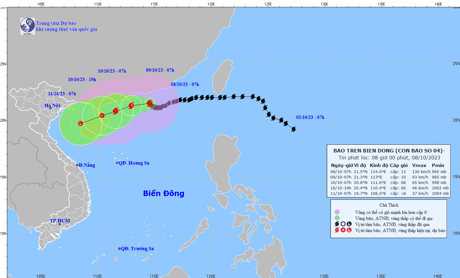
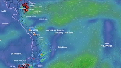
At 7:00 a.m. on October 8, storm No. 4 was about 100km south of Hong Kong (China). The strongest wind near the storm's center was level 12 (118-133km/h), gusting to level 15, moving slowly in a West-Northwest direction at a speed of about 5km/h.
The National Center for Hydro-Meteorological Forecasting said that in the next 24 hours (from 7:00 a.m. on October 8), the storm will move westward at a speed of about 5 km per hour and gradually weaken. At 7:00 a.m. on October 9, the center of the storm will be about 280 km east of Leizhou Peninsula (China) with a strong intensity of level 10, gusting to level 13.
During the next 48 hours, the storm changed direction to West Southwest, moving about 5 km per hour and continued to weaken. At 7:00 a.m. on October 10, the center of the storm was about 110 km east of Leizhou Peninsula (China) with a level 8 intensity, gusting to level 11.
In the next 72 hours, the storm changed direction to the southwest, moving about 10km per hour and weakened into a tropical depression, then continued to weaken into a low pressure area. At 7am on October 11, the center of the low pressure was over the sea west of Hainan Island (China) with an intensity of less than level 6.
In the next 24 to 48 hours, the northern sea area of the North East Sea will have strong winds of level 7-9, the area near the eye of the storm will have strong winds of level 10-12, gusting to level 14; the sea will be rough. All vessels operating in this area will be affected by strong storm winds. The northern sea area will have waves of 2-4m high, the northern sea area will have waves of 4-6m high, the area near the eye of the storm will have waves of 6-8m high.
On the day and night of October 8, in the area from Ha Tinh to Thua Thien Hue, there will be heavy to very heavy rain with rainfall of 50-100mm, in Ha Tinh and Quang Binh in some places over 150mm (heavy rain from the night of October 8 will tend to decrease). On the day and night of October 8, in the area from Da Nang to Quang Ngai, there will be moderate rain and thunderstorms, locally heavy rain with rainfall of 20-40mm, in some places over 70mm. Beware of the risk of flash floods, landslides in mountainous areas and inundation of rice and crop fields in low-lying areas; beware of heavy rain in a short period of time causing flooding in urban areas. During thunderstorms, there is a possibility of tornadoes, lightning and strong gusts of wind.
Source
![[Photo] Discover unique experiences at the first World Cultural Festival](https://vphoto.vietnam.vn/thumb/1200x675/vietnam/resource/IMAGE/2025/10/11/1760198064937_le-hoi-van-hoa-4199-3623-jpg.webp)
![[Photo] Opening of the World Cultural Festival in Hanoi](https://vphoto.vietnam.vn/thumb/1200x675/vietnam/resource/IMAGE/2025/10/10/1760113426728_ndo_br_lehoi-khaimac-jpg.webp)
![[Photo] General Secretary attends the parade to celebrate the 80th anniversary of the founding of the Korean Workers' Party](https://vphoto.vietnam.vn/thumb/1200x675/vietnam/resource/IMAGE/2025/10/11/1760150039564_vna-potal-tong-bi-thu-du-le-duyet-binh-ky-niem-80-nam-thanh-lap-dang-lao-dong-trieu-tien-8331994-jpg.webp)


![[Photo] Ho Chi Minh City is brilliant with flags and flowers on the eve of the 1st Party Congress, term 2025-2030](https://vphoto.vietnam.vn/thumb/1200x675/vietnam/resource/IMAGE/2025/10/10/1760102923219_ndo_br_thiet-ke-chua-co-ten-43-png.webp)


Comment (0)