
This shows that there are a series of shortcomings in the implementation of drainage planning. Along with that, experts and scientists also believe that there are still many shortcomings in planning and construction management, making the problem of flooding in Hanoi seem to have no solution.
Planning has been sluggish for many years
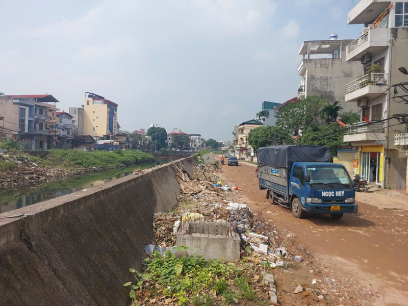
Deployed since 2019, the Yen Nghia Pumping Station and La Khe Canal project is a large project serving the goal of flood control in the western area of Hanoi . Expected to be completed in 2025, but in reality, up to this point, the project has not been completed, especially the La Khe Canal. We have recorded the reality along La Khe Canal, where the project is under construction. Construction materials and sand are scattered along the road. There are sections that cannot be implemented due to problems in site clearance. Not only that, the slow progress of the project is also significantly affecting the lives of people. According to people living on Ngo Quyen Street along La Khe Canal, when it is sunny, the dirt and road surface are damaged, dust flies everywhere, households in this section have to close all day. When it rains, it is muddy, slippery, and bumpy.
Not only the Yen Nghia Pumping Station and La Khe Water Canal projects are behind schedule, many other large projects according to the planning are also behind schedule such as: Dong My Pumping Station, Lien Mac Pumping Station... According to the drainage planning of Hanoi until 2030 approved by the Prime Minister in Decision No. 725/QD-TTg (QH725), Hanoi needs to have 48 pumping stations with a total capacity of 1,315m³/s and 5,405ha of regulating lakes. However, up to now, according to the report of the Hanoi Department of Construction, Hanoi has only reached about 20% of the pumping station capacity and 18.7% of the regulating lake area.
According to Prof. Dr. Dao Xuan Hoc, Chairman of the Vietnam Irrigation Association, many people believe that flood prevention must start from the inner city, but in reality, if the overall drainage system outside is not clear, the improvement of the internal sewers will only have limited effect. "Hanoi needs to focus on macro projects, that is, the river system, pumping stations, and drainage channels to the Red River and the Day River according to the approved planning. When water has a place to drain out, the inner city sewer improvement projects will be effective," said Prof. Dr. Dao Xuan Hoc.
Director of the Department of Construction Infrastructure (Ministry of Construction) Ta Quang Vinh also affirmed that the slow implementation of projects according to planning is a major reason why Hanoi has experienced major floods like the recent past. “Not only Hanoi, but many urban areas today also regularly face the situation of being flooded every time there is heavy rain. The common point of large urban areas is that the drainage planning has not been updated according to extreme climate scenarios, there is a lack of connectivity between drainage basins and there is no effective coordination between three key systems: Urban - irrigation - transportation. These are "bottlenecks" that need to be resolved soon so that Vietnamese urban areas can better adapt to climate change and increasingly extreme weather,” said Director Ta Quang Vinh.
Urban planning also has many problems.
According to Architect Tran Ngoc Chinh, Chairman of the Vietnam Urban Planning and Development Association, the current design of Hanoi's drainage system is based on old standards, with rainfall of about 200mm. With rainfall of 400-600mm, the current drainage system is not enough to retain and carry water down the drain.
Obviously, the drainage system is not suitable for the changing climate conditions. Another important cause of flooding mentioned by architect Tran Ngoc Chinh is the rapid urbanization process that causes roads and constructions to spring up, and the loss of water-permeable surface area. Due to too much concreting, water cannot penetrate into the ground as before. Therefore, it is necessary to reconsider the calculation of water-permeable area in the design.
“Another issue that needs to be addressed is the management of urban planning and construction. This is our problem, we cannot blame nature forever. New urban areas, many villas, and luxury residential areas (such as on Le Trong Tan and Thang Long streets...) have been severely affected by floods. First of all, when planning, we must pay attention to the issue of surveying construction sites. Flooded areas show that the elevation is not good. When developing new urban areas, urban designers, urban administrators, or investors must pay close attention to the drainage system. In newly flooded urban areas, it is clear that investors have not paid attention to these issues,” said architect Tran Ngoc Chinh.
Sharing the same opinion, Associate Professor Dr. Vu Thanh Ca also said that the lack of strict planning management is also one of the reasons leading to severe flooding every time it rains heavily in Hanoi. The current urban foundation is high in some places and low in others, causing many areas to be heavily flooded every time there is heavy rain. “The urban foundation is a fundamental factor for the drainage system to operate effectively. Water must flow from high to low along the natural slope. If the planning is wrong in terms of height, creating low-lying areas, the water will stagnate. Meanwhile, the foundation of many urban areas today is not consistent with the planning. When the investor implemented the project, there was no strict management, leading to this situation,” Associate Professor Dr. Vu Thanh Ca analyzed.
Associate Professor Dr. Vu Thanh Ca gave an example of a core area planned during the French period, which often has high terrain and a well-designed underground sewer system, so drainage is better. The current deep flooding areas are mainly in new urban areas, which is due to the lack of strict management of the ground level. According to regulations, when approving projects, the city clearly defines the ground level of each area. However, during the implementation process, many investors do not comply, even arbitrarily adjusting the height without supervision, leading to the destruction of the natural terrain. In principle, urban areas must have a reasonable slope towards large drainage outlets, but in many new urban areas, the ground level is leveled and changed arbitrarily, making the newly built area lower than the road surface and the old area. As a result, rainwater cannot drain out but stagnates inside, causing severe flooding after each heavy rain.
Director of the Department of Infrastructure (Ministry of Construction) Ta Quang Vinh also assessed that the rapid urbanization has caused the concrete surface to increase and the water-permeable soil to decrease sharply. “Along with that, the lack of synchronous planning has created low-lying areas that "catch water". When heavy rain coincides with the peak tide, the entire drainage system becomes overloaded. In fact, natural disasters are only the tip of the iceberg, while "man-made disasters" are the root. The concreting, filling of ponds and lakes, and canalization have seriously narrowed the natural water storage spaces, the "aquatic lungs" of the city. When there is no more room for water to seep in, even small rains can turn into floods,” said Mr. Vinh.
Source: https://cand.com.vn/doi-song/bai-2-khi-thien-tai-la-phan-ngon-con-nhan-tai-moi-la-goc-re-i785369/


![[Photo] President Luong Cuong holds talks with South African President Matamela Cyril Ramaphosa](https://vphoto.vietnam.vn/thumb/1200x675/vietnam/resource/IMAGE/2025/10/23/1761221878741_ndo_br_1-8416-jpg.webp)
![[Photo] Prime Minister Pham Minh Chinh chairs meeting on railway projects](https://vphoto.vietnam.vn/thumb/1200x675/vietnam/resource/IMAGE/2025/10/23/1761206277171_dsc-9703-jpg.webp)


Comment (0)