

Location of road surface cracks on National Highway 3 in Bac Kan - Photo: Department of Roads
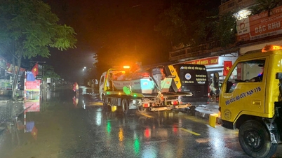
The Vietnam Road Administration ( Ministry of Construction ) said that as of October 8, storm No. 11 (international name Matmo) and subsequent floods have caused serious damage on many national highways in the northern mountainous region, especially in the provinces of Thai Nguyen, Cao Bang and Lao Cai. Many road sections have broken foundations, deep flooding, and large landslides, paralyzing traffic.
Many roads have broken foundations and are deeply flooded.
On National Highway 3B through Thai Nguyen province, at Km116+300, the roadbed was broken, the damaged section was 10 meters long, 8 meters deep, and the entire road surface collapsed. This is the location assessed to have the most severe damage, causing the entire route to be cut off.
Regarding the negative slope landslide, currently at Km 200 +903/QL3, Cao Bang area, there is currently 60m of negative slope roadbed that has collapsed, losing half of the road surface and the landslide depth is large. To ensure the safety of people and vehicles, the road must be temporarily closed for large vehicles. Only cars and motorbikes are temporarily allowed to circulate.
At the Thai Nguyen - Cho Moi BOT project, there are currently 4 locations that are still blocked due to deep flooding and landslides. Specifically, Km96+700 and Km99+600 are heavily flooded, the water has not receded; Tan Long intersection (Km75+300 - Km76) is flooded up to 0.8m, traffic must be diverted. At Km97+700, the estimated landslide volume is 2,500 m³ of earth and rock, units are urgently clearing, but traffic is still stagnant.
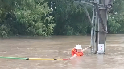
In Cao Bang alone, the Ho Chi Minh - Pac Bo section is flooded from 1.1 to 1.5m deep at many points, completely paralyzing traffic. The negative slope landslide at Km200+903 (QL3) has caused the road surface to be half-deep, forcing trucks to be banned and only cars to be allowed to pass. On Ho Chi Minh Road (Pac Bo - Cao Bang section), there are 2 spots flooded more than 1m deep, currently unable to open to traffic.

Forces are working 24/7 to fix landslides.
Vietnam Road Administration said that, amid prolonged heavy rain, forces under the Administration organized to fix the problem throughout the night of October 7, mobilizing maximum machinery and human resources.
Initial results show that 22 locations on National Highway 3 have been completely cleared; 12 landslide locations have been temporarily cleared to one lane; 3 flooded locations on National Highway 3 (the section coinciding with Ho Chi Minh Road) have been completely cleared, traffic has returned to normal; 5 locations with sunken and cracked roadbeds still allow one-way traffic. For national highways managed by local authorities, storm Matmo caused traffic jams at 37 locations (16 landslide locations, 21 flooded locations).
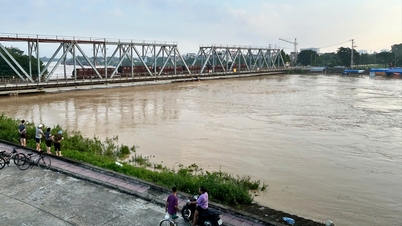
Some routes recorded serious damage such as National Highway 70 (Lao Cai) with a landslide of about 5,000 m3 of rock and soil, requiring local blockade and temporary traffic diversion; National Highway 3B (Thai Nguyen) section Km116+300 had the entire road surface broken, paralyzing traffic; National Highway 34 in Cao Bang had 6 flooded points, National Highway 34B had 1 point, and National Highway 4A had 4 cut-off points.
In Lao Cai, National Highway 70 (Km189, Phong Hai Commune) collapsed about 5,000 m³ of rock and soil, causing serious congestion. The road management unit is mobilizing cleaning machines and will temporarily clear the route as soon as possible.
According to statistics, storm No. 11 and the floods after the storm have caused 37 locations and sections of national highways managed by the locality to be blocked, of which 16 locations were due to landslides and 21 locations were due to flooding. Currently, only a few locations have been temporarily repaired, while dozens of locations are still blocked. In addition, the provincial and local road systems have also been severely affected, with about 53 blocked locations (19 due to landslides, 34 due to deep flooding), and the number of cleared locations is still limited.
Road management areas have mobilized hundreds of officers and vehicles, organized 24/7 duty, coordinated with police and local forces to set up checkpoints, direct traffic, clear rocks and soil, and ensure traffic safety in the weather conditions where heavy rain continues.
The Vietnam Road Administration said it is currently unable to estimate the damage value, as units are still focusing all their efforts on responding to and overcoming the incident, prioritizing the earliest road clearance for isolated areas.

Landslide on negative slope in Deo Gio area
Damage situation on locally managed roads
As of 12:00 on October 7, the damage situation to the road system under the management of the Provincial People's Committee and local roads, specifically:
National highways under provincial management: Storm No. 11 caused traffic jams at 37 locations/sections (16 landslides and 21 flooded locations). At the time of reporting, 31/37 locations were still jammed.
Typically, on National Highway 70 (in the old Lao Cai province) at Km189, there was a landslide of about 5,000m3, the management unit is transporting machines to clean it up. On National Highway 3B (Thai Nguyen) at Km 116+300, the entire road surface was damaged, causing traffic jams.
Provincial and other locally managed roads are currently experiencing traffic jams at 53 locations/sections (19 landslides and 34 flooding). Two locations have been cleared, but 51/53 locations are still congested.
Phan Trang
Source: https://baochinhphu.vn/nhieu-tuyen-quoc-lo-mien-nui-phia-bac-sat-lo-hu-hai-nghiem-trong-sau-bao-so-11-102251008233705477.htm
![[Photo] Prime Minister Pham Minh Chinh attends the World Congress of the International Federation of Freight Forwarders and Transport Associations - FIATA](https://vphoto.vietnam.vn/thumb/1200x675/vietnam/resource/IMAGE/2025/10/08/1759936077106_dsc-0434-jpg.webp)


![[Photo] Prime Minister Pham Minh Chinh inspects and directs the work of overcoming the consequences of floods after the storm in Thai Nguyen](https://vphoto.vietnam.vn/thumb/1200x675/vietnam/resource/IMAGE/2025/10/08/1759930075451_dsc-9441-jpg.webp)


Comment (0)