

According to the Department of Hydrometeorology ( Ministry of Agriculture and Environment ), through monitoring and analyzing the current state of the weather system and forecast products, in the next 10 days (October 16 - October 26, 2025), the mainland as well as the East Sea are likely to be affected by some dangerous natural disasters. In particular, around October 17 - 18, the tropical depression in the sea east of the Philippines is likely to strengthen into a storm.
Around October 19-20, the storm entered the East Sea.
On the evening of October 16, Director of the Department of Hydrometeorology, Ministry of Agriculture and Environment Nguyen Thuong Hien said that a new tropical depression has formed in the sea east of the Philippines. It is forecasted that around October 17-18, the tropical depression will likely strengthen into a storm with a probability of about 70-80%; with a high possibility that around October 19-20 it will move into the northeastern area of the northern part of the East Sea. Due to the influence of the tropical depression, which is likely to strengthen into a storm, from the afternoon of October 18 in the northern and central areas of the East Sea (including Hoang Sa special zone), winds will gradually strengthen and seas will be rough.
"When the storm moves into the East Sea, there will be cold air moving down from the North, so there is a possibility that the storm will weaken at sea," Director Nguyen Thuong Hien predicted.
Cold air affects the North
According to Director Nguyen Thuong Hien, from the night of October 18, the North will begin to be affected by cold air, which will then intensify during October 20-25, with cold weather at night and in the morning, and the mountainous areas may become colder. In the Gulf of Tonkin, from October 20, the Northeast wind is likely to be strong up to level 6-7, gusting to level 8, with waves 2-4 meters high and rough seas.
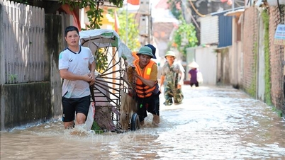
In the next 10 days, the North is very unlikely to experience heavy rain and floods on rivers.
Along with that, from October 16 to 18, the area from Quang Tri to Quang Ngai will have moderate rain, heavy rain and thunderstorms with common rainfall of 70-150 mm, locally very heavy rain over 350 mm, especially in Hue city, locally over 500 mm. From October 19, moderate rain, locally heavy rain will continue.
"In particular, it is forecasted that from October 23 to 26, the provinces in the Central region will be affected by a combination of cold air and high-altitude easterly wind disturbances. This is a typical weather pattern combined with terrain characteristics that can cause heavy rain and floods in river basins from Ha Tinh to Quang Ngai. Information on rainfall and flood warning levels will be updated in short-term forecast bulletins as prescribed," Director Nguyen Thuong Hien emphasized.
There is a possibility of 1-2 storms and tropical depressions affecting our mainland.
Regarding information on the situation of hydrometeorological disasters from now until the end of 2025, Director Nguyen Thuong Hien said that there will be about 3 storms and tropical depressions active in the East Sea; of which about 1-2 storms are likely to affect mainland Vietnam.
Severe cold may appear in the North from the second half of December 2025.
Moderate to heavy rains are likely to occur in the Central region, concentrated in the area from Ha Tinh to Da Nang, Khanh Hoa and the eastern areas of Quang Ngai and Dak Lak provinces. Meanwhile, the Northern region is less likely to experience heavy rain and floods on the Northern rivers.
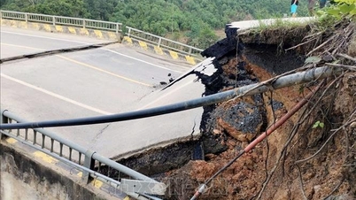
Flood peaks on rivers in the Central region are at alert level 2 - alert level 3, some places exceeding alert level 3, with the risk of late floods coinciding with the reservoir water storage period.
For the Mekong Delta region: Floods at Tan Chau and Chau Doc stations are gradually decreasing. From now until the end of December 2025, this area will be affected by 5 high tides on October 22-27, November 4-10, November 18-25, December 2-8 and December 17-24, of which, the high tides in early November and early December 2025 will raise the water level at downstream stations to alert level 2 - alert level 3 and above alert level 3. There is a high risk of flooding and dike overflow in low-lying, coastal, riverside and outside dike areas.
In the 2025-2026 dry season in the Southern region, the salinity intrusion situation will be lower than the average of many years and lower than in 2024-2025.
The ENSO phenomenon (El Nino and La Nina) is forecasted to have a 60-75% chance of maintaining La Nina conditions in the next three months.
Director Nguyen Thuong Hien stated that in order to proactively respond promptly and effectively to ensure the safety of people's lives and minimize property damage, in addition to the forecast and warning bulletins of natural disasters issued periodically according to regulations, to monitor real-time forecast and warning information of thunderstorms, tornadoes, lightning, flash floods, landslides, it is recommended that units, local authorities, people... access the warning systems of the Department of Hydrometeorology at: http://iweather.gov.vn/ and http://luquetsatlo.nchmf.gov.vn/ to update information.
Source: https://baotintuc.vn/van-de-quan-tam/ap-thap-nhiet-doi-co-kha-nang-manh-len-thanh-bao-di-vao-bien-dong-20251016201457603.htm


![[Photo] Nhan Dan Newspaper launches “Fatherland in the Heart: The Concert Film”](https://vphoto.vietnam.vn/thumb/1200x675/vietnam/resource/IMAGE/2025/10/16/1760622132545_thiet-ke-chua-co-ten-36-png.webp)


Comment (0)