
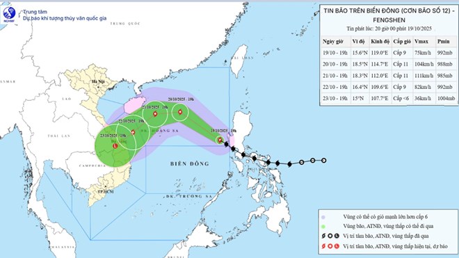
Updated position and path of storm No. 12 Fengshen at 8:00 p.m. on October 19. Source: National Center for Hydro-Meteorological Forecasting
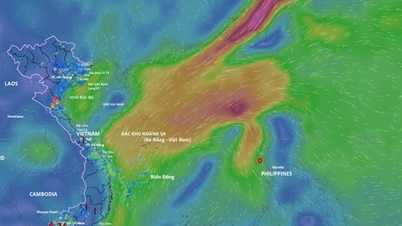
Updated from the National Center for Hydro-Meteorological Forecasting, at 7:00 p.m. on October 19, the center of storm No. 12 was located at about 15.6 degrees north latitude - 119 degrees east longitude, about 750 km east-southeast of Hoang Sa special zone. The strongest wind near the center of the storm was level 9 (75 - 88 km/h), gusting to level 11. The storm moved northwest at a speed of about 25 km/h.
Forecast in the next 24 hours , the storm will move northwest at a speed of 20-25 km/h and is likely to strengthen.
At 7:00 p.m. on October 20, the center of the storm was at about 18.5 degrees north latitude - 114.7 degrees east longitude, in the North East Sea, about 330 km northeast of Hoang Sa special zone. Strong winds of level 10-11, gusting to level 13.
The danger zone is from 15-20.5 degrees north latitude, east of 112 degrees east longitude. Disaster risk level 3 for the North East Sea area (including Hoang Sa special zone).
It is forecasted that in the next 48 hours, the storm will move west at a speed of 10-15 km/h and continue to strengthen.
At 7:00 p.m. on October 21, the center of the storm was at about 18.3 degrees north latitude - 112.0 degrees east longitude, in the western sea area of the North East Sea, about 180 km north of Hoang Sa special zone. Strong winds of level 11, gusts of level 13.
The danger zone is from 16.5-20.5 degrees north latitude; 110-117 degrees east longitude. Disaster risk level 3, North East Sea area (including Hoang Sa special zone).
It is forecast that in the next 72 hours, the storm will move southwest at a speed of 10-15 km/h and may gradually weaken.
At 7:00 p.m. on October 22, the center of the storm was at about 16.4 degrees north latitude - 109.6 degrees east longitude, in the sea northwest of Hoang Sa special zone, about 130 km east of Da Nang city. Wind force level 9, gust level 11.
The danger zone is from 14.5-20 degrees north latitude, west of 114 degrees east longitude. Level 3 natural disaster risk, sea area west of the North East Sea (including Hoang Sa special zone), sea area from Hue to Quang Ngai .
From the next 72 to 120 hours , the storm moved mainly in a southwest direction, about 10 km per hour and gradually weakened into a low pressure area.
Regarding the impact of storms at sea , the North East Sea area (including Hoang Sa special zone) has strong winds of level 7-8, near the storm center level 9-11, gusting to level 13; waves 3-5 m high, near the storm center 5-7 m high; rough seas. All ships operating in the above-mentioned dangerous areas are likely to be affected by storms, whirlwinds, strong winds and big waves.
On land, due to the influence of storm circulation combined with cold air, from October 22 to 27, the area from Ha Tinh to Quang Ngai is likely to experience widespread heavy rain, with some places experiencing very heavy rain.
There is a high risk of flash floods and landslides in mountainous areas and localized flooding in low-lying areas and urban areas. Water levels on rivers from Quang Tri to Quang Ngai are likely to rise to alert level 3 and above. The level of natural disaster risk due to floods is level 3.
Laodong.vn
Source: https://laodong.vn/moi-truong/bao-so-12-sap-manh-len-cung-luc-khong-khi-lanh-tang-cuong-don-dap-gay-mua-to-1594588.ldo


Comment (0)