
 |
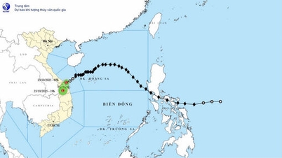
| Low pressure area path diagram. (Source: Center for Hydro-Meteorological Forecasting) |
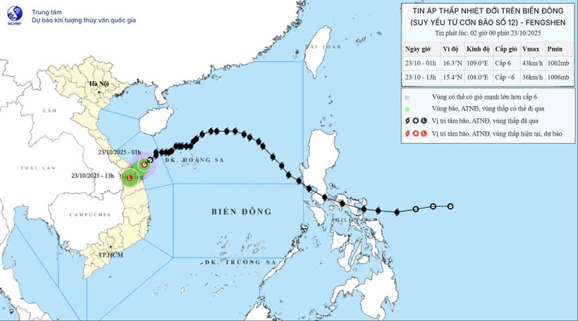
According to the National Center for Hydro-Meteorological Forecasting, storm No. 12 has weakened into a tropical depression.
Tropical depression moves inland from Da Nang to Quang Ngai
At 1:00 a.m. on October 23, the center of the tropical depression was at about 16.3 degrees North latitude; 109.0 degrees East longitude, on the sea from South Quang Tri to Quang Ngai , about 80km East Northeast of Da Nang city.
The strongest wind near the center of the tropical depression is level 6 (39-49km/h), gusting to level 8. Moving southwest at a speed of 10-15km/h.
It is forecasted that by 1:00 p.m. on October 23, the tropical depression on the mainland from Da Nang city to Quang Ngai with winds below level 6, moving southwest at a speed of 10-15 km/h and gradually weakening into a low pressure area.
The affected area is the sea from Quang Tri to Quang Ngai (including the special zones of Con Co, Ly Son, and Cu Lao Cham islands). Disaster risk level 3.
Due to the combined influence of cold air, the sea area from Quang Tri to Quang Ngai (including the special economic zones of Con Co, Ly Son, and Cu Lao Cham islands) has strong winds of level 6, gusts of level 8; waves 2-4m high, rough seas.
Coastal areas from Quang Tri Province to Da Nang City have water levels rising due to strong winds from 0.3-0.6m.
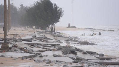
Warning: Coastal areas and river mouths from South Quang Tri to Da Nang city need to be on guard against large waves combined with high tides and rising water due to strong winds causing flooding in low-lying areas, waves overflowing coastal roads and riverbanks, and coastal erosion. All ships, boats, and aquaculture areas in the above-mentioned dangerous areas are likely to be affected by storms, whirlwinds, strong winds, large waves, and rising sea levels.
Due to the influence of the tropical low pressure circulation and cold air combined with East wind disturbances and topographic effects, from the night of October 22 to the night of October 24, the area from Ha Tinh to Quang Ngai will have heavy rain and thunderstorms with common rainfall of 100-200mm, locally with very heavy rain over 300mm; especially the area from South Quang Tri to Da Nang city will have heavy to very heavy rain with common rainfall of 200-400mm, locally with over 700mm.
Warning of risk of heavy rain over 150mm/3 hours in coastal communes/wards from South Quang Tri to Da Nang city.
Heavy rains in the Central region are likely to last until the end of October 2025. There is a high risk of flash floods and landslides in mountainous areas, flooding in low-lying areas and urban areas. Localities need to pay attention to the safe operation of hydroelectric and irrigation reservoirs before, during and after the storm, and prepare response plans for flood scenarios on rivers from South Quang Tri to Da Nang that may reach alert levels 2-3, with some places above alert level 3. Forecast level of natural disaster risk due to floods: level 2-3.
Tropical depression near the East Sea
Regarding the development of the tropical depression near the East Sea, the National Center for Hydro-Meteorological Forecasting stated that at 1:00 a.m. on October 23, the center of the tropical depression was at about 21.0 degrees North latitude; 122.4 degrees East longitude. The strongest wind near the center of the tropical depression was level 7 (50-61 km/h), gusting to level 9. Moving in the South-Southwest direction at a speed of about 10-15 km/h.
Forecast until 1:00 a.m. on October 24, the tropical depression in the eastern sea of the North East Sea with strong winds of level 6-7, gusts of level 9, moving in the South-Southwest direction at a speed of 20-25 km/h. The affected area is the eastern sea of the North East Sea. Disaster risk level 3.
Then, at 1:00 a.m. on October 25, the tropical depression was about 250 km east of Hoang Sa special zone with winds below level 6, moving southwest at a speed of about 20-25 km/h, gradually weakening. The affected area is the sea area south of the North East Sea. Disaster risk level 3.
Heavy rain in many areas
According to the forecast of the Hydrometeorological Agency, from early morning of October 23 to night of October 24, the area from Ha Tinh to Quang Ngai will have heavy rain and thunderstorms with common rainfall of 100-200mm, locally very heavy rain over 300mm; especially the area from South Quang Tri to Da Nang city will have heavy to very heavy rain with common rainfall of 200-400mm, locally over 700mm.
Warning of risk of heavy rain over 150mm/3h.
In addition, on the day and night of October 23, the area from Gia Lai to Lam Dong and the South will have scattered showers and thunderstorms with rainfall of 15-30mm, with some places having heavy rain of over 80mm. During thunderstorms, there is a possibility of tornadoes, lightning, hail and strong gusts of wind.
Warning of risk of heavy rain over 60mm/3h.
From early morning of October 23 to night of October 24, the area from Ha Tinh to Quang Ngai will have heavy rain and thunderstorms with common rainfall of 100-200mm, locally very heavy rain over 300mm; especially the area from South Quang Tri to Da Nang city will have heavy to very heavy rain with common rainfall of 200-400mm, locally over 700mm.
Warning of risk of heavy rain over 150mm/3h.
In addition, on the day and night of October 23, the area from Gia Lai to Lam Dong and the South will have scattered showers and thunderstorms with rainfall of 15-30mm, locally heavy rain over 80mm. Warning of the risk of heavy rain over 60mm/3 hours.
"Thunderstorm areas are at risk of tornadoes, lightning, hail and strong gusts of wind," Deputy Head of Weather Forecasting Department Le Thi Loan noted.
Beware of flash floods and landslides from Ha Tinh to Da Nang
According to the National Center for Hydro-Meteorological Forecasting, from 4:50 a.m. to 9:50 a.m. on October 23, the provinces from Ha Tinh to Da Nang city will continue to have rain. There is a risk of flash floods and landslides in the above provinces.
Specifically, the accumulated rainfall is generally from 5-20mm, in some places over 50mm. Warning of the risk of flash floods and landslides in the following communes and wards: Cam Lac, Ky Xuan, Vung Ang; Cam Hung, Cam Trung, Ky Anh, Ky Hoa, Ky Khang, Ky Lac, Ky Thuong, Ky Van, Hai Ninh, Hoanh Son, Song Tri (Ha Tinh province); Ta Rut; Dakrong, Phu Trach; Ai Tu, Ba Long, Ben Quan, Bo Trach, Cam Lo, Hai Lang, Kim Ngan, Le Ninh, Nam Trach, Dong Son, Quang Tri, Quang Ninh, Truong Ninh, Truong Phu, Truong Son (Quang Tri province); Phu Loc; Chan May - Lang Co, Khe Tre, Loc An, Phong Dien; A Luoi 1, A Luoi 4, A Luoi 5, Binh Dien, Hung Loc, Nam Dong, Huong An, Huong Tra, Kim Long, Kim Tra, Phong Thai, Phu Bai (Hue city); Hai Van (Da Nang city).
Warning level of natural disaster risk due to flash floods, landslides, land subsidence due to heavy rain or level 1 flow.
Flash floods and landslides can have very negative impacts on the environment, threaten people's lives; cause local traffic congestion, and affect the process of transportation.
movement of vehicles; destruction of civil and economic works, causing damage to production and socio-economic activities.
The Hydrometeorological Agency recommends that local authorities pay attention to reviewing bottlenecks and vulnerable locations in the area to have prevention and response measures.
Weather in regions day and night October 23
In the Northwest, there will be some rain and light wind. Cold in the morning and at night. Lowest temperature 18-21 degrees Celsius, some places below 17 degrees Celsius. Highest temperature 24-27 degrees Celsius, some places above 27 degrees Celsius.
In the Northeast, there will be rain in some places; in the plains and coastal areas, there will be scattered rain. Northeast wind level 3, in coastal areas level 4. Cold weather; in mountainous areas, it will be cold in the morning and at night. Lowest temperature 18-21 degrees Celsius, in mountainous areas, some places below 17 degrees Celsius. Highest temperature 21-24 degrees Celsius, some places above 24 degrees Celsius.
Hanoi city sometimes has rain. Northeast wind level 3, cold weather. Lowest temperature 19-21 degrees Celsius. Highest temperature 21-24 degrees Celsius.
Provinces and cities from Thanh Hoa to Hue, in the North (Thanh Hoa - Nghe An), there will be scattered rain, in the South there will be moderate rain, heavy rain and thunderstorms, locally very heavy rain; in the South of Quang Tri and Hue city there will be heavy to very heavy rain, in thunderstorms there is a possibility of tornadoes, lightning and strong gusts of wind. The morning and night will be cold. North to Northwest wind level 3-4. Lowest temperature 19-22 degrees Celsius. Highest temperature 21-24 degrees Celsius, some places above 24 degrees Celsius.
South Central Coast: Northern part cloudy, with moderate rain, heavy rain and thunderstorms, locally very heavy rain, especially in Da Nang city. In the afternoon and evening in the South, there will be scattered showers and thunderstorms, locally heavy rain, with the possibility of tornadoes, lightning and strong gusts of wind during thunderstorms. Northeast wind level 3-4. Lowest temperature 23-26 degrees Celsius. Highest temperature in the North 26-29 degrees Celsius; in the South 29-32 degrees Celsius.
The Central Highlands has scattered showers and thunderstorms; in the afternoon and evening, there will be scattered showers and thunderstorms, locally heavy rain, with the possibility of tornadoes, lightning, hail and strong gusts of wind. Northeast wind level 2-3. Lowest temperature 19-22 degrees Celsius. Highest temperature 27-30 degrees Celsius, some places over 30 degrees Celsius.
The South has scattered showers and thunderstorms, some places have heavy rain, thunderstorms have the possibility of tornadoes, lightning, hail and strong gusts of wind. Lowest temperature 23-26 degrees Celsius. Highest temperature 31-34 degrees Celsius, some places above 34 degrees Celsius.
Ho Chi Minh City has scattered showers and thunderstorms, some places have heavy rain, in thunderstorms there is a possibility of tornadoes, lightning, hail and strong gusts of wind. Lowest temperature 24-26 degrees Celsius. Highest temperature 31-34 degrees Celsius./.
Source: https://huengaynay.vn/chinh-tri-xa-hoi/theo-dong-thoi-su/bao-so-12-suy-yeu-huong-ve-dat-lien-da-nang-den-quang-ngai-159094.html


![[Photo] Prime Minister Pham Minh Chinh chairs meeting on railway projects](https://vphoto.vietnam.vn/thumb/1200x675/vietnam/resource/IMAGE/2025/10/23/1761206277171_dsc-9703-jpg.webp)


Comment (0)