
Latest floods on the Red River and rivers in the North
According to the National Center for Hydro-Meteorological Forecasting, the flood situation on rivers in the past hours shows that the flood on Cau River (Bac Ninh Province) is receding slowly. The flood on Thai Binh River (Hai Duong City) is receding slowly. The flood on Hoang Long River (Ninh Binh Province) at Ben De is receding slowly.
Flood on Thuong River ( Bac Giang Province) is receding slowly. Flood on Red River (Hanoi City) is receding quickly. Flood on Luc Nam River (Bac Giang Province) is receding slowly.
Water levels at 07:00/13/9, on rivers as follows:
On Cau River at Dap Cau 7.66m, above alarm level 3 1.36m; below historical flood level in 1971 (7.84m) 0.18m. On Thuong River at Phu Lang Thuong 6.95m, above alarm level 3 0.65m.
On the Luc Nam River at Luc Nam, it is 6.23m, 0.07m below alarm level 3. On the Hoang Long River at Ben De, it is 4.82m, 0.82m above alarm level 3; on the Thai Binh River at Pha Lai, it is 6.04m, 0.04m above alarm level 3; on the Red River at Hanoi , it is 10.02m, 0.48m below alarm level 2.
The National Center for Hydro-Meteorological Forecasting forecasts that in the next 24 hours, water levels at many downstream stations of the Red-Thai Binh river system will tend to change slowly, generally remaining at high levels from alert 2 to alert 3, with some places above alert 3 and slowly decreasing.
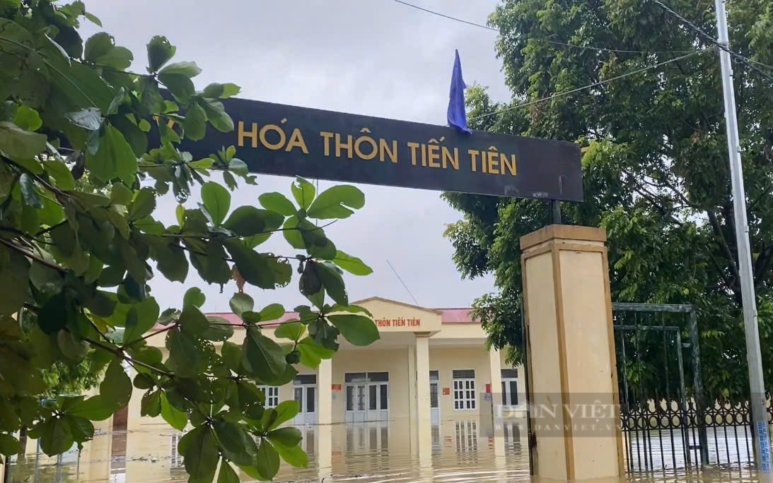
After just one night, all the villages in Chuong My (Hanoi) were submerged in water, it is forecasted that it will take 10-13 days for the water to completely recede in low-lying areas. Photo: Pham Thu
Specifically, in the next 12 hours, flood levels on the Luc Nam River will drop below alert level 3; on the Cau River at Dap Cau, the Thuong River at Phu Lang Thuong, the Luc Nam River at Luc Nam, and the Hoang Long River at Ben De will continue to drop but remain above alert level 3; flood levels on the Red River in Hanoi will drop to alert level 1.
In the next 12-24 hours, floods on Cau, Thuong and Hoang Long rivers will continue to recede but remain above alert level 3; Luc Nam and Thai Binh rivers will continue to recede but remain above alert level 2; floods on the Red River in Hanoi will fall below alert level 1.
Flood warning for flooded areas
Although the water level of the rivers has decreased as warned by the National Center for Hydro-Meteorological Forecasting, the process of flood drainage and reduction on the Red River system is likely to be slow, so flooding will continue for many days in low-lying areas, low-lying areas along rivers, and alluvial areas outside the main dike in the following provinces/cities: Hanoi, Bac Giang, Bac Ninh, Thai Nguyen, Ninh Binh, Nam Dinh, Thai Binh, Ha Nam, Hai Duong.
With the forecasted decrease in rain in the coming days, flooding in low-lying areas along the river will gradually improve.
"In addition to the Red River dike in Hanoi, water will be drained in the next 2-3 days, especially in low-lying areas in Chuong My along the Bui River in 10-13 days, the Tich River in about 7-10 days, the downstream of the Ca Lo River in 3-5 days, and the Nhue River in 2-3 days," the bulletin of the National Center for Hydro-Meteorological Forecasting noted.
In the downstream riverside areas of the Red River - Thai Binh River (provinces of Bac Giang, Bac Ninh, Ha Nam, Ninh Binh, Nam Dinh, Hung Yen, Thai Binh, Hai Duong), the water withdrawal time will last longer, from 3-6 days.
Flood water levels in the lower reaches of the Red River are currently at high levels (level 3 - above level 3), so there is still a risk of affecting riverside dykes and landslides at key locations in the following provinces/cities: Hanoi, Ha Nam, Nam Dinh, Hai Duong, Hung Yen, Thai Binh, Ninh Binh.
The risk of landslides remains on steep slopes in mountainous areas of the North despite the reduction of rain.
Source: https://danviet.vn/lu-tren-hang-loat-song-da-xuong-vung-trung-thap-chuong-my-cua-ha-noi-van-phai-mat-10-13-ngay-de-nuoc-rut-20240913100122427.htm


![[Photo] Hanoi morning of October 1: Prolonged flooding, people wade to work](https://vphoto.vietnam.vn/thumb/1200x675/vietnam/resource/IMAGE/2025/10/1/189be28938e3493fa26b2938efa2059e)


![[Photo] President Luong Cuong receives President of the Cuban National Assembly Esteban Lazo Hernandez](https://vphoto.vietnam.vn/thumb/1200x675/vietnam/resource/IMAGE/2025/9/30/4d38932911c24f6ea1936252bd5427fa)
![[Photo] Panorama of the cable-stayed bridge, the final bottleneck of the Ben Luc-Long Thanh expressway](https://vphoto.vietnam.vn/thumb/1200x675/vietnam/resource/IMAGE/2025/9/30/391fdf21025541d6b2f092e49a17243f)


Comment (0)