
 |
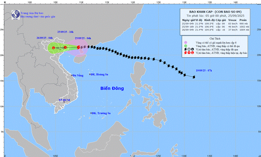
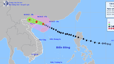
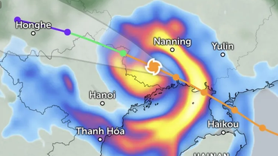
| The path of storm No. 9. Photo: www.nchmf.gov.vn |
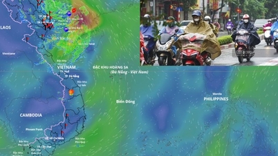
The Northwestern sea area of the North East Sea has strong winds of level 6-8, gusts of level 10, waves 3.0-5.0m high; rough seas. The Northern Gulf of Tonkin (including Bach Long Vi, Van Don, Co To, Cat Hai and Hon Dau islands) has strong winds of level 6-7, waves 2.0-3.0m high, the area near the storm center has winds of level 8-9, gusts of level 11, waves 3.0-4.0m high; rough seas.
Ships and aquaculture areas in dangerous areas are strongly affected by wind, big waves and rising sea levels.
Coastal areas from Quang Ninh to Hai Phong have winds gradually increasing to level 6-7, near the storm center level 8, gusting to level 9-10; inland areas in the Northeast, there are strong winds of level 5, in some places level 6, gusting to level 7-8.
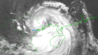
From early morning of September 25 to the end of the night of September 26, in the Northern region, Thanh Hoa and Nghe An, there will be heavy to very heavy rain with common rainfall of 150-300mm, locally over 450mm. Beware of heavy rain causing urban flooding.
Detailed forecast for the areas:
Hanoi : Cloudy, moderate rain, heavy rain and thunderstorms, locally very heavy rain. North to Northwest wind level 2-3, from early morning the wind gradually increases to level 5. Lowest temperature 23-25 degrees Celsius. Highest temperature 27-29 degrees Celsius.
Northwest: Cloudy at night with scattered showers and thunderstorms; cloudy during the day with heavy to very heavy rain and thunderstorms. Light wind. During thunderstorms, there is a possibility of tornadoes, lightning, and strong gusts of wind. Lowest temperature 22-25 degrees Celsius, below 21 degrees Celsius in some places. Highest temperature 27-30 degrees Celsius.
Northeast: Cloudy, moderate rain at night, heavy rain and scattered thunderstorms, locally very heavy rain; heavy to very heavy rain and thunderstorms during the day. North to Northwest wind level 2-3, from early morning coastal areas from Quang Ninh to Hung Yen have winds gradually increasing to level 6-7, near the storm center level 8-9, gusting to level 11; in inland areas strong winds level 5, in some places level 6, gusting to level 7-8. During thunderstorms there is a possibility of tornadoes, lightning and strong gusts. Lowest temperature 23-26 degrees Celsius, in mountainous areas below 23 degrees Celsius. Highest temperature 26-29 degrees Celsius.
Thanh Hoa to Hue: Cloudy, scattered showers and thunderstorms at night in the North, heavy to very heavy rain and thunderstorms during the day; scattered showers and thunderstorms in the South. North to Northwest wind level 2-3. During thunderstorms, there is a possibility of tornadoes, lightning, hail and strong gusts of wind. Lowest temperature 24-27 degrees Celsius. Highest temperature 28-31 degrees Celsius.
Da Nang to Binh Thuan: Cloudy, scattered showers and thunderstorms in the late afternoon and at night, sunny during the day. West to Southwest wind level 2-3. During thunderstorms, there is a possibility of tornadoes, lightning, hail and strong gusts of wind. Lowest temperature 24-27 degrees Celsius. Highest temperature 31-34 degrees Celsius.
Central Highlands: Cloudy, scattered showers and thunderstorms, scattered showers and thunderstorms in the late afternoon and evening, locally heavy rain. Southwest wind level 2-3. During thunderstorms, there is a possibility of tornadoes, lightning, hail and strong gusts of wind. Lowest temperature 19-22 degrees Celsius. Highest temperature 27-30 degrees Celsius.
Southern region: Cloudy, scattered showers and thunderstorms in some places, scattered showers and thunderstorms in the late afternoon and evening, locally heavy rain. Southwest wind level 2-3. During thunderstorms, there is a possibility of tornadoes, lightning, hail and strong gusts of wind. Lowest temperature 24-27 degrees Celsius. Highest temperature 30-33 degrees Celsius.
Source: https://baothainguyen.vn/tin-moi/202509/thoi-weather-hom-nay-25-9-bao-so-9-cach-mong-cai-quang-ninh-khoang-170km-gio-giat-cap-11-a9a0d6c/


![[Photo] Prime Minister Pham Minh Chinh chairs the Government's online conference with localities](https://vphoto.vietnam.vn/thumb/1200x675/vietnam/resource/IMAGE/2025/10/5/264793cfb4404c63a701d235ff43e1bd)

![[Photo] Prime Minister Pham Minh Chinh launched a peak emulation campaign to achieve achievements in celebration of the 14th National Party Congress](https://vphoto.vietnam.vn/thumb/1200x675/vietnam/resource/IMAGE/2025/10/5/8869ec5cdbc740f58fbf2ae73f065076)


![[VIDEO] Summary of Petrovietnam's 50th Anniversary Ceremony](https://vphoto.vietnam.vn/thumb/402x226/vietnam/resource/IMAGE/2025/10/4/abe133bdb8114793a16d4fe3e5bd0f12)

![[VIDEO] GENERAL SECRETARY TO LAM AWARDS PETROVIETNAM 8 GOLDEN WORDS: "PIONEER - EXCELLENT - SUSTAINABLE - GLOBAL"](https://vphoto.vietnam.vn/thumb/402x226/vietnam/resource/IMAGE/2025/7/23/c2fdb48863e846cfa9fb8e6ea9cf44e7)


Comment (0)