
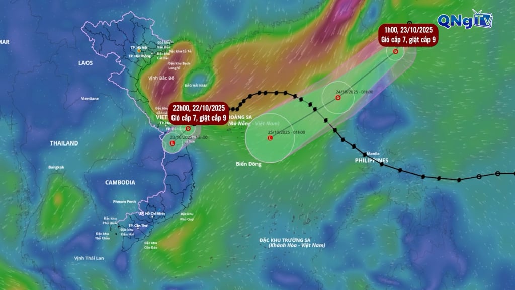
After a day of slow movement due to strong interaction with cold air, at 10:00 p.m. last night, October 22, when about 130 km from Da Nang City, storm No. 12 weakened into a tropical depression. The strongest wind was 61 km/h, level 7, gusting to level 9, down three levels compared to noon of the same day. The tropical depression moved inland and weakened into a low pressure area on the mainland of Da Nang - Quang Ngai.
At the same time, at around 1am this morning, the Taiwan sea area is experiencing a tropical depression, which is forecast to enter the East Sea today. The strongest wind near the center of the tropical depression is level 7 (50-61km/h), gusting to level 9. Moving in a southwest direction at a speed of about 10-15km/h. Since the beginning of the year, the East Sea has seen 12 storms and 4 tropical depressions.
It is forecasted that this year the East Sea may see 18 storms and tropical depressions, 1.5 times higher than the average of many years.
2025 will be the year with the third most storms and tropical depressions in the past 30 years, after 2013 with 19 storms and 2017 with 20 storms.
Source: https://quangngaitv.vn/bao-so-12-suy-yeu-them-ap-thap-nhiet-doi-se-vao-bien-dong-6509045.html

![[Photo] Prime Minister Pham Minh Chinh chairs meeting on railway projects](https://vphoto.vietnam.vn/thumb/1200x675/vietnam/resource/IMAGE/2025/10/23/1761206277171_dsc-9703-jpg.webp)


Comment (0)