
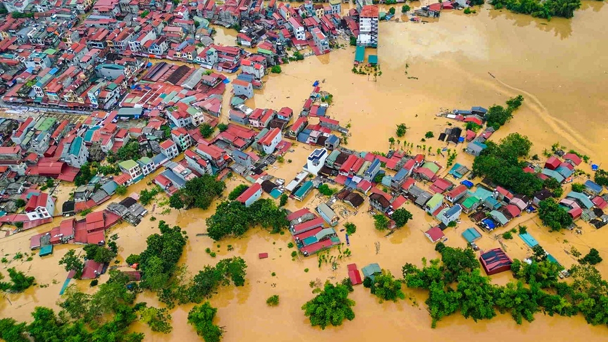
On the regional development map, Can Gio is located in a special position as a natural bridge between the center of Ho Chi Minh City, Vung Tau and the industrial zones and seaports in the South. The journey from the urban area to the sea passes through this land, making Can Gio a central point in the coastal trade and tourism circuit. However, for many years, this potential has been held back by limited infrastructure, preventing Can Gio from fully promoting its role as a true gateway to the sea.
Infrastructure will stimulate Can Gio development
From an area located in the middle of a mangrove forest with difficult transportation, Can Gio is facing a great opportunity to become a modern coastal city of Ho Chi Minh City. A series of strategic traffic projects are being promoted, which will help Can Gio grow and become an important connection point in the Southeast coastal development corridor.
“Currently, travel to Can Gio only depends on a single route through Binh Khanh ferry, which is Rung Sac road. To make a breakthrough, Can Gio must be strongly connected to the central area and neighboring economic zones” - Dr. Tran Du Lich - economic expert opened the conversation with Tien Phong reporter about the development orientation of this land.
According to him, a series of transport infrastructure projects that are being and will be implemented are the "leverage" for Can Gio to change its appearance and unlock the potential of its marine economy, which has been held back for many years.

The first is Can Gio Bridge, which will replace Binh Khanh Ferry, the only current traffic route. “This bridge is not only a convenient means of transportation for people, but also the first step for Can Gio to join the traffic network of Ho Chi Minh City and the Southeast region,” said Mr. Lich.
Second, the high-speed railway line is more than 48km long, starting from District 7 (old) and extending to the Can Gio coastal urban area. The project is expected to create a strong driving force for the development of the Can Gio coastal urban area, while also serving the operation of the Can Gio transit port area under development.

Third is the coastal road connecting Ca Mau through Cai Mep - Thi Vai port area, connecting to Ring Road 3, 4, Ben Luc - Long Thanh Expressway. In particular, in the city planning, there is a sea route connecting Can Gio to Vung Tau, which has just been proposed for investment research.
“When completed, this coastal route will play a role in economic development and have strategic value in terms of national security and defense. It will help Can Gio become the midpoint in the southern coastal corridor, from Ho Chi Minh City to Ca Mau Cape,” Dr. Tran Du Lich analyzed.
 through Ganh Rai Bay (connecting the two banks of Can Gio - Vung Tau).")
According to the expert, the bridge, railway, and sea-crossing road projects from Can Gio to Vung Tau, when completed, will not only change the way people travel, but also reshape the development flow of the entire region.
Tourists from Vung Tau can go to Can Gio in about 10 minutes for a vacation, Ho Chi Minh City residents have more options to live by the sea, and businesses will benefit from the complete logistics corridor. With the infrastructure completed, Can Gio will no longer be a coastal district, but will become a new center, a new convergence of commercial and tourism services and promote the marine economy.
Expanding development space from the new growth pole of Ho Chi Minh City
According to experts, after Ho Chi Minh City expands its development space to the East and South, Can Gio will no longer be just a mangrove ecological area, but will become a "new growth pole" associated with the marine economy and eco-tourism.
“After the expansion, Ho Chi Minh City will not only have 23km of coastline like before, but will also extend to the Ba Ria - Vung Tau area, opening up huge advantages for the marine economy,” said Mr. Tran Du Lich.
According to him, after expanding its administrative boundaries, Can Gio international transit port will coordinate with Cai Mep - Thi Vai deep-water port to form a hub (international cargo transit center) with a strategic location in Southeast Asia.
“It can be said that after the merger, the advantages of Ho Chi Minh City - Ba Ria - Vung Tau - Binh Duong will not only be cumulative, but also multiplied many times. At this time, it is not 1+1+1=3, but 1+1+1=5 or 7” - he compared.

Sharing the same view, Doctor of Science - Architect Ngo Viet Nam Son - urban planning expert - said that one of the key points is to upgrade regional transport infrastructure commensurate with the marine economic development planning, creating inter-regional logistics corridors, multi-modal connectivity: road - highway - railway - high-speed rail - waterway and even air route".
According to Dr. Ngo Viet Nam Son, when the infrastructure is completed, Can Gio will no longer develop alone, but will be part of a chain of coastal tourist cities stretching from Can Gio - Vung Tau - Long Hai - Ho Tram - Phan Thiet.

“In Can Gio, the area near the mangrove forest can develop eco-tourism; the reclaimed sea area can learn from the Dubai urban sea model; and along the east coast there are a series of resorts and high-end resorts. A continuous coastal tourism axis will attract domestic and foreign visitors thanks to convenient transportation, especially when the infrastructure connects with major airports such as Long Thanh and Tan Son Nhat,” Mr. Son suggested.
He also believes that the development of Can Gio will contribute to redistributing population and employment, reducing urbanization pressure in the city center. “When the connecting traffic infrastructure is completed, workers can choose to live and work in the suburbs, from Binh Duong to Ba Ria - Vung Tau, Can Gio will create a space for widespread and sustainable development,” he added.

When billion-dollar traffic routes are simultaneously formed, Can Gio will not only play the role of a simple “green lung” but will become a comprehensive development pole, converging urban, tourism, seaport and logistics. With its midpoint position in the coastal axis, this land is expected to lead the wave of migration to the South, bringing Ho Chi Minh City closer to the goal of becoming a modern, dynamic and sustainable coastal city.
Source: https://ttbc-hcm.gov.vn/ha-tang-ty-do-mo-loi-can-gio-tro-thanh-cuc-tang-truong-huong-bien-cua-tphcm-1019713.html
![[Photo] Prime Minister Pham Minh Chinh chairs the 16th meeting of the National Steering Committee on combating illegal fishing.](https://vphoto.vietnam.vn/thumb/1200x675/vietnam/resource/IMAGE/2025/10/07/1759848378556_dsc-9253-jpg.webp)


Comment (0)