
 |
Illustrative photo. (Source: VNA) |
According to the National Center for Hydro-Meteorological Forecasting, around the morning of October 19, cold air will affect the Northeast region; from October 20-22, cold air will be strengthened, affecting other places in the Northeast and North Central regions, then affecting some places in the Northwest and North Central regions.
Many areas have rain
According to the National Center for Hydro-Meteorological Forecasting, due to the influence of cold air, on the night of October 18 and October 19, in the Northeast region, there will be scattered showers and thunderstorms. Inland, the wind will change to Northeast level 2-3, coastal areas level 3-4.
From the night of October 20, the weather in the Northern region will turn cold at night and morning, and cold in the mountainous areas. The lowest temperature during this cold air mass in the Northern Delta is generally 19-21 degrees Celsius, in the mountainous and midland areas 17-19 degrees Celsius, and in some high mountainous areas below 16 degrees Celsius.
In Hanoi , on the night of October 18 and on October 19, there will be scattered showers and thunderstorms in some places. From the night of October 20, the night and morning will be cold. The lowest temperature in this cold air mass is commonly 19-21 degrees Celsius.
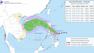
At sea, from October 19, the North East Sea will have strong northeast winds of level 6, gusts of level 7-8, rough seas; in the Eastern sea, the winds will gradually increase to level 6-7, near the storm center, strong winds of level 8, gusts of level 10, rough seas, waves 2.5-4.5m high. From the evening and night of October 19, in the Gulf of Tonkin, the northeast winds will gradually increase to level 6, gusts of level 7-8, rough seas, waves 1.5-3m high.
Due to the influence of cold air, from the evening and night of October 19, in the North and Central Central regions, there will be rain, moderate rain and thunderstorms, especially in the South, there will be some places with heavy rain. Thunderstorms accompanied by tornadoes, lightning, hail and strong gusts of wind can affect agricultural production, break trees, damage houses, traffic works and infrastructure.
Heavy rain can cause flooding in low-lying areas; flash floods in small rivers and streams, landslides on steep slopes; heavy rain in a short period of time can cause flooding in urban areas and industrial zones.
Strong winds and gusts, large waves at sea are likely to affect boat operations and other activities.
The National Center for Hydro-Meteorological Forecasting also forecasts that from the morning of October 18 to the end of the night of October 19, the area from Ha Tinh to Quang Ngai will have moderate rain, heavy rain, locally very heavy rain and thunderstorms with common rainfall in the area from Quang Tri to Da Nang city of 100-200mm, locally over 350mm; in Ha Tinh and Quang Ngai 60-120mm, locally over 200mm. Warning of the risk of heavy rain over 80mm/3 hours.
In addition, on the day and night of October 18, in Nghe An, the area from Gia Lai to Lam Dong and the South, there will be scattered showers and thunderstorms with rainfall of 10-30mm, locally heavy rain over 60mm (rain is mainly concentrated in the afternoon and evening).
From October 20, heavy rain in the above area tends to decrease gradually. Disaster risk level due to heavy rain, tornadoes, lightning, hail: level 1.
"Heavy rain is likely to cause flooding in low-lying areas, urban and industrial areas; flash floods on small rivers and streams, landslides on steep slopes (real-time warning information on areas at risk of flash floods and landslides is provided online on the website of the Department of Hydrometeorology at: https://luquetsatlo.nchmf.gov.vn and in a separate bulletin warning of flash floods and landslides). During thunderstorms, there is a possibility of tornadoes, lightning, hail and strong gusts of wind," noted Head of the Weather Forecast Department Nguyen Van Huong.
Flood warning on rivers
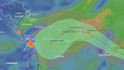
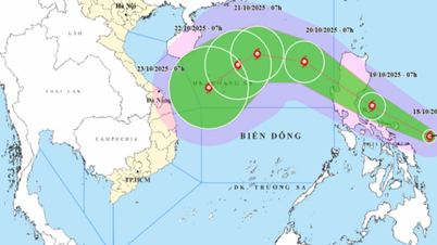
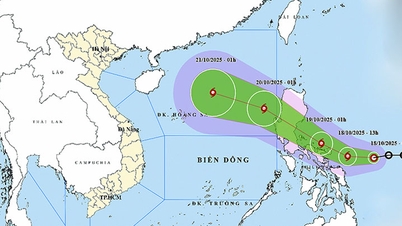
The National Center for Hydro-Meteorological Forecasting said that from October 18 to October 19, there is a possibility of a flood occurring on rivers from Quang Tri to Quang Ngai. During this flood, the peak water level on the rivers is likely to rise to alert level 1 to alert level 2, with some rivers above alert level 2.
There is a high risk of flooding in low-lying areas along rivers, flash floods and landslides on steep slopes in provinces from Quang Tri to Quang Ngai (real-time warning information on areas at risk of flash floods and landslides is provided online on the website of the Department of Hydrometeorology at: https://luquetsatlo.nchmf.gov.vn and in a separate bulletin warning of flash floods and landslides). Flood risk level 1.
Regarding the flood situation on the Mekong River, the water level at the upstream of the Mekong River is currently changing slowly according to the tide. As of October 22, the highest water level on the Tien River at Tan Chau station was 3.73m, 0.23m above alert level 1; on the Hau River at Chau Doc station was 3.38m, 0.12m below alert level 2; at the downstream stations of the Mekong River, it fluctuated between alert level 1 and alert level 2.
Risk of flooding in low-lying areas, riverside areas, and areas outside the dyke in An Giang province and low-lying areas, riverside areas in Dong Thap, Can Tho, and Vinh Long provinces. Beware of landslides and weak dykes in flooded areas. Flood risk level 1.
Floods on rivers and streams can cause flooding in low-lying areas along rivers, affecting activities such as waterway transport, aquaculture, agricultural production, people's lives and socio-economic activities.
Many sea areas have strong winds and high waves.
At sea, the sea area from Quang Tri to Gia Lai, from Khanh Hoa to Ca Mau, the Gulf of Thailand and the South East Sea area have scattered showers and thunderstorms; the sea area east of the North East Sea area has strong northeast winds of level 6.
On the day and night of October 18, the southern Gulf of Tonkin, the sea area from southern Quang Tri to Ca Mau, from Ca Mau to An Giang, the Gulf of Thailand, the western sea area of the northern East Sea (including Hoang Sa special zone), the southern East Sea area (including Truong Sa special zone) will have scattered showers and thunderstorms, with the possibility of tornadoes, strong gusts of wind of level 6-7 and waves over 2m high.
All vessels operating in the above areas are at high risk of being affected by strong winds and large waves./.
Source: https://huengaynay.vn/chinh-tri-xa-hoi/theo-dong-thoi-su/khong-khi-lanh-sap-ve-nhieu-khu-vuc-tren-ca-nuoc-se-co-mua-dong-dien-rong-158939.html
![[Photo] Collecting waste, sowing green seeds](https://vphoto.vietnam.vn/thumb/1200x675/vietnam/resource/IMAGE/2025/10/18/1760786475497_ndo_br_1-jpg.webp)
![[Photo] General Secretary To Lam attends the 95th Anniversary of the Party Central Office's Traditional Day](https://vphoto.vietnam.vn/thumb/1200x675/vietnam/resource/IMAGE/2025/10/18/1760784671836_a1-bnd-4476-1940-jpg.webp)
![[Photo] Immerse yourself in the colorful musical world of “Secret Garden Live in Vietnam”](https://vphoto.vietnam.vn/thumb/1200x675/vietnam/resource/IMAGE/2025/10/18/1760805978427_ndo_br_thiet-ke-chua-co-ten-41-png.webp)


![[Photo] Closing ceremony of the 18th Congress of Hanoi Party Committee](https://vphoto.vietnam.vn/thumb/1200x675/vietnam/resource/IMAGE/2025/10/17/1760704850107_ndo_br_1-jpg.webp)


Comment (0)