

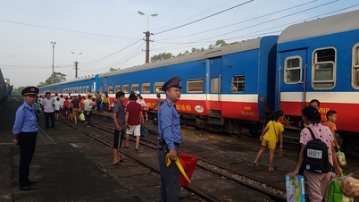
Floodwaters on the Thuong River rose high, almost touching the upper edge of the Thuong River iron bridge ( Bac Ninh ) on the morning of October 9 - Photo: HA QUAN
At 3:30 a.m. on October 9, the National Center for Hydrometeorology said that the flood on the Cau River (Thai Nguyen) at Gia Bay Station and the Trung River ( Lang Son ) at Huu Lung Station were receding. However, the flood water on the Cau River and Thuong River (Bac Ninh) was rising.
The National Center for Hydro-Meteorological Forecasting said that at 1:00 a.m. on October 9, the water level on the Thuong River at Phu Lang Thuong station reached 7.59m (1.29m above alert level 3), which exceeded the historical flood in 1986 (7.52m) by 0.07m.
In the next 12 hours, floods on Cau and Thuong rivers are likely to peak. The flood peak at Dap Cau station is about 1.1m above alert level 3.
The flood peak at Phu Lang Thuong station is about 0.18m above the historical flood in 1986.
Floods on Trung River at Huu Lung station, Cau River at Gia Bay station, Thuong River at Cau Son station continue to decrease and are above alert level 3.
According to Tuoi Tre Online , thick copper-colored floodwater has almost reached the Thuong River iron bridge in the old Bac Giang city area.
Da Mai Temple, a sacred temple in this area, was partially submerged by floodwaters.
On the shore, many people stood on the Thuong River dike from early morning because they were worried that the flood water could "swallow" the Thuong River iron bridge - the historic bridge that supplied food and weapons for the Dien Bien Phu campaign and marked the event of Uncle Ho's visit to Bac Giang province (old) in 1955.
On the morning of October 9, Bac Ninh province informed that the local authorities did not order the destruction of the dikes as information spread on the internet. The dikes were not raised to ensure flood drainage requirements, so they could overflow.
The leaders of the Provincial Civil Defense Command have directed communes and wards to have plans to evacuate people to safe places in case the dike spontaneously breaks or overflows.

Authorities have closed the road across the Thuong River iron bridge (Bac Ninh) as floodwaters are forecast to exceed historic levels - Photo: HA QUAN

The Da Mai temple area (Da Mai ward, Bac Ninh) was partially submerged in flood water - Photo: HA QUAN

Flood water rises rapidly in the Cau River area (Bac Ninh) - Photo: HA QUAN
The Center for Flood Forecasting has forecast widespread flooding in the provinces of Thai Nguyen, Bac Ninh, and Lang Son in the next 2-3 days and the risk of flooding in low-lying areas along rivers and urban areas in the Northern region. Risk of landslides on river banks and river dykes, risk of flash floods on rivers and streams, and landslides on steep slopes in the mountainous areas of the Northern region.
In the next 12 - 24 hours, floods on rivers will continue to decrease, the water level on Cau River at Gia Bay station is at alarm level 2, at Dap Cau station is about 0.5m above alarm level 3. The water level on Thuong River at Cau Son station is 1.2m above alarm level 3, at Phu Lang Thuong station is 0.7m above alarm level 3, flood on Trung River at Huu Lung station is about 3.0m above alarm level 3.
Tuoitre.vn
Source: https://tuoitre.vn/lu-tren-song-thuong-cuon-cuon-chay-vuot-moc-lich-su-nam-1986-20251009065218992.htm


![[Photo] Prime Minister Pham Minh Chinh inspects and directs the work of overcoming the consequences of floods after the storm in Thai Nguyen](https://vphoto.vietnam.vn/thumb/1200x675/vietnam/resource/IMAGE/2025/10/08/1759930075451_dsc-9441-jpg.webp)
![[Photo] Prime Minister Pham Minh Chinh attends the World Congress of the International Federation of Freight Forwarders and Transport Associations - FIATA](https://vphoto.vietnam.vn/thumb/1200x675/vietnam/resource/IMAGE/2025/10/08/1759936077106_dsc-0434-jpg.webp)


Comment (0)