
Telegrams sent to: Commands of military regions: 4, 5; military branches: Air Defense - Air Force, Navy; commands: Border Guard, Coast Guard, Artillery - Missile; military branches: Special Forces; Armored, Engineer, Communications, Chemical; army corps: 12, 34; army corps: 11, 12, 15, 16, 18, 20.
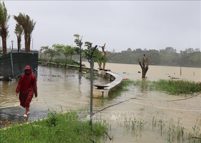
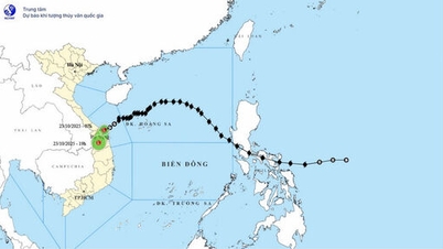
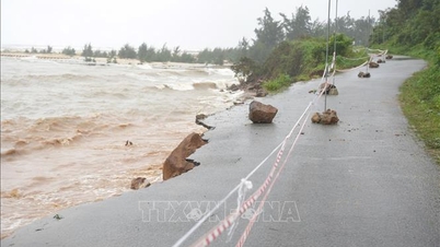
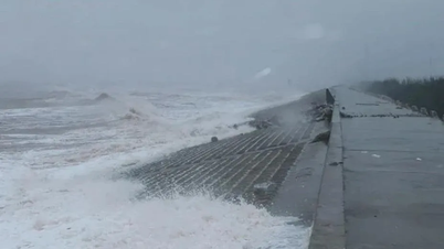
According to the bulletin of the National Center for Hydro-Meteorological Forecasting, at 7:00 a.m. on October 22, the center of storm No. 12 was located at about 17.1 degrees North latitude; 110.7 degrees East longitude, in the sea northwest of Hoang Sa special zone, about 280 km East Northeast of Da Nang city. The strongest wind near the center of the storm was level 10 (89-102 km/h), gusting to level 12.
Due to the influence of storm No. 12, there will be very heavy rain in the provinces and cities from Ha Tinh to Quang Ngai, about 200-400 mm, locally over 500 mm; in the area of South Quang Tri to Da Nang city, it will be generally 500-700 mm, locally over 900 mm. There is a high risk of flash floods and landslides in mountainous areas, flooding in low-lying areas and urban areas. Forecast level of natural disaster risk due to floods: level 3.
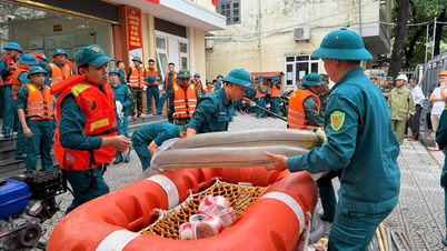
Implementing the direction of General Nguyen Tan Cuong, Chief of the General Staff of the Vietnam People's Army, Deputy Minister of National Defense , to proactively respond to storm No. 12 and heavy rain to minimize damage to life and property of the State and people, the Department of Rescue and Relief (General Staff) informed units to strictly maintain on-duty regime at all levels, grasp the weather, meteorological and hydrological situation; proactively review plans and response options, promptly and effectively handle incidents and natural disasters; ensure safety of people and vehicles for forces on duty.
Military Region 4 and Military Region 5 directed the Military Commands of provinces and cities to advise local authorities to direct departments, branches, sectors, and forces stationed in the area to inspect key areas, prepare forces, vehicles, food, and communications to be in place in areas at risk of being cut off and isolated due to landslides and floods, respond promptly, and overcome the consequences of natural disasters; coordinate with the Military Industry - Telecommunications Group (Viettel) to be ready to set up a forward command post and all other necessary assurance work to serve the Government, the Prime Minister, the Ministry of National Defense, and the General Staff to direct and direct the response to storm No. 12 and floods.
The 12th Army Corps, the 34th Army Corps and other branches and corps directed their subordinate units stationed in the areas to proactively coordinate with local Party committees and authorities where the units are stationed; prepare forces and means to be ready to respond to heavy rains, flash floods, inundation, and landslides in the area, and support people to overcome the consequences when requested by the locality.
The Navy, Border Guard Command, and Coast Guard direct units to ensure safety for vehicles operating at sea; prepare forces and vehicles to participate in search and rescue when requested. The Air Defense - Air Force, and Army Corps 18 prepare forces and aircraft to conduct search and rescue, transport goods and necessities when requested.
The Signal Corps ensures uninterrupted communication to serve the direction and operation of disaster response work, especially in isolated areas. The Special Forces Corps directs its subordinate units stationed in the area (Special Forces Brigade 5) to prepare forces and means to be ready to respond to heavy rains, flash floods, inundation, landslides, and to support people in overcoming the consequences when requested by the locality.
The Military Industry - Telecommunications Group coordinates with Military Region 4, Military Region 5 and relevant agencies to ensure transmission lines and other necessary conditions to connect the Government and the Prime Minister to hold online meetings with localities to serve the direction, operation and response to storm No. 12 and floods; be ready to send forces and vehicles (flycam) to coordinate with military regions, support localities in surveying vulnerable areas to promptly detect cracks, areas at risk of landslides, flash floods, and areas that are cut off and isolated to provide early warning and search and rescue.
Source: https://baotintuc.vn/thoi-su/quan-doi-chu-dong-ra-soat-cac-phuong-an-ung-pho-bao-so-12-va-mua-lu-20251022123814346.htm


![[Photo] Prime Minister Pham Minh Chinh chairs meeting on railway projects](https://vphoto.vietnam.vn/thumb/1200x675/vietnam/resource/IMAGE/2025/10/23/1761206277171_dsc-9703-jpg.webp)
![[Photo] Prime Minister Pham Minh Chinh meets with South African President Matamela Cyril Ramaphosa](https://vphoto.vietnam.vn/thumb/1200x675/vietnam/resource/IMAGE/2025/10/23/1761226081024_dsc-9845-jpg.webp)

![[Photo] President Luong Cuong holds talks with South African President Matamela Cyril Ramaphosa](https://vphoto.vietnam.vn/thumb/1200x675/vietnam/resource/IMAGE/2025/10/23/1761221878741_ndo_br_1-8416-jpg.webp)


Comment (0)