

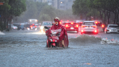
The 2025 storm season recorded rare extreme numbers in terms of intensity, frequency and range of influence - Illustration photo
This is the information given by Deputy Director of the Department of Hydrometeorology ( Ministry of Agriculture and Environment ) Hoang Duc Cuong at the regular press conference of the Ministry of Agriculture and Environment on October 6.
According to Mr. Hoang Duc Cuong, from now until the end of 2025, ENSO (a phenomenon that refers to both El Nino and La Nina, related to the oscillation of air pressure between the two shores of the Eastern Pacific Ocean and the Eastern Indian Ocean) is likely to remain in a neutral state and lean towards the cold phase, but has not yet reached a La Nina cycle.
With the above meteorological trend, from October to December 2025, storms and tropical depressions operating in the East Sea and affecting our country are likely to be at a higher level than the average of many years (during this period, on average in many years, there are 4.5 storms in the East Sea; of which 1.9 storms make landfall).
No information has been recorded regarding storm number 12.
Regarding information on social networks about storm No. 12 (international name is storm Ha Long), which is expected to appear right after storm No. 11 (storm MATMO), Mr. Cuong said that currently, the forecasting system has not received information related to storm No. 12.
"There will definitely be storm number 12 in the East Sea, because there will still be storms from now until the end of the year. However, at present, we do not see any conditions for storm number 12 to appear in the East Sea," Mr. Cuong emphasized.
For more information, Mr. Cuong said that recently on social networks there was also information that there was a storm right after storm No. 11 (storm MATMO). However, this is storm No. 22 in the Northwest Pacific and is named right after the name provided by Vietnam, Ha Long. Therefore, many people mistakenly think that storm Ha Long is storm No. 12.
"However, this storm did not enter the East Sea so it is not storm number 12 as reported on social media," Mr. Cuong added.
Cold weather in the North is likely to appear from the second half of December.
Regarding cold air and severe cold, Mr. Hoang Duc Cuong said that from around October 2025, cold air tends to increase in intensity and frequency. It is forecasted that cold air will be active in November-December 2025.
Notably, severe cold in the North is likely to appear from the second half of December (similar to the average of many years).
Also in the forecast period from now until the end of 2025, heavy rains are likely to appear in the Central region. During this period, the peak of the storm season and heavy rains will be concentrated in the area from Ha Tinh to Hue and the eastern region of the provinces from Quang Ngai to Khanh Hoa from October to the first half of December 2025.
Regarding the hydrological sector, Mr. Cuong said that from October to December 2025, on rivers from Quang Tri to Khanh Hoa and Lam Dong, the flood peak will generally be at alert level 2-3, in some places exceeding alert level 3. Large floods are likely to be concentrated in October and November 2025 and there is a possibility of late floods appearing at the end of the year coinciding with the water accumulation period of the inter-reservoir operation processes of rivers in the Central region.
Mr. Hoang Duc Cuong noted that with the above trend, the risk of flooding in urban areas and large cities continues to occur due to the impact of local heavy rains. Flash floods and landslides are at high risk in mountainous provinces.
Recording unusual natural disaster patterns
Further assessing the natural disaster situation, Deputy Director of the Department of Hydrometeorology Hoang Duc Cuong said that in the first 9 months of 2025, natural disasters have developed in a complex, unusual and more extreme manner than the average of many years. In particular, natural disasters are concentrated with a high level of danger in the Northern, North Central and Central Central regions, showing a clear trend of seasonal shifts in natural disasters (extreme rains not only occur in the rainy season but also in the dry season).
Natural disasters occur with fierce intensity and have a wide range of impacts.
The 2025 storm season has recorded rare extreme numbers in terms of intensity, frequency and scope of influence. In just the past 9 months, the East Sea has seen 14 storms and tropical depressions, much higher than the average of many years. Of these, 6 storms have directly and indirectly affected our country, creating a series of natural disasters, with almost no break long enough to overcome the consequences.
As early as June, storm No. 1 (WUTIP), the first storm to appear in the East Sea in more than 40 years. Mr. Cuong said that although storm No. 1 did not make landfall, its circulation caused record rainfall of 250-550 mm from South Ha Tinh to Da Nang, in many places exceeding 800 mm, leading to historic floods on the rivers of the Central region.
Just over a month later, storms No. 3 and No. 5 made landfall consecutively, causing winds of level 10-11, gusts of level 12, rain of 200-400 mm, in some places over 500 mm, causing floods exceeding alert level 3 on the Ca, Ma, Hoang Long, Thao river systems...
Next, super typhoon No. 9 (RAGASA) appeared in the East Sea in late September. Mr. Cuong emphasized that the strongest intensity of super typhoon RAGASA was assessed by international typhoon forecasting centers to be stronger than super typhoon YAGI in 2024.
"For the first time in forecasting history, Vietnam has determined that the storm's wind level has reached level 17, with gusts above level 17. Super typhoon RAGASA has become the strongest super typhoon ever recorded in the East Sea. Although it weakened before reaching the shore, it shows the real risk of super typhoons in the context of climate change," Mr. Cuong analyzed.
Notably, right after storm No. 9, storm No. 10 (BUALOI) made landfall directly in the Ha Tinh and Northern Quang Tri regions with wind speeds of level 10-12, gusts of level 14, and widespread rain of 300-600 mm, causing widespread flooding, landslides, and flash floods from the North to the Central regions.
Storm No. 10 is identified as a storm with many unusual and extreme features, with a series of manifestations such as: Moving speed is twice as fast as normal storms; the storm's stay on land in the provinces of Nghe An - Northern Quang Tri is rarely longer than 12 hours; strong storm wind circulation from level 6 or higher spreads across 11/21 coastal provinces.
"In particular, despite being hundreds of kilometers away from the storm's center, from dawn to noon on September 29, several northern provinces recorded tornadoes and waterspouts causing great damage to people and property," Mr. Cuong added.
Not only storms, in the past 9 months, the whole country has also experienced 14 large-scale heavy rains, including 2 unseasonal rains in the Northern and Central Central regions. In particular, the rain from the night of May 22-24 in Ha Tinh has observed 29/103 stations with over 200 mm, 13/103 stations with over 300 mm and 7/103 stations with over 400 mm.
During storm No. 5, the rain from the night of August 24 to the morning of August 27 in the provinces of the Northern Delta and midlands, Thanh Hoa to Northern Quang Tri had heavy to very heavy rain with common rainfall from 200-400 mm, in some places rainfall over 500 mm. This flood caused many flash floods, landslides and serious inundation in the mountainous provinces and midlands of the North, as well as along the coastal strip of the North Central region.
Notably, the recent storm No. 10 caused heavy rains throughout the North and Thanh Hoa to Hue City. On September 30, the Hanoi area recorded very heavy rains.
Thu Cuc
Source: https://baochinhphu.vn/thien-tai-nam-2025-co-xu-huong-cuc-doan-hon-so-voi-trung-binh-nhieu-nam-102251006151314108.htm


Comment (0)