

Forecast of location and direction of storm Matmo (Photo: NCHMF)
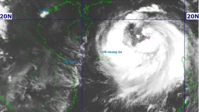
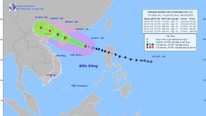
According to the National Center for Hydro-Meteorological Forecasting, at 9:00 a.m. on October 4, the center of storm Matmo was in the eastern sea of the northern East Sea, about 450km east-northeast of Hoang Sa special zone.
The storm is maintaining level 11 (103-117km/h), gusting to level 14 and is moving rapidly in a west-northwest direction at a speed of about 25km/h.
This morning, the Vietnam Meteorological Agency issued an emergency storm warning for storm Matmo.
Tomorrow evening, storm Matmo enters the Gulf of Tonkin.
It is forecasted that in the next 24 hours, the storm will move quickly and its intensity may increase by two levels, to level 13 (134-149km/h), gusting to level 16.
Around noon tomorrow evening, storm Matmo will enter the Gulf of Tonkin and in the early morning of October 6, the storm is likely to make landfall in the Northeast region.
The meteorological agency said that when entering the Gulf of Tonkin, the storm may weaken compared to its peak intensity, the degree of reduction will depend on the direction of the storm's movement. If the storm deviates to the north, it may weaken 2-4 levels compared to its peak intensity.
If the storm moves further west - meaning more over sea - the impact on rain and wind will be greater.
Due to the storm's influence, in the North East Sea area, there are strong winds of level 8-10, near the storm's eye level 11-13, gusts of level 16, waves 4-6m high, near the storm's eye 6-8m, rough seas.
From the afternoon of October 5, the sea area east of the northern Gulf of Tonkin (including Bach Long Vi special zone) will have winds gradually increasing to level 6-7, then increasing to level 8-9.
From the evening of October 5, the northern area of Bac Bo Gulf (including Bach Long Vy, Van Don, Co To, Cat Hai and Hon Dau islands) will have winds gradually increasing to level 8-9, waves 2-4m high, near the storm center will have winds of level 10-11, gusts of level 14, waves 3-5m high, and very rough seas.
Coastal areas and islands in Quang Ninh - Hai Phong provinces have storm surges of 0.4-0.6m. Beware of flooding in low-lying coastal areas and river mouths due to surges and big waves from the afternoon and evening of October 5.
Quang Ninh to Ninh Binh is likely to have strong winds of level 9-10 near the storm center.
On land from the night of October 5, on land from Quang Ninh to Ninh Binh, winds will gradually increase to level 6-8, near the storm's eye level 9-10 - winds that can knock down trees, houses, and electric poles, causing very heavy damage.
Inland areas in the Northeast have strong winds of level 6, some places level 7, gusting to level 8-9.
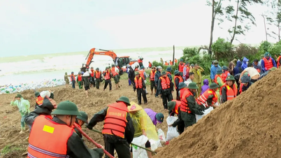
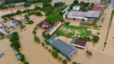
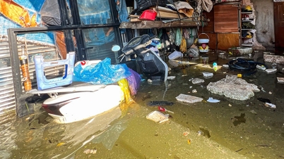
From the night of October 5 to the end of the night of October 7, in the Northern region, Thanh Hoa and Nghe An, there will be heavy to very heavy rain with common rainfall of 100-200mm, locally over 300mm.
In the mountainous and midland areas of the North, the average temperature is from 150-250mm, locally over 400mm.
Warning of the risk of heavy rain over 200mm in 3 hours causing flooding in low-lying areas, urban and industrial areas, flash floods on small rivers and streams, and landslides in mountainous areas./.
According to Tuoi Tre Newspaper
Source: https://tuoitre.vn/bao-matmo-di-nhanh-du-bao-tac-dong-mua-gio-khi-do-bo-rang-sang-6-10-20251004064608869.htm
Source: https://baolongan.vn/bao-matmo-di-nhanh-du-bao-tac-dong-mua-gio-khi-do-bo-rang-sang-06-10-a203755.html
![[Photo] Solemn opening of the 8th Congress of the Central Public Security Party Committee, term 2025-2030](https://vphoto.vietnam.vn/thumb/1200x675/vietnam/resource/IMAGE/2025/10/4/f3b00fb779f44979809441a4dac5c7df)


![[Photo] General Secretary To Lam attends the 8th Congress of the Central Public Security Party Committee](https://vphoto.vietnam.vn/thumb/1200x675/vietnam/resource/IMAGE/2025/10/4/79fadf490f674dc483794f2d955f6045)


![[Photo] Students of Binh Minh Primary School enjoy the full moon festival, receiving the joys of childhood](https://vphoto.vietnam.vn/thumb/1200x675/vietnam/resource/IMAGE/2025/10/3/8cf8abef22fe4471be400a818912cb85)
![[Infographic] Notable numbers after 3 months of "reorganizing the country"](https://vphoto.vietnam.vn/thumb/1200x675/vietnam/resource/IMAGE/2025/10/4/ce8bb72c722348e09e942d04f0dd9729)


Comment (0)