
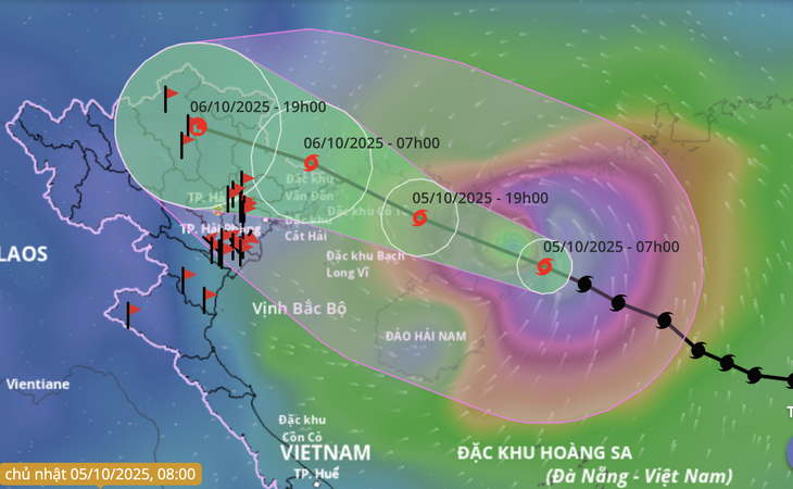
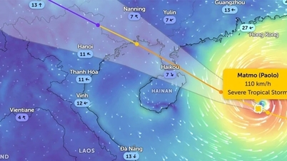
Forecast of location and direction of storm Matmo at 7am on October 5 - Photo: VNDMS
According to the National Center for Hydro-Meteorological Forecasting at 8:00 a.m. on October 5, the center of storm Matmo was about 400km east-southeast of Mong Cai ( Quang Ninh ). The strongest wind near the center of the storm was level 12-13 (118-149km/h), gusting to level 15.
Storm Matmo is likely to weaken as it enters the Gulf of Tonkin.
It is forecast that this afternoon, storm Matmo will make landfall on Leizhou peninsula (China) and then enter the Gulf of Tonkin.
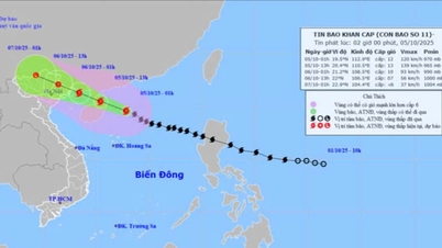
At 7:00 p.m. tonight, the storm center is in the eastern sea of the northern Gulf of Tonkin, about 190km east-southeast of Quang Ninh, the storm intensity is currently level 12 (118-134km/h), gusting to level 15.
Tonight until tomorrow morning, the storm will continue to move west-northwest and make landfall in Quang Ninh (Vietnam) - Guangxi (China), with the intensity likely to weaken further.
At 7am tomorrow morning, the storm center will be on the border area of Quang Ninh (Vietnam) - Guangxi (China), the storm intensity will have decreased to level 9, gusting to level 12.
The storm then moved inland and gradually weakened into a tropical depression and then a low pressure area over the mountainous region of the North.
Due to the influence of storm Matmo, the northwestern sea of the North East Sea has strong winds of level 8-10, the area near the storm's eye has winds of level 11-13, gusts of level 15-16, waves 4-6m high, the area near the storm's eye has waves of 6-8m, and the sea is very rough.
From the afternoon of October 5, the sea area east of the northern Gulf of Tonkin (including Bach Long Vi special zone) will have winds gradually increasing to level 6-7, then increasing to level 8-9.
From the evening of October 5, the northern area of Bac Bo Gulf (including Bach Long Vi, Van Don, Co To, Cat Hai and Hon Dau islands) will have winds gradually increasing to level 8-10, waves 2-4m high, the area near the storm center will have winds of level 11-12, gusts of level 15, waves 3-5m high, and rough seas.
Coastal areas and islands in Quang Ninh - Hai Phong provinces will have storm surges of 0.4-0.6m. Beware of flooding in low-lying coastal areas and river mouths due to surges and big waves from the afternoon and evening of October 5th.
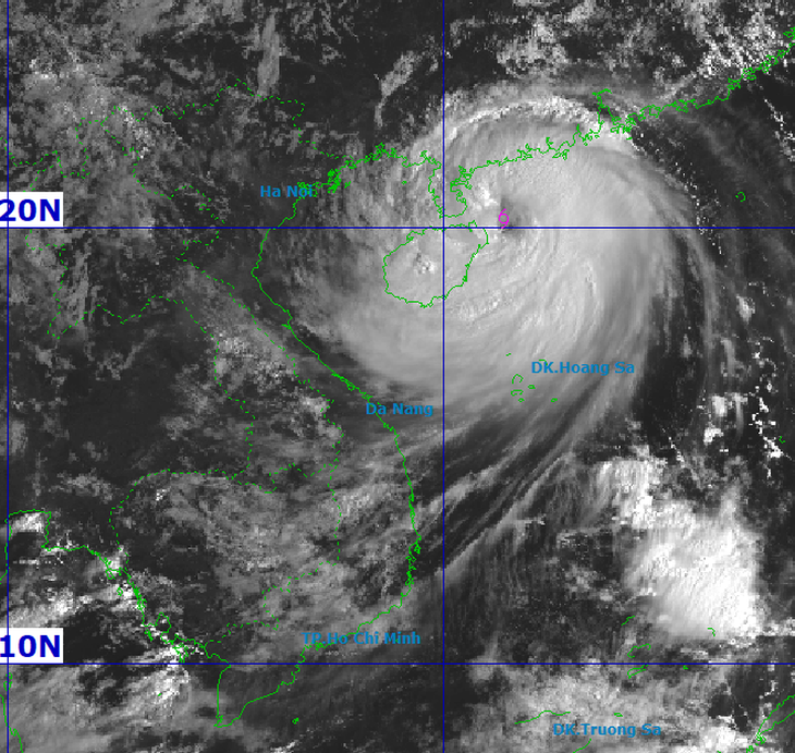
From the satellite image at 8am this morning, storm Matmo can be clearly seen - Photo: NCHMF
Quang Ninh and Hai Phong coastal areas are likely to have winds from level 8-10, gusting to level 10-13.
From tonight until noon on October 6, on land in coastal areas from Quang Ninh to Hung Yen and Lang Son province, winds will gradually increase to level 6-7, near the storm's eye level 8-10, gusting to level 11-12.
Inland areas in the Northeast have strong winds of level 4-5, in some places level 6, gusting to level 7-8.
Communes/wards in the northeastern region of Quang Ninh province are likely to have strong storm winds of level 9-10, gusting to level 12-13.
The remaining communes and wards of Quang Ninh province and coastal areas of Hai Phong are likely to have strong storm winds of level 8-9, gusting to level 10-11.
Coastal communes and wards of Hung Yen province and northern border communes of Lang Son province are likely to have strong storm winds of level 6-8, gusting to level 9-10.
The northeastern area of Bac Ninh province (formerly Bac Giang province) is likely to have strong storm winds of level 6-7, gusting to level 8-9.
From tonight until the end of the night of October 7, mountainous and midland areas of the North will have heavy rain, with average rainfall from 150-250mm, and locally very heavy rain over 400mm.
The Northern Delta region and Thanh Hoa have moderate to heavy rain with common rainfall of 70-150mm, locally very heavy rain over 200mm.
Due to the influence of the wide storm circulation, it is necessary to guard against the risk of thunderstorms, tornadoes and strong gusts of wind both before and during the storm's landfall.
At the same time, heavy rain of over 150mm in 3 hours caused flooding in low-lying areas, urban areas and flash floods and landslides in mountainous areas.
Hanoi area is less likely to be affected by storms, need to be on guard against thunderstorms, tornadoes and strong gusts. It is forecasted that from early tomorrow morning (October 6) to the end of October 7, there will be moderate to heavy rain, with common rainfall of 70-120mm, locally over 150mm.
Source: https://tuoitre.vn/bao-matmo-manh-len-dau-cap-13-giat-cap-16-gay-mua-gio-the-nao-den-nuoc-ta-20251005084742257.htm


![[Photo] Bustling Mid-Autumn Festival at the Museum of Ethnology](https://vphoto.vietnam.vn/thumb/1200x675/vietnam/resource/IMAGE/2025/10/4/da8d5927734d4ca58e3eced14bc435a3)


![[Photo] Solemn opening of the 8th Congress of the Central Public Security Party Committee, term 2025-2030](https://vphoto.vietnam.vn/thumb/1200x675/vietnam/resource/IMAGE/2025/10/4/f3b00fb779f44979809441a4dac5c7df)
![[Photo] General Secretary To Lam attends the 8th Congress of the Central Public Security Party Committee](https://vphoto.vietnam.vn/thumb/1200x675/vietnam/resource/IMAGE/2025/10/4/79fadf490f674dc483794f2d955f6045)


![[VIDEO] Summary of Petrovietnam's 50th Anniversary Ceremony](https://vphoto.vietnam.vn/thumb/402x226/vietnam/resource/IMAGE/2025/10/4/abe133bdb8114793a16d4fe3e5bd0f12)

![[VIDEO] GENERAL SECRETARY TO LAM AWARDS PETROVIETNAM 8 GOLDEN WORDS: "PIONEER - EXCELLENT - SUSTAINABLE - GLOBAL"](https://vphoto.vietnam.vn/thumb/402x226/vietnam/resource/IMAGE/2025/7/23/c2fdb48863e846cfa9fb8e6ea9cf44e7)


Comment (0)