
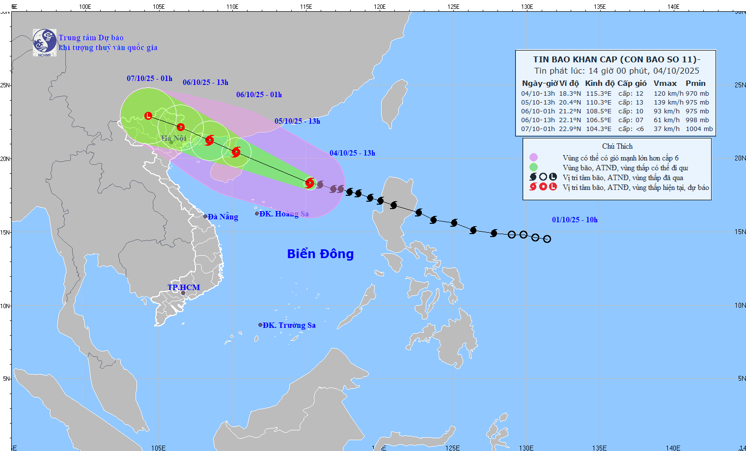
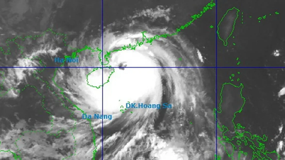
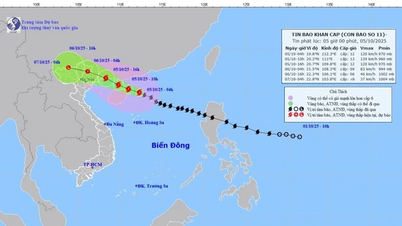
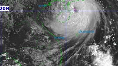
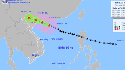
Specifically, at 2:00 p.m. on October 4, the center of the storm was at about 18.4 degrees North latitude; 115.1 degrees East longitude, about 330km East Northeast of Hoang Sa special zone. The strongest wind near the center of the storm was level 12 (118-133km/h), gusting to level 15. The storm moved in a West Northwest direction, at a speed of about 25km/h.
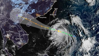
As of 1 p.m. on October 5, the storm is moving west-northwest at a speed of 20-25 km/h and is likely to intensify. The center of the storm is located in the sea east of Leizhou Peninsula (China). The storm intensity is level 12-13, gusting to level 16. The disaster risk level is level 3, the affected area is the North East Sea.
At 1:00 a.m. on October 6, the storm continued to move in the West-Northwest direction, at a speed of about 20km/h, entering the northern area of the Gulf of Tonkin and gradually weakening. The center of the storm was located in the sea area of Quang Ninh - Hai Phong . The storm intensity was level 9-10, gusting to level 13. The natural disaster risk level was level 3, affecting the northwestern sea area of the North East Sea, the northern sea area of the Gulf of Tonkin and the coastal mainland area from Quang Ninh to Hung Yen.
At 1 p.m. on October 6, the storm moved in the West Northwest direction at a speed of about 20 km/h, entered the mainland and gradually weakened. The center of the storm was located on the Vietnam - China border area. The storm intensity was level 7, gusting to level 9. The natural disaster risk level was level 3, affecting the northern sea area of the Gulf of Tonkin and the coastal mainland area from Quang Ninh to Hung Yen .
At 1am on October 7, the storm continued to move west-northwest at a speed of 15-20km/h, entering the western mountainous region of the North. At this time, the wind intensity decreased to below level 6.
Due to the storm's influence, the North East Sea has strong winds of level 8-10, the area near the storm's eye has strong winds of level 11-13, gusting to level 16; waves are 4-6m high, the area near the storm's eye is 6-8m; the sea is very rough, the destructive power is extremely large, and can sink even large ships.
From the afternoon of October 5, the sea area east of the Northern Gulf of Tonkin (including Bach Long Vi special zone) has strong winds of level 6-7, then increasing to level 8-9. From the evening of October 5, the Northern Gulf of Tonkin area (including Bach Long Vi, Van Don, Co To, Cat Hai and Hon Dau island) has strong winds of level 8-9, waves 2-4m high; the area near the storm center has strong winds of level 10-11, gusts of level 14, waves 3-5m high; the sea is rough, extremely dangerous for ships.
Coastal areas and islands in Quang Ninh - Hai Phong have storm surges of 0.4-0.6m. There is a risk of flooding in low-lying coastal areas and river mouths from the afternoon to the evening of October 5.
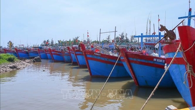
Warning: Weather conditions at sea and in coastal areas during the storm are extremely dangerous, making it unsafe for any vehicle or structure in the danger zone, including cruise ships, passenger ships, cargo ships, cages, aquaculture areas, dykes and coastal routes. Vehicles are at high risk of capsizing and being destroyed; there is also a high risk of flooding due to strong winds, large waves and rising sea levels.
On land, from the night of October 5, coastal areas from Quang Ninh to Hung Yen will see winds gradually increasing to level 6-7, and near the storm's eye, winds will reach level 8-9, gusting to level 10-11. Winds can break tree branches, blow off roofs, and cause damage to buildings and houses. Inland areas in the Northeast will see strong winds of level 4-5, in some places level 6, gusting to level 7-8.
From the night of October 5 to the end of the night of October 7, mountainous and midland areas of the North will have heavy rain, with average rainfall of 150-250mm, and locally over 400mm. There is a risk of heavy rain with an intensity of over 150mm in 3 hours.
The Northern Delta and Thanh Hoa regions have moderate to heavy rain with common rainfall of 70-150mm, locally over 200mm.
The Hanoi area is unlikely to be directly affected by the storm. However, it is forecasted that from early morning on October 6 to the end of October 7, there will be moderate to heavy rain, with average rainfall of 70-120mm, and locally over 150mm.
Due to the influence of the wide storm circulation, it is necessary to guard against the risk of thunderstorms, tornadoes and strong gusts of wind both before and during the storm's landfall.
Source: https://baotintuc.vn/kinh-te/bao-so-11-manh-them-1-cap-cach-dac-khu-hoang-sa-khoang-330km-20251004144903722.htm

![[Photo] Prime Minister Pham Minh Chinh launched a peak emulation campaign to achieve achievements in celebration of the 14th National Party Congress](https://vphoto.vietnam.vn/thumb/1200x675/vietnam/resource/IMAGE/2025/10/5/8869ec5cdbc740f58fbf2ae73f065076)


![[Photo] General Secretary To Lam attends the 8th Congress of the Central Public Security Party Committee](https://vphoto.vietnam.vn/thumb/1200x675/vietnam/resource/IMAGE/2025/10/4/79fadf490f674dc483794f2d955f6045)
![[Photo] Bustling Mid-Autumn Festival at the Museum of Ethnology](https://vphoto.vietnam.vn/thumb/1200x675/vietnam/resource/IMAGE/2025/10/4/da8d5927734d4ca58e3eced14bc435a3)
![[Photo] Solemn opening of the 8th Congress of the Central Public Security Party Committee, term 2025-2030](https://vphoto.vietnam.vn/thumb/1200x675/vietnam/resource/IMAGE/2025/10/4/f3b00fb779f44979809441a4dac5c7df)


![[VIDEO] Summary of Petrovietnam's 50th Anniversary Ceremony](https://vphoto.vietnam.vn/thumb/402x226/vietnam/resource/IMAGE/2025/10/4/abe133bdb8114793a16d4fe3e5bd0f12)

![[VIDEO] GENERAL SECRETARY TO LAM AWARDS PETROVIETNAM 8 GOLDEN WORDS: "PIONEER - EXCELLENT - SUSTAINABLE - GLOBAL"](https://vphoto.vietnam.vn/thumb/402x226/vietnam/resource/IMAGE/2025/7/23/c2fdb48863e846cfa9fb8e6ea9cf44e7)


Comment (0)