

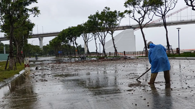
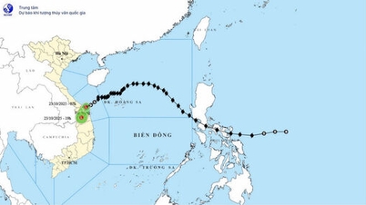
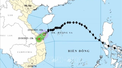
The National Center for Hydro-Meteorological Forecasting informed that last night (October 22), storm No. 12 weakened into a tropical depression while moving into the central sea.
At 1am this morning (October 23), the center of the tropical depression was located on the sea from South Quang Tri to Quang Ngai, about 80km east-northeast of Da Nang city. The strongest wind near the center of the tropical depression was level 6 (39-49km/h), gusting to level 8. Currently, the tropical depression is still moving steadily in the southwest direction at a speed of 10-15km/h.
The National Center for Hydro-Meteorological Forecasting said that this morning to this afternoon, the tropical depression will move inland. By 1 p.m., the center of the tropical depression will be on land from Da Nang City to Quang Ngai Province and continue to weaken into a low pressure area, with wind intensity decreasing below level 6.
According to the forecast model of the Joint Typhoon Warning Center (JTWC - USA), at about 7:00 a.m. this morning (Vietnam time), the center of the tropical depression was about 40-60km from the coast of Hue - Da Nang.
 updated at nearly 7:00 a.m. this morning")
The meteorological agency warned that today, due to the influence of a tropical depression combined with cold air, the sea area from Quang Tri to Quang Ngai (including Con Co special zone, Cu Lao Cham island and Ly Son special zone) will have strong winds of level 6, gusting to level 8.
Coastal areas from South Quang Tri to Da Nang City have water levels rising 0.3-0.6m due to strong winds. Coastal areas and river mouths from South Quang Tri to Da Nang need to be on guard against large waves combined with high tides and rising water levels causing flooding in low-lying areas, waves overflowing coastal and riverside roads, and coastal erosion. All ships, boats, and aquaculture areas in the above-mentioned dangerous areas are likely to be affected by storms, whirlwinds, strong winds, large waves, and rising sea levels.
The National Center for Hydro-Meteorological Forecasting continues to warn of the risk of rain and floods due to storm circulation (tropical depression). From today until the night of October 24, the area from Ha Tinh to Quang Ngai will have heavy rain, with the focus on very heavy rain from South Quang Tri to Da Nang with an amount of 200-400mm, in some places over 700mm.
Source: https://www.sggp.org.vn/bao-so-12-da-suy-yeu-thanh-ap-thap-nhiet-doi-post819429.html
![[Photo] General Secretary To Lam and his wife begin their official visit to Bulgaria](https://vphoto.vietnam.vn/thumb/1200x675/vietnam/resource/IMAGE/2025/10/23/1761174468226_tbtpn5-jpg.webp)
![[Photo] Comrade Nguyen Duy Ngoc visited and worked at SITRA Innovation Fund and ICEYE Space Technology Company](https://vphoto.vietnam.vn/thumb/1200x675/vietnam/resource/IMAGE/2025/10/23/1761174470916_dcngoc1-jpg.webp)


![[Photo] Award Ceremony of the Political Contest on Protecting the Party's Ideological Foundation](https://vphoto.vietnam.vn/thumb/1200x675/vietnam/resource/IMAGE/2025/10/22/1761151665557_giaia-jpg.webp)
![[Photo] Da Nang: Shock forces protect people's lives and property from natural disasters](https://vphoto.vietnam.vn/thumb/1200x675/vietnam/resource/IMAGE/2025/10/22/1761145662726_ndo_tr_z7144555003331-7912dd3d47479764c3df11043a705f22-3095-jpg.webp)


Comment (0)