
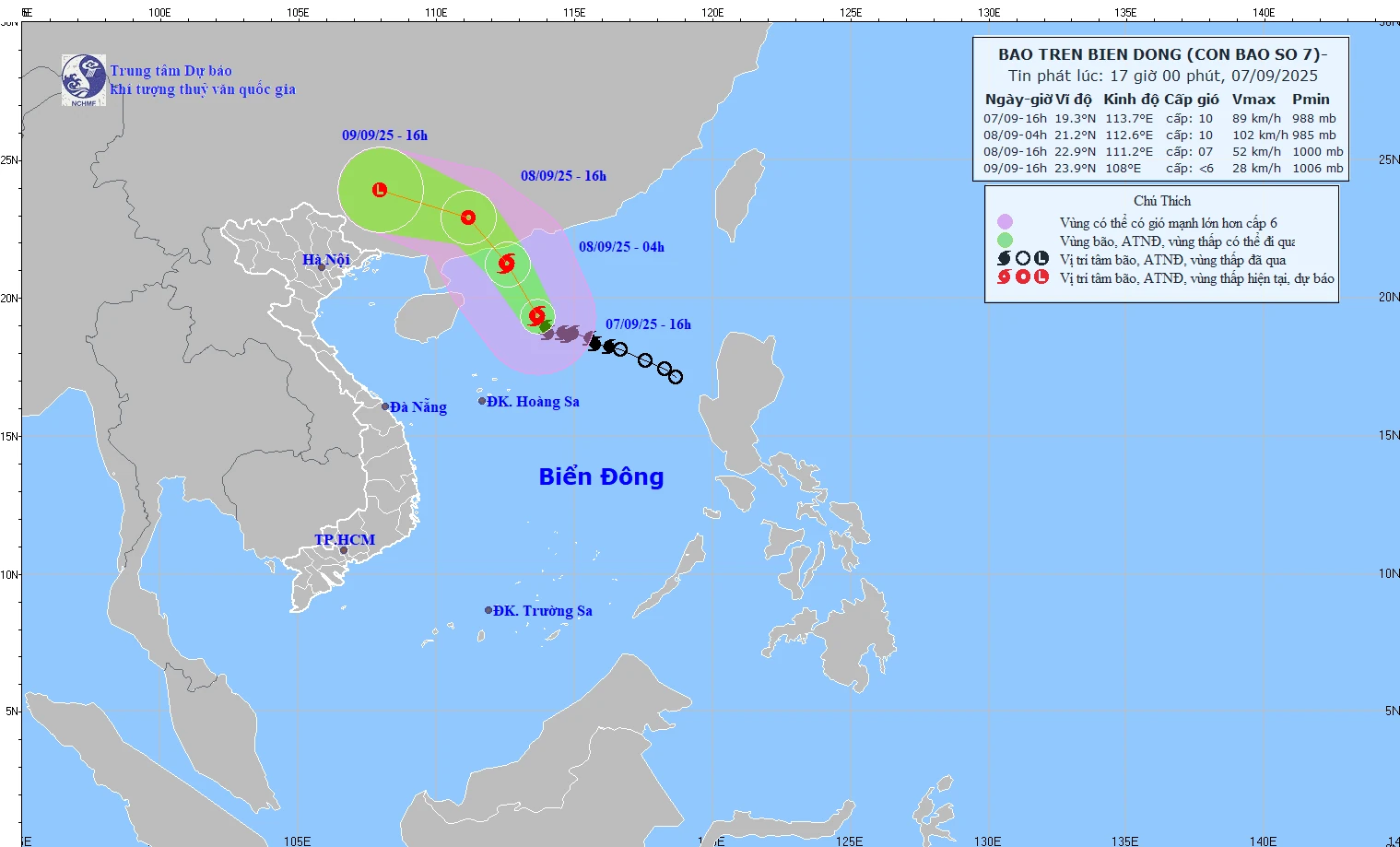
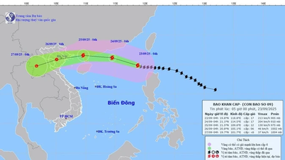
Forecast map of storm trajectory and intensity at 5:00 p.m. on September 7, 2025. (Photo: KTTV)
According to the National Center for Hydro-Meteorological Forecasting, At 4:00 p.m. on September 7, the storm center was at about 19.3 degrees North latitude - 113.7 degrees East longitude, in the northern sea area of the North East Sea. The strongest wind near the storm center was level 9-10 (75-102 km/h), gusting to level 13. Moving northwest at a speed of about 10-15 km/h.
Storm forecast:
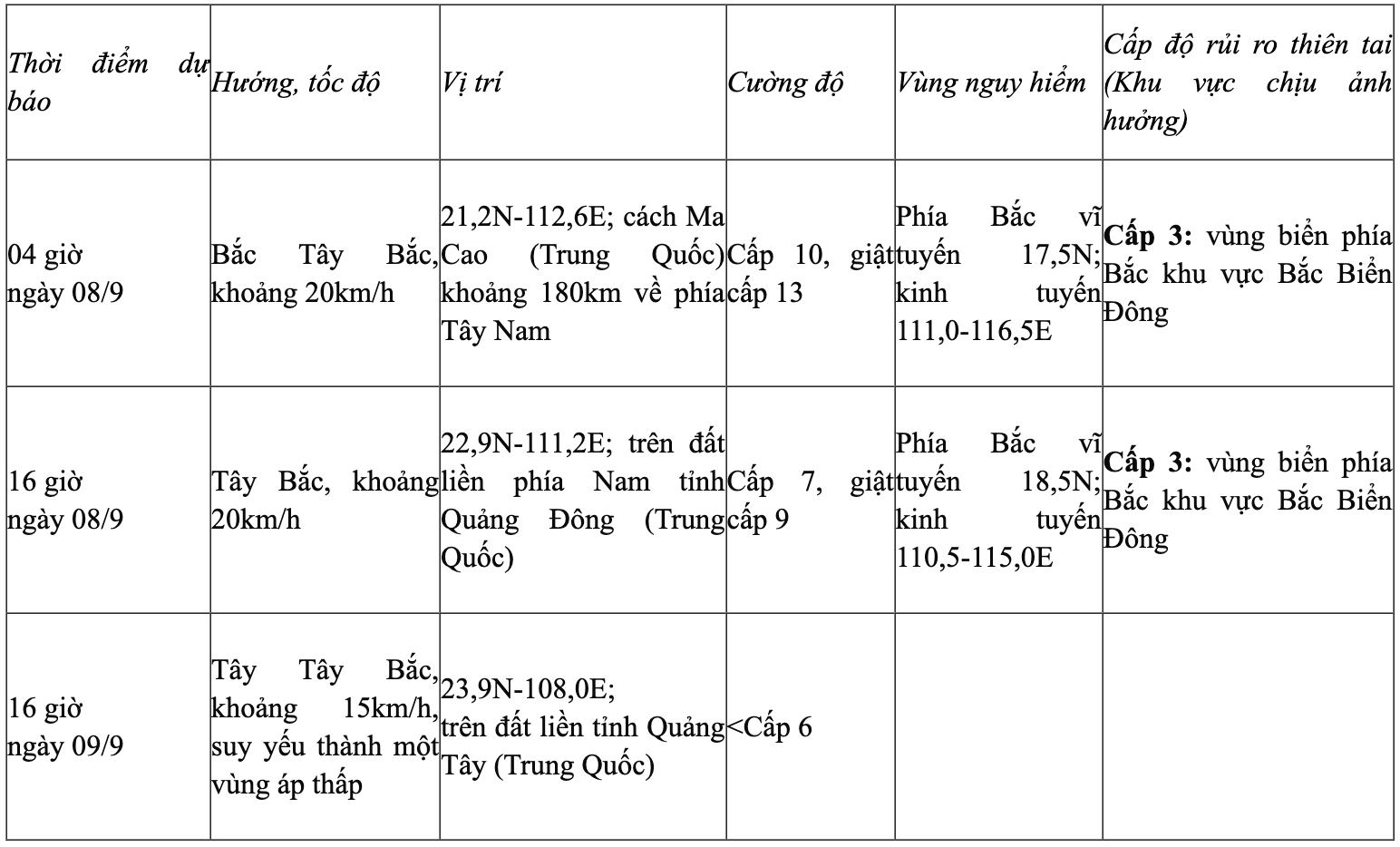
Due to the influence of the storm, the northern sea area of the North East Sea has strong winds of level 7-8, near the storm center level 9-10, gusting to level 13. Waves are 4-6m high, the sea is very rough.
Vessels operating in the above mentioned dangerous areas are susceptible to the impact of storms, whirlwinds, strong winds and large waves.
Although not directly affected by the storm circulation, areas on the far edge of the storm circulation such as the Gulf of Tonkin and the eastern coastal areas of the North may experience thunderstorms, tornadoes and strong gusts of wind.
From September 9 to the night of September 10, the mountainous and midland areas of the North are likely to experience widespread heavy rain, with rainfall ranging from 70-150mm in general and over 300mm in some places. There is a risk of heavy rain (>100mm/3 hours). During thunderstorms, there is a possibility of tornadoes, lightning, hail and strong gusts of wind.
NM
Source: https://baothanhhoa.vn/cac-khu-vuc-o-ria-xa-hoan-luu-bao-so-7-co-the-xuat-hien-dong-loc-gio-giat-manh-260831.htm


![[Photo] Hanoi morning of October 1: Prolonged flooding, people wade to work](https://vphoto.vietnam.vn/thumb/1200x675/vietnam/resource/IMAGE/2025/10/1/189be28938e3493fa26b2938efa2059e)


![[Photo] Panorama of the cable-stayed bridge, the final bottleneck of the Ben Luc-Long Thanh expressway](https://vphoto.vietnam.vn/thumb/1200x675/vietnam/resource/IMAGE/2025/9/30/391fdf21025541d6b2f092e49a17243f)
![[Photo] The 1st Congress of Phu Tho Provincial Party Committee, term 2025-2030](https://vphoto.vietnam.vn/thumb/1200x675/vietnam/resource/IMAGE/2025/9/30/1507da06216649bba8a1ce6251816820)
![[Photo] President Luong Cuong receives President of the Cuban National Assembly Esteban Lazo Hernandez](https://vphoto.vietnam.vn/thumb/1200x675/vietnam/resource/IMAGE/2025/9/30/4d38932911c24f6ea1936252bd5427fa)


Comment (0)