
On the morning of October 10, the Hanoi Department of Construction said that the flooding situation in Trung Gia area continues to remain high and has not receded to the present time.
National Highway 3 is flooded 0.5 - 1m at Km28 and Km29.
Road 35 is flooded 0.5-1.3m at locations Km0+300 - Km0+700 (Tu Tao bridge), Km2 - Km2+500.
Road 16 flooded 0.5 - 1m at Km2+100 - Km2+400.
Hong Ky - Bac Son road through Cau Chien bridge is flooded 0.8 - 1.3m.
Road 401 flooded ~0.5m due to river overflow.
The road management unit coordinates with relevant units to place warnings and arrange traffic guides at sections of roads where vehicles cannot pass.
Hanoi Department of Construction advises vehicles to limit their travel through deeply flooded areas from Hanoi to Thai Nguyen . The Department is surveying non-flooded routes to have a plan for remote traffic guidance.
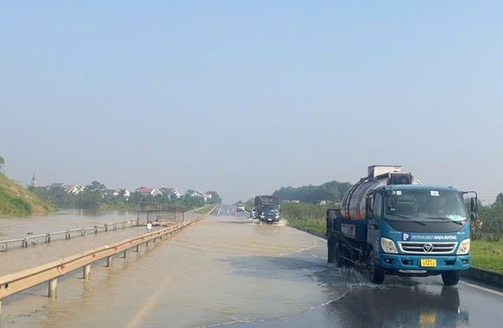
On the same day, Traffic Police Department Hanoi police said the flooding situation on the Hanoi - Thai Nguyen highway continues to be complicated. Water levels in some areas are higher than last night and many types of car unable to move
Specifically, at Km9, the water was 45cm deep and 50m long, allowing high-chassis vehicles, trucks, and passenger cars to move. Meanwhile, 5-seat sedans could not pass. Police instructed sedans from Thai Nguyen to Hanoi to go through Yen Binh overpass - Phuong Tre intersection - turn right to Xuan Cam bridge - Bac Phu intersection. Similarly, around Km29 of this highway (Hanoi - Thai Nguyen direction) there was also about 40cm of flooding.
Meanwhile, on National Highway 3, section Km28+100, there was 30-35 cm of flooding, making it difficult for vehicles to move; Km29+500; Km31, the water was so deep that vehicles could not move.
Traffic Police Team No. 15 has set up warning signs and dispatched officers to direct and regulate traffic. Authorities advise drivers to reduce speed when passing through flooded areas and to follow traffic police instructions. At the same time, traffic police advise absolutely not to attempt to cross deeply flooded areas.
The Northern Hydrometeorological Station warns that floods on the Cau and Ca Lo rivers are at very high levels. The flooding may last 1-4 days, and in some places longer. Floods, especially large floods, also threaten the safety of key dykes, underground dykes, spillways, bridges, culverts and roads in many riverside communes, such as: Trung Gia, Da Phuc, Soc Son, Thu Lam, Phuc Thinh, Quang Minh, Tien Thang, Noi Bai.
Source: https://baolangson.vn/nuoc-lu-sau-toi-1-3m-o-to-khong-the-di-vao-cao-toc-ha-noi-thai-nguyen-5061493.html

![[Photo] Ho Chi Minh City is brilliant with flags and flowers on the eve of the 1st Party Congress, term 2025-2030](https://vphoto.vietnam.vn/thumb/1200x675/vietnam/resource/IMAGE/2025/10/10/1760102923219_ndo_br_thiet-ke-chua-co-ten-43-png.webp)
![[Photo] Opening of the World Cultural Festival in Hanoi](https://vphoto.vietnam.vn/thumb/1200x675/vietnam/resource/IMAGE/2025/10/10/1760113426728_ndo_br_lehoi-khaimac-jpg.webp)
![[Photo] General Secretary attends the parade to celebrate the 80th anniversary of the founding of the Korean Workers' Party](https://vphoto.vietnam.vn/thumb/1200x675/vietnam/resource/IMAGE/2025/10/11/1760150039564_vna-potal-tong-bi-thu-du-le-duyet-binh-ky-niem-80-nam-thanh-lap-dang-lao-dong-trieu-tien-8331994-jpg.webp)


Comment (0)