
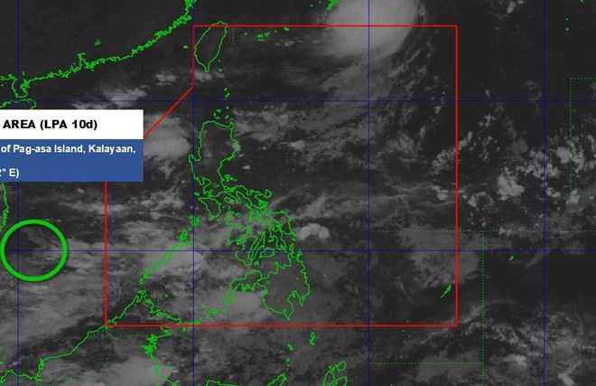
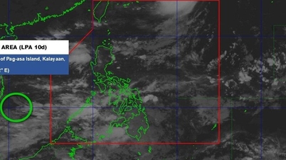
Low pressure center position in the East Sea at 2:00 a.m. on October 11. Photo: PAGASA
The latest storm/low pressure information from the Philippine Atmospheric, Geophysical and Astronomical Services Administration (PAGASA) said that at 2:00 a.m. on October 11, the center of the low pressure was at 10.9 degrees North latitude; 110.2 degrees East longitude, 445km west of Pag-asa Island, Kalayan, Palawan (Philippines), in the southern part of the East Sea, about 330km from Ke Ga Cape (formerly Binh Thuan province, now Lam Dong province).
The low pressure system is not expected to develop into a tropical depression within the next 24 hours. However, the low pressure trough is affecting the western areas of Central and Southern Luzon.
Also according to PAGASA, during the week of October 10-16, another low pressure (Low Pressure 1) is expected to form in the west of the Philippine Forecast Area (PAR), moving westward into the East Sea, towards the central waters of Vietnam. PAGASA forecasts that the low pressure is unlikely to strengthen into a storm.
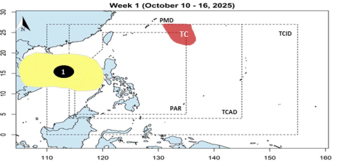
Low pressure forecast for the week of October 10-16. Photo: PAGASA
During the week of October 17-23, another low pressure (Low Pressure 2) is expected to form within the PAR. This low pressure is also unlikely to intensify into a storm.
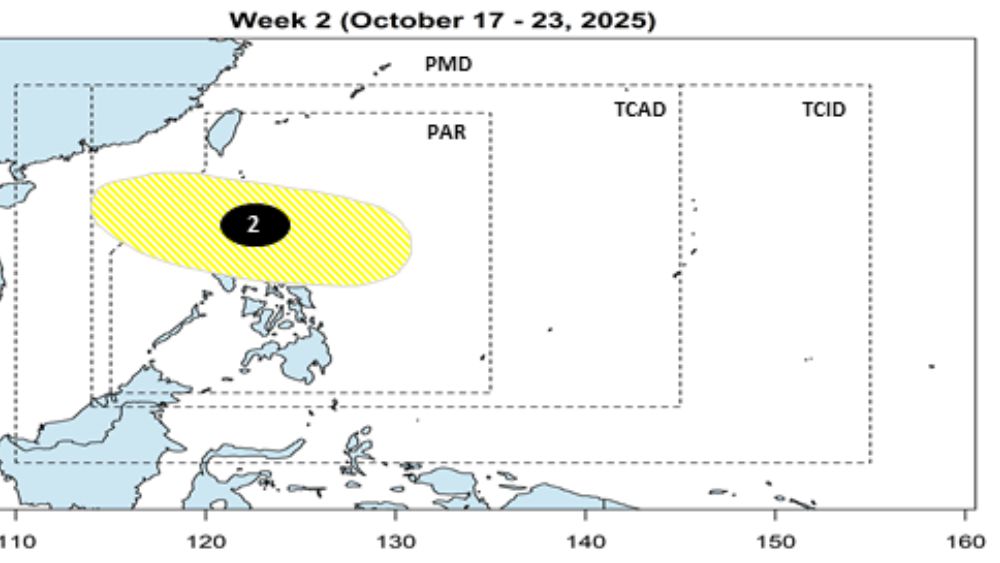
Low pressure forecast for the week of October 17-23. Photo: PAGASA
According to the weather forecast at 4am on October 11 of the Vietnam National Center for Hydro-Meteorological Forecasting, on the day and night of October 11, the Southern Gulf of Tonkin, the North - Central - South East Sea (including Hoang Sa and Truong Sa), the sea area from Quang Tri - Ca Mau, Ca Mau - An Giang and the Gulf of Thailand will have scattered showers and thunderstorms.
During thunderstorms there is a possibility of tornadoes, strong gusts of wind level 6-7, and waves over 2.0m high.
Regarding flood forecast, in the next 12 hours, flood on Cau River at Dap Cau station, on Thuong River at Phu Lang Thuong station will continue to decrease and remain above alert level 3; flood on Trung River at Huu Lung station will continue to decrease and remain below alert level 3.
In the next 12-24 hours, flood on Cau River at Dap Cau station will continue to decrease and stay below alert level 3; flood on Thuong River at Phu Lang Thuong station will continue to decrease and stay above alert level 3; flood on Trung River at Huu Lung station will continue to decrease and stay below alert level 2.
In the next 24 hours, flood on Luc Nam River (Bac Ninh) at Luc Nam station, flood on Thai Binh River (Hai Phong) at Pha Lai station will decrease and be below alert level 1.
Flooding in Thai Nguyen, Bac Ninh, Lang Son provinces and Hanoi city is likely to last for the next 1-3 days; there is a risk of riverbank and river dyke erosion and landslides on slopes in the above areas.
Regarding the cold air forecast, from the evening of October 10, a strong cold core will exist in the Siberian mainland (Russia). According to the forecast from the GFS weather model (USA), the maximum pressure of the cold core on the evening of October 10 will be up to 1060mbar, with the lowest temperature in the core dropping to minus 25 to minus 20 degrees Celsius.
It is forecasted that by around October 19-20, the first cold waves from the southeastern edge of the cold core will officially move to Vietnam, then they will likely continue to be strengthened and move deeper to the South, affecting the entire territory of the North - Central regions.
In places where the northeast monsoon blows, temperatures tend to gradually decrease. In the North, it will turn cold. In the Central region, there is a possibility of a prolonged period of heavy rain, with a risk of flooding in river basins from around October 19-20 onwards.
Laodong.vn
Source: https://laodong.vn/the-gioi/ap-thap-ap-sat-viet-nam-du-bao-lien-tiep-ap-thap-moi-khong-khi-lanh-1589662.ldo
![[Photo] General Secretary attends the parade to celebrate the 80th anniversary of the founding of the Korean Workers' Party](https://vphoto.vietnam.vn/thumb/1200x675/vietnam/resource/IMAGE/2025/10/11/1760150039564_vna-potal-tong-bi-thu-du-le-duyet-binh-ky-niem-80-nam-thanh-lap-dang-lao-dong-trieu-tien-8331994-jpg.webp)


![[Photo] Ho Chi Minh City is brilliant with flags and flowers on the eve of the 1st Party Congress, term 2025-2030](https://vphoto.vietnam.vn/thumb/1200x675/vietnam/resource/IMAGE/2025/10/10/1760102923219_ndo_br_thiet-ke-chua-co-ten-43-png.webp)
![[Photo] Opening of the World Cultural Festival in Hanoi](https://vphoto.vietnam.vn/thumb/1200x675/vietnam/resource/IMAGE/2025/10/10/1760113426728_ndo_br_lehoi-khaimac-jpg.webp)


Comment (0)