
Specifically, the flood peak at Dap Cau station is about 1.1m higher than BĐ3, and at Phu Lang Thuong station ( Bac Giang ) it exceeds the historical flood level of 1986 by about 0.18m.
Meanwhile, the water level on Trung River at Huu Lung station ( Lang Son ), Cau River at Gia Bay station (Thai Nguyen) and Thuong River at Cau Son station (Bac Giang) are showing a decreasing trend but are still above level BD3.
It is forecasted that in the next 12 - 24 hours, floods on rivers will continue to decrease, but will still remain high. The water level of Cau River at Gia Bay station is at level BĐ2, at Dap Cau station is about 0.5m above BĐ3; Thuong River at Cau Son station is 1.2m above BĐ3, Phu Lang Thuong station is 0.7m above BĐ3; Trung River at Huu Lung is still above BĐ3 by about 3m.
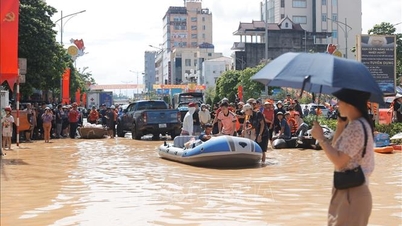
The meteorological agency warned that in the next 2-3 days, the risk of widespread flooding in the provinces of Thai Nguyen, Bac Ninh , and Lang Son is very high, especially in low-lying areas along rivers, urban areas, and residential areas along river banks in the Northern region. Along with that, landslides on river banks, river dykes, and the risk of flash floods and landslides in the northern mountainous areas are considered at a worrying level.

According to data recorded in the past 24 hours (from 4:00 on October 8 to 4:00 on October 9), the provinces of Lao Cai, Tuyen Quang, Cao Bang, Thai Nguyen and Bac Ninh have had moderate rain, heavy rain, and very heavy rain in some places. Some places with heavy rainfall include: Xuan Huong (Bac Ninh) 49.8mm, Hung Duc (Tuyen Quang) 43mm, Hoang Thu Pho (Lao Cai) 26.6mm. Soil moisture models show that many areas are nearly saturated (over 85%) or completely saturated, increasing the risk of landslides.
In the next 3-6 hours, the above area will continue to have rain with accumulated rainfall of 5-10mm, in some places over 20mm. Although the rainfall has decreased compared to previous days, because the soil and rocks have been soaked for a long time, landslides can still occur even when the rain has stopped.
The National Center for Hydro-Meteorological Forecasting warns of the risk of natural disasters due to landslides and land subsidence at level 1.
Faced with the above situation, localities in the downstream areas of Cau River and Thuong River need to proactively evacuate people from dangerous areas, strengthen inspection of dikes and reservoirs, and deploy timely response plans to ensure the safety of people and property in the coming days of floods.
Weather forecast for regions across the country:
Hanoi capital is cloudy, sunny during the day, no rain at night. Light wind. Lowest temperature 23 - 25 degrees Celsius. Highest temperature 31 - 33 degrees Celsius.
The Northwestern provinces are cloudy, sunny during the day, with showers and thunderstorms at night in some places. Light wind. Lowest temperature 22 - 25 degrees Celsius, some places below 21 degrees Celsius. Highest temperature 30 - 33 degrees Celsius, some places above 33 degrees Celsius.
The Northeast region is cloudy, sunny during the day, with scattered showers at night. Light wind. The lowest temperature is 22 - 25 degrees Celsius, in mountainous areas it is below 22 degrees Celsius. The highest temperature is 30 - 33 degrees Celsius, in some places it is above 33 degrees Celsius.
Provinces from Thanh Hoa to Hue, the North is cloudy, with showers and thunderstorms in some places; the South (Quang Tri - Hue City) is cloudy, with rain, moderate rain and scattered thunderstorms, locally heavy to very heavy rain in some places. Light wind. During thunderstorms, there is a possibility of tornadoes, lightning and strong gusts of wind. Lowest temperature 23 - 26 degrees Celsius. Highest temperature 29 - 32 degrees Celsius.
The South Central Coast region is cloudy with rain, moderate rain and scattered thunderstorms, locally heavy to very heavy rain. Northeast to east wind level 2 - 3. During thunderstorms, there is a possibility of tornadoes, lightning and strong gusts. Lowest temperature 23 - 26 degrees Celsius. Highest temperature 28 - 31 degrees Celsius.
The Central Highlands is cloudy with scattered showers and thunderstorms, with scattered showers and thunderstorms in the afternoon and evening, and locally heavy rain. Light winds. Thunderstorms may include tornadoes, lightning, and strong gusts of wind. Lowest temperature 19 - 22 degrees Celsius. Highest temperature 28 - 31 degrees Celsius.
The South is cloudy with rain, moderate rain and scattered thunderstorms, locally heavy to very heavy rain (rain is concentrated in the afternoon and night). West to southwest wind level 2 - 3. During thunderstorms, there is a possibility of tornadoes, lightning and strong gusts of wind. Lowest temperature 23 - 26 degrees Celsius. Highest temperature 29 - 32 degrees Celsius.
Ho Chi Minh City is cloudy with rain, moderate rain and scattered thunderstorms, locally heavy to very heavy rain (rain is concentrated in the afternoon and night). West to southwest wind level 2 - 3. During thunderstorms, there is a possibility of tornadoes, lightning and strong gusts of wind. Lowest temperature 23 - 25 degrees Celsius. Highest temperature 30 - 32 degrees Celsius.
Source: https://baotintuc.vn/xa-hoi/thoi-weather-ngay-910-lu-dac-biet-lon-tren-song-cau-song-thuong-canh-bao-ngap-lut-dien-rong-o-bac-bo-20251009051904012.htm


![[Photo] General Secretary To Lam visits Kieng Sang Kindergarten and the classroom named after Uncle Ho](https://vphoto.vietnam.vn/thumb/1200x675/vietnam/resource/IMAGE/2025/10/09/1760023999336_vna-potal-tong-bi-thu-to-lam-tham-truong-mau-giao-kieng-sang-va-lop-hoc-mang-ten-bac-ho-8328675-277-jpg.webp)
![[Photo] Prime Minister Pham Minh Chinh chairs a meeting of the Government Standing Committee on overcoming the consequences of natural disasters after storm No. 11](https://vphoto.vietnam.vn/thumb/1200x675/vietnam/resource/IMAGE/2025/10/09/1759997894015_dsc-0591-jpg.webp)

![[Photo] President Luong Cuong attends the 80th Anniversary of the Traditional Day of Vietnamese Lawyers](https://vphoto.vietnam.vn/thumb/1200x675/vietnam/resource/IMAGE/2025/10/09/1760026998213_ndo_br_1-jpg.webp)


Comment (0)