
 |
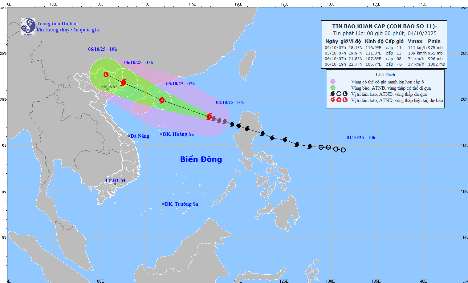
| Forecast map of storm No. 11's trajectory and intensity issued at 08:00 on October 4, 2025 (Source: National Center for Hydro-Meteorological Forecasting). |
Storm forecast (in the next 24 to 60 hours):
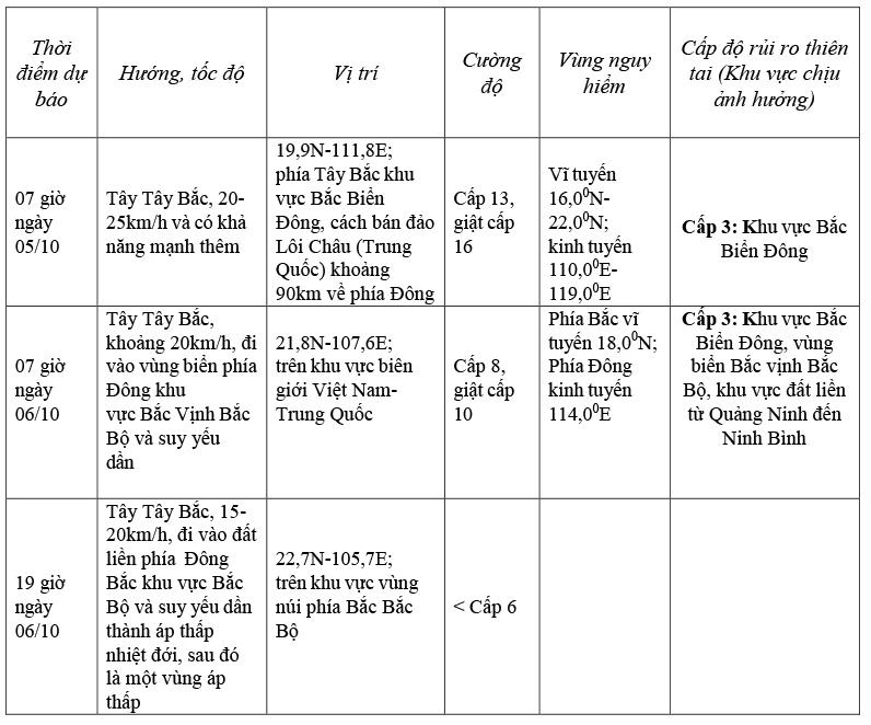 |
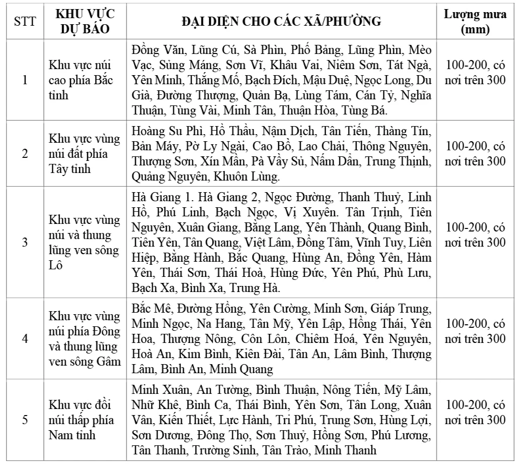
Forecast of storm impact on Tuyen Quang province:
Heavy rain: On the night of October 5, there will be scattered showers and thunderstorms in some areas; from the morning of October 6 to the end of the night of October 7, there will be heavy to very heavy rain and scattered thunderstorms in Tuyen Quang province. Rainfall is generally from 100-200mm/period, in some places over 300mm/period. Warning of heavy rain (>100mm/3 hours). The circulation of storm No. 11 is relatively wide, so it is necessary to be on guard against the possibility of tornadoes, lightning and strong gusts of wind both before and during the storm.
Detailed heavy rain forecast to commune/ward level:
 |
At sea:
- In the North East Sea, there are strong winds of level 8-10, near the storm center level 11-13, gusts of level 16, waves 4.0-6.0m high, near the storm center 6.0-8.0m, very rough seas (extremely destructive, extremely strong waves. Sinking large tonnage ships).
- From the afternoon of October 5, the sea area east of the Northern Gulf of Tonkin (including Bach Long Vi special zone) has winds gradually increasing to level 6-7, then increasing to level 8-9. From the evening of October 5, the sea area north of the Gulf of Tonkin (including Bach Long Vi special zone, Van Don, Co To, Cat Hai and Hon Dau island) has winds gradually increasing to level 8-9, waves 2.0-4.0m high, near the center of the storm
Passing level 10-11, gusting level 14, waves 3.0-5.0m high, rough sea (rough sea, very dangerous for ships).
Storm surge and coastal flood warnings:
Coastal areas and islands in Quang Ninh - Hai Phong provinces have storm surges of 0.4-0.6m. Beware of flooding in low-lying coastal areas and river mouths due to surges and big waves from the afternoon and evening of October 5.
Warning: The weather at sea and in coastal areas during the storm is extremely dangerous and unsafe for any vehicle or structure operating in the danger zone such as: cruise ships, passenger ships, transport ships, cages, rafts, aquaculture areas, dykes, embankments, coastal routes. Vehicles are at high risk of capsize, destruction, and flooding due to strong winds, big waves, and rising sea levels.
On land:
From the night of October 5, on the mainland from Quang Ninh to Ninh Binh, the wind will gradually increase to level 6-7, near the storm center, level 8-9 (The wind will break tree branches, blow off roofs, causing damage to houses. It is impossible to go against the wind.). The deep inland area of the Northeast will have strong winds of level 5, in some places level 6, gusting to level 7-8.
Source: https://baotuyenquang.com.vn/xa-hoi/202510/tin-bao-khan-cap-con-bao-so-11-1d644ab/


![[Photo] General Secretary To Lam attends the 8th Congress of the Central Public Security Party Committee](https://vphoto.vietnam.vn/thumb/1200x675/vietnam/resource/IMAGE/2025/10/4/79fadf490f674dc483794f2d955f6045)


![[Infographic] Notable numbers after 3 months of "reorganizing the country"](https://vphoto.vietnam.vn/thumb/1200x675/vietnam/resource/IMAGE/2025/10/4/ce8bb72c722348e09e942d04f0dd9729)


![[Photo] Students of Binh Minh Primary School enjoy the full moon festival, receiving the joys of childhood](https://vphoto.vietnam.vn/thumb/1200x675/vietnam/resource/IMAGE/2025/10/3/8cf8abef22fe4471be400a818912cb85)
![[Photo] Prime Minister Pham Minh Chinh chairs meeting to deploy overcoming consequences of storm No. 10](https://vphoto.vietnam.vn/thumb/1200x675/vietnam/resource/IMAGE/2025/10/3/544f420dcc844463898fcbef46247d16)


Comment (0)