
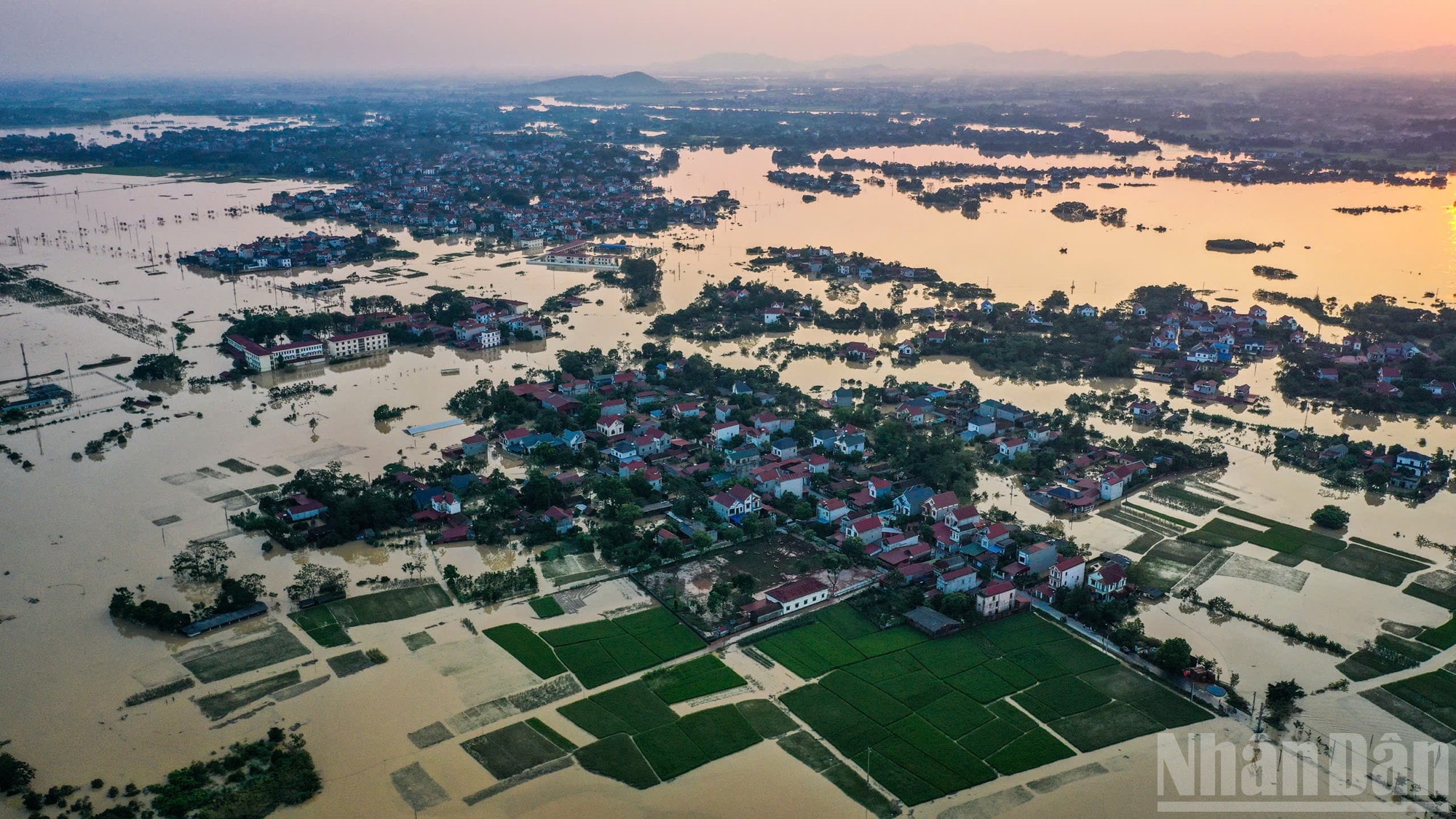
Many rivers in the North continue to record water levels exceeding alert level 3. Floods on Cau, Thuong and Trung rivers are developing complicatedly, posing a risk of widespread flooding and landslides in Bac Ninh , Lang Son and Thai Nguyen provinces.
At 7:00 p.m. on October 9, the water level at Dap Cau station (Cau River) reached 7.49m, about 1.19m higher than alert level 3. On Thuong River, the water level at Cau Son station was recorded at 18.02m, more than 2m higher than alert level 3, while Phu Lang Thuong station was at 7.56m, 1.26m higher than alert level 3 and 0.03m higher than the historical flood peak in 1986.
At Trung River, Huu Lung station recorded a water level of 22.57m, also exceeding the historical level of 1986 by 0.03m.
24-hour forecast: Floods peak and recede slowly
According to the forecast of the hydrometeorological agency, in the next 12 hours, Cau River at Dap Cau station is likely to peak, exceeding alert level 3 by about 1.3m. Floods on Thuong and Trung rivers will continue to decrease but remain above alert level 3.
In the next 12 to 24 hours, water levels on rivers are forecast to recede slowly, especially at Dap Cau, Cau Son and Phu Lang Thuong. However, floods remain high, which may affect the dike system and riverside residential areas.
In addition, in the next 24 hours, water levels on the Luc Nam River (Bac Ninh) and the Thai Binh River (Hai Phong) are expected to fluctuate around alert level 1, indicating a risk of widespread flooding if heavy rain continues.
Risk of flooding and landslides in many northern provinces
According to warnings, widespread flooding is likely to continue in the next 2-3 days in Thai Nguyen, Bac Ninh and Lang Son provinces, especially in low-lying riverside areas and low-lying urban areas.
Mountainous areas in the North need to be especially vigilant against riverbank landslides, dike landslides and landslides on steep slopes, with high risks due to the soil being saturated with water after many days of heavy rain.
People can monitor real-time flash flood and landslide warning information on luquetsatlo.nchmf.gov.vn to promptly grasp dangerous developments and have appropriate response measures.
Disaster risk level: Level 3
Floods on the Cau and Thuong river systems are seriously affecting waterway transport, aquaculture, agricultural production and the lives of people in downstream areas. Many riverside areas have been isolated, making transportation difficult.
Authorities recommend that local authorities proactively evacuate people from dangerous areas, check dike systems and reservoirs, and prepare response plans in case of unusual flood surges.
Forecast information will be updated regularly, especially if there are changes in discharge flows from upstream hydropower reservoirs and lakes.
Source: https://baonghean.vn/tin-lu-bac-ninh-lu-song-cau-song-thuong-co-the-cham-dinh-lu-lich-su-vao-sang-10-10-10307959.html

![[Photo] "Exposing letters" in the flood center of Lang Son](https://vphoto.vietnam.vn/thumb/1200x675/vietnam/resource/IMAGE/2025/10/10/1760080117518_ndo_br_z7101324112737-07cd4d1c01801a8ccf4ae0cbaf31c4a3-507-jpg.webp)
![[Photo] Standing member of the Secretariat Tran Cam Tu works with the Standing Committee of the Party Committee of the Ministry of Health](https://vphoto.vietnam.vn/thumb/1200x675/vietnam/resource/IMAGE/2025/10/10/1760079818773_image-4-6972-jpg.webp)

![[Photo] Prime Minister Pham Minh Chinh attends the Patriotic Emulation Congress of Hanoi city](https://vphoto.vietnam.vn/thumb/1200x675/vietnam/resource/IMAGE/2025/10/10/1760078918257_dsc-2008-jpg.webp)


![[Photo] President Luong Cuong presents decisions on conferring titles and appointing Vietnamese Ambassadors](https://vphoto.vietnam.vn/thumb/402x226/vietnam/resource/IMAGE/2025/10/10/1760082105623_image-1.jpeg)


Comment (0)