
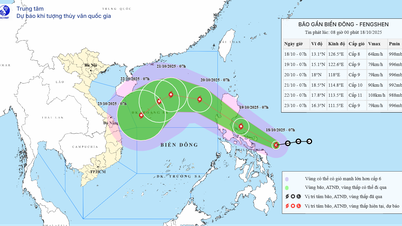
Many localized areas have heavy rain
The National Center for Hydro-Meteorological Forecasting forecasts that during the day and night of October 17, the area from Nghe An to Ha Tinh, from Gia Lai to Lam Dong and the South will have scattered showers and thunderstorms with rainfall of 10-30 mm, locally heavy rain over 60 mm (rain will mainly concentrate in the afternoon and evening).
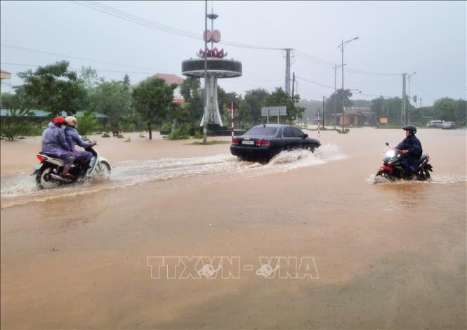
Warning, on the day and night of October 19, the area from Ha Tinh to Quang Ngai will have moderate rain, heavy rain and thunderstorms with common rainfall of 30-60 mm, locally very heavy rain over 100 mm.
The heavy rains in the Central region are likely to continue. The risk of natural disasters due to heavy rain, tornadoes, lightning, and hail is level 1.
"Heavy rain is likely to cause flooding in low-lying areas, urban and industrial areas; flash floods on small rivers and streams, landslides on steep slopes (real-time warning information on areas at risk of flash floods and landslides is provided online on the website of the Department of Hydrometeorology at: https://luquetsatlo.nchmf.gov.vn and in a separate bulletin warning of flash floods and landslides). During thunderstorms, there is a possibility of tornadoes, lightning, hail and strong gusts of wind," noted Deputy Head of the Weather Forecast Department Vu Anh Tuan.
Flood warning on rivers from Quang Tri to Hue and the Mekong River
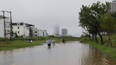
The National Center for Hydro-Meteorological Forecasting said that from October 17 to October 19, 2025, there is a possibility of a flood occurring on rivers from Quang Tri to Hue city. During this flood, the peak water level on the rivers is likely to rise to alert level 1 to alert level 2. There is a high risk of flooding in low-lying areas along rivers, flash floods and landslides on steep slopes in the provinces from Quang Tri to Hue city (real-time warning information on areas at risk of flash floods and landslides is provided online on the website of the Department of Hydro-Meteorological Forecasting at: https://luquetsatlo.nchmf.gov.vn and in a separate bulletin warning of flash floods and landslides). Level 1 flood disaster risk.
Regarding the flood situation on the Mekong River, the water level in the upstream of the Mekong River will change slowly and be affected by the tide. By October 21, the highest water level on the Tien River at Tan Chau station was down to 3.73 m, 0.23 m above alert level 1; on the Hau River at Chau Doc station was down to 3.38 m, 0.12 m below alert level 2; at the downstream stations of the Mekong River, it fluctuated between alert level 1 and alert level 2.
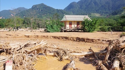
Risk of flooding in low-lying areas, riverside areas, and areas outside the dyke in An Giang province and low-lying areas, riverside areas in Dong Thap, Can Tho, and Vinh Long provinces. Beware of landslides and weak dykes in flooded areas. Flood risk level 1.
Floods on rivers and streams can cause flooding in low-lying areas along rivers, affecting activities such as waterway transport, aquaculture, agricultural production, people's lives and socio-economic activities.
Potential for tornadoes and strong gusts of wind in many coastal areas
According to the National Center for Hydro-Meteorological Forecasting, on the night of October 17, the northeastern sea area of the North East Sea will have strong winds of level 6, gusts of level 7-8, rough seas, and waves 2.5-3.5 m high.
In addition, on the day and night of October 17, the sea area from Quang Tri to Ca Mau, from Ca Mau to An Giang, the Gulf of Thailand, the central and southern East Sea (including Truong Sa special zone) will have scattered showers and thunderstorms, with the possibility of tornadoes, strong gusts of wind of level 6-7 and waves over 2 meters high.
Warning, on the day and night of October 18, the sea area in the East of the North East Sea will have strong Northeast wind level 6, gusting to level 7-8, rough sea; waves from 2.5-3.5 m high. The risk level of natural disasters in the sea area in the Northeast of the North East Sea is level 2.
All vessels operating in the above areas are at high risk of being affected by strong winds and large waves.
According to the guidance of the Ministry of Agriculture and Environment, affected coastal provinces and cities must closely monitor warning bulletins, forecasts and developments of strong winds at sea; notify captains and owners of vehicles and vessels operating at sea to proactively prevent and have appropriate production plans, ensuring safety of people and property; maintain communication to promptly handle bad situations that may occur.
Source: https://baotintuc.vn/xa-hoi/tu-quang-tri-den-quang-ngaicuc-bo-co-noi-mua-rat-to-tren-300-mm-20251017112306271.htm


![[Photo] Closing ceremony of the 18th Congress of Hanoi Party Committee](https://vphoto.vietnam.vn/thumb/1200x675/vietnam/resource/IMAGE/2025/10/17/1760704850107_ndo_br_1-jpg.webp)


![[Photo] Nhan Dan Newspaper launches “Fatherland in the Heart: The Concert Film”](https://vphoto.vietnam.vn/thumb/1200x675/vietnam/resource/IMAGE/2025/10/16/1760622132545_thiet-ke-chua-co-ten-36-png.webp)


![[Infographic] Organizing to collect public opinions on draft documents to be submitted to the 14th National Party Congress](https://vphoto.vietnam.vn/thumb/402x226/vietnam/resource/IMAGE/2025/10/18/1760774470262_anh-bia-copy.jpeg)


Comment (0)