
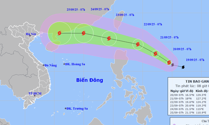
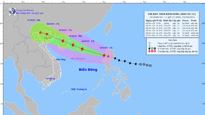
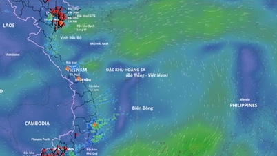
Forecast of the location and direction of storm Ragasa at 1:00 p.m. on September 20 - Photo: NCHMF
According to the National Center for Hydro-Meteorological Forecasting at 1:00 p.m. on September 20, the center of storm Ragasa was about 730km east of Luzon Island (Philippines).
The strongest wind near the storm center is level 12 (118-133km/h), gusting to level 15 - up 3 levels compared to 7pm last night and up 1 level compared to 7am this morning.
Mr. Nguyen Van Huong, Head of Weather Forecasting Department, National Center for Hydro-Meteorological Forecasting, said that the current temperature of the Pacific Ocean is higher than 30 degrees Celsius, creating favorable conditions for storm Ragasa to rapidly increase in strength, and may reach super typhoon level in the coming days.
According to Mr. Huong, around September 23, storm Ragasa is likely to enter the East Sea and become storm number 9 this year.
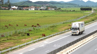
The storm may then affect mainland Vietnam between September 24 and 26 and cause strong winds and heavy rain in the Northern and Central regions.
Mr. Huong also noted that after entering the East Sea, the forecast of the movement of storm Ragasa is still very unpredictable due to the influence of many factors, so people need to pay attention to updated forecasts to proactively respond.
The National Center for Hydro-Meteorological Forecasting predicts that in the next 24 hours, storm Ragasa will move west-northwest at a speed of 10-15km/h and is likely to strengthen.
At 1:00 p.m. tomorrow, the storm center will be about 490 km east-northeast of Luzon Island, with storm intensity at level 13-14 (134-166 km/h), gusting to level 16.
During the next 24 to 48 hours, the storm will move west-northwest at a speed of 15-20km/h and continue to strengthen.
At 1 p.m. on September 22, the storm center was about 220 kilometers north-northeast of Luzon Island (Philippines). The strongest winds near the storm center were at level 15-16 (super typhoon, 167-201 km/h), gusting to level 17.
In the next 48 to 72 hours, the storm will move west-northwest at a speed of 20-25 km/h, entering the East Sea, with little chance of changing its intensity. By 1:00 p.m. on September 23, the center of Ragasa storm was in the northeastern sea of the northern East Sea, with the storm's intensity remaining at level 15-16, gusting to level 17.
From the next 72 to 120 hours, the storm will move mainly westward, about 20km per hour, and its intensity will likely gradually weaken.
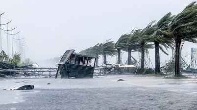
From the afternoon of September 22, the sea area east of the northern East Sea has strong winds of level 6-7, then increasing to level 8-9, gusting to level 11.
From the night of September 22, the storm wind increased to level 10-13, near the storm center level 14-16, gusting over level 17, waves 4-8m high, near the storm center over 10m, rough seas.
Vessels operating in the above mentioned dangerous areas are susceptible to the impact of storms, whirlwinds, strong winds and large waves.
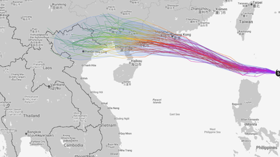
Japan, Hong Kong forecast that typhoon Ragasa may enter the Gulf of Tonkin
According to the Japan Meteorological Agency (JMA), at 3:00 p.m. on September 20 (Japan time), the storm was at level 12 (35 m/s), gusting at level 15 (50 m/s). JMA assessed that the maximum intensity of storm Rasaga reached the end of level 15 (50 m/s), gusting at over level 17 (70 m/s).
After entering the East Sea, storm Rasaga headed towards the coastal area of Guangdong province (China), then the storm moved along the coast, towards the north of Leizhou peninsula and entered the Gulf of Tonkin with an intensity of about level 12 (35m/s).
Meanwhile, Hong Kong's typhoon forecasting agency said that storm Ragasa will strengthen into a super typhoon with maximum winds of 205km/h (level 17).
Hong Kong also forecasts that Ragasa will enter the Gulf of Tonkin with strong winds of level 13 (140km/h), but before that, the storm will make landfall along the coast of Guangdong province and then north of the Leizhou peninsula.
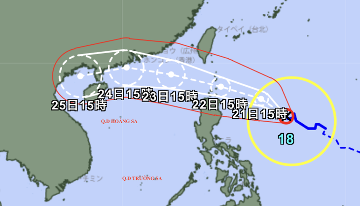
Forecast of the location and direction of Japan's storm Ragasa - Photo: JMA
Source: https://tuoitre.vn/bao-ragasa-manh-len-cap-12-giat-cap-15-du-bao-vao-vinh-bac-bo-20250920143931488.htm

![[Photo] Opening of the World Cultural Festival in Hanoi](https://vphoto.vietnam.vn/thumb/1200x675/vietnam/resource/IMAGE/2025/10/10/1760113426728_ndo_br_lehoi-khaimac-jpg.webp)


![[Photo] Discover unique experiences at the first World Cultural Festival](https://vphoto.vietnam.vn/thumb/1200x675/vietnam/resource/IMAGE/2025/10/11/1760198064937_le-hoi-van-hoa-4199-3623-jpg.webp)
![[Photo] General Secretary attends the parade to celebrate the 80th anniversary of the founding of the Korean Workers' Party](https://vphoto.vietnam.vn/thumb/1200x675/vietnam/resource/IMAGE/2025/10/11/1760150039564_vna-potal-tong-bi-thu-du-le-duyet-binh-ky-niem-80-nam-thanh-lap-dang-lao-dong-trieu-tien-8331994-jpg.webp)


![[Photo] Ho Chi Minh City is brilliant with flags and flowers on the eve of the 1st Party Congress, term 2025-2030](https://vphoto.vietnam.vn/thumb/1200x675/vietnam/resource/IMAGE/2025/10/10/1760102923219_ndo_br_thiet-ke-chua-co-ten-43-png.webp)


Comment (0)