
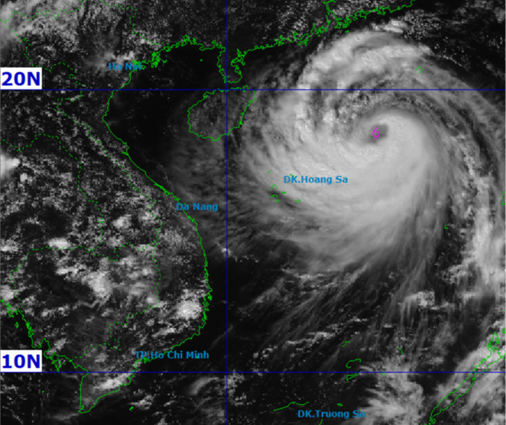
Satellite image of storm Matmo at 1 p.m. this afternoon - Photo: NCHMF
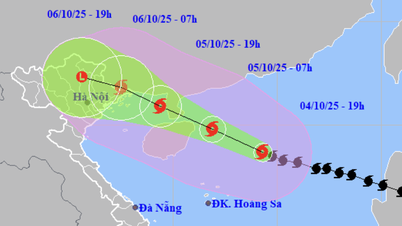
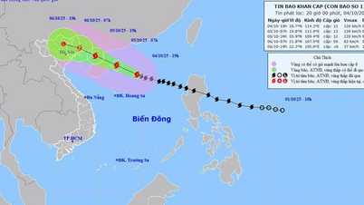
On the afternoon of October 4, Mr. Nguyen Van Huong, Head of the Weather Forecast Department, National Center for Hydro-Meteorological Forecasting, said that at 1:00 p.m. this afternoon, the center of storm Matmo was about 350km east-northeast of Hoang Sa special zone.
The strongest wind near the storm center is level 11-12 (103-133km/h), gusting to level 15.
According to Mr. Huong, the storm is forecast to move quickly in the west-northwest direction at a speed of about 25km/h in the next 24 hours and is likely to strengthen.
"When entering the East Sea, the storm tends to strengthen because the sea surface temperature is at 28-29 degrees Celsius, the wind shear in the East Sea is small, this creates moisture that accumulates and develops according to the structure of the storm. It is forecasted that in the next 24 hours, the storm's intensity may strengthen to level 13 (134-149 km/h), gusting to level 16.
However, when passing through the Loi Chau island area and entering the Gulf of Tonkin, due to friction with the ground and increased wind shear, the storm's intensity tends to decrease," said Mr. Huong.
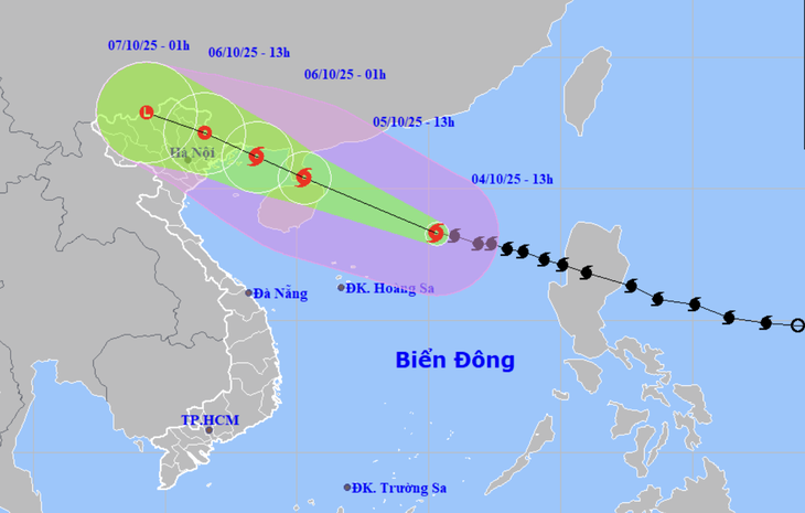
Forecast of location and direction of storm Matmo at 1:00 p.m. October 4 - Photo: NCHMF
According to Mr. Huong, by noon today, the center has determined that the storm is likely to move more northward, so it is likely to make landfall between Quang Ninh (Vietnam) and Guangxi (China). Therefore, in the Quang Ninh area, there is a possibility of strong winds of level 8-9, other areas such as Lang Son and old Bac Giang are likely to have strong winds of level 6-7.
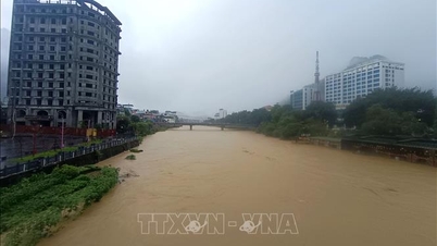
For the Hanoi area, there is little chance of being directly affected by storm winds. It is forecasted that from early morning of October 6 to the end of October 7, there will be moderate to heavy rain, with average rainfall of 70-120mm, and in some places over 150mm.
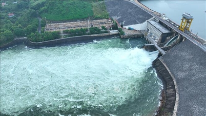
Coastal areas and islands in Quang Ninh - Hai Phong provinces are likely to experience storm surges of 0.4-0.6m. Flooding should be prevented in low-lying coastal areas and river mouths due to surges combined with large waves from the afternoon and evening of October 5-10.
Also due to the influence of storm Matmo, from the night of October 5 to October 7, there is a possibility of widespread heavy rain in the North, with the focus on the mountainous and midland areas of the North, with total rainfall forecast to be 150-250mm, with some places over 400mm. Meanwhile, the Northern Delta and Thanh Hoa regions will have rain of 70-120mm, with some places over 200mm.
If the storm continues to move further north, the impact of wind and rain in the delta region and Hanoi will decrease further.
"Storm Matmo has a wide circulation, so it is possible that while the storm's eye is still at sea, thunderstorms may occur before and during the storm, focusing on the Gulf of Tonkin and the Northern region," Mr. Huong noted.
Source: https://tuoitre.vn/bao-matmo-manh-len-dau-cap-12-giat-cap-15-kha-nang-con-manh-them-20251004135825763.htm

![[Photo] General Secretary To Lam attends the 8th Congress of the Central Public Security Party Committee](https://vphoto.vietnam.vn/thumb/1200x675/vietnam/resource/IMAGE/2025/10/4/79fadf490f674dc483794f2d955f6045)
![[Photo] Solemn opening of the 8th Congress of the Central Public Security Party Committee, term 2025-2030](https://vphoto.vietnam.vn/thumb/1200x675/vietnam/resource/IMAGE/2025/10/4/f3b00fb779f44979809441a4dac5c7df)
![[Photo] Bustling Mid-Autumn Festival at the Museum of Ethnology](https://vphoto.vietnam.vn/thumb/1200x675/vietnam/resource/IMAGE/2025/10/4/da8d5927734d4ca58e3eced14bc435a3)


![[VIDEO] Summary of Petrovietnam's 50th Anniversary Ceremony](https://vphoto.vietnam.vn/thumb/402x226/vietnam/resource/IMAGE/2025/10/4/abe133bdb8114793a16d4fe3e5bd0f12)

![[VIDEO] GENERAL SECRETARY TO LAM AWARDS PETROVIETNAM 8 GOLDEN WORDS: "PIONEER - EXCELLENT - SUSTAINABLE - GLOBAL"](https://vphoto.vietnam.vn/thumb/402x226/vietnam/resource/IMAGE/2025/7/23/c2fdb48863e846cfa9fb8e6ea9cf44e7)


Comment (0)