
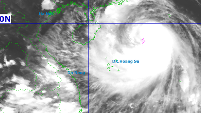
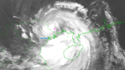
At 4:00 a.m., the center of the storm was at about 22.0 degrees North latitude; 107.6 degrees East longitude, in the southern area of Guangxi province (China). The strongest wind near the center of the storm was level 8 (62-74 km/h), gusting to level 10. Moving in the West Northwest direction, speed about 20 km/h.
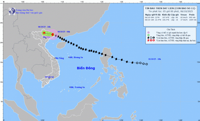
By 4:00 p.m. this afternoon, storm No. 11 will be in the mountainous region of the North and weaken into a low pressure area.
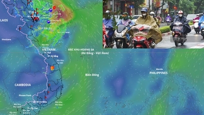
Due to the storm's influence, from early this morning until the end of the night of October 7, the mountainous and midland areas of the North will have heavy rain, with rainfall ranging from 100-200mm, and locally very heavy rain over 300mm. Warning of the risk of heavy rain (>150mm/3 hours); the Northern Delta and Thanh Hoa regions will have moderate to heavy rain with rainfall ranging from 50-150mm, and locally very heavy rain over 200mm.
Hanoi area is less likely to be affected by storms but there will still be moderate to heavy rain with common rainfall of 50-100mm, locally over 150mm. Beware of thunderstorms, whirlwinds and strong gusts of wind.
Weather nationwide on Monday (October 6), Hanoi capital is cloudy, with moderate rain, heavy rain and thunderstorms, locally very heavy rain. Northwest to north wind level 3-4; then change to southeast wind level 2-3. During thunderstorms there is a possibility of tornadoes, lightning and strong gusts. Lowest temperature 24-26 degrees. Highest temperature 28-30 degrees.

The Northwest region is cloudy with scattered showers and thunderstorms, some places have heavy rain; in the afternoon and at night there will be moderate rain, heavy rain, some places have very heavy rain. Light wind. During thunderstorms there is a possibility of tornadoes, lightning and strong gusts of wind. Lowest temperature 21-24 degrees, some places below 21 degrees. Highest temperature 28-31 degrees.
The Northeast region is cloudy with heavy rain, locally very heavy rain and thunderstorms; the Delta and Thanh Hoa regions have moderate rain, heavy rain and thunderstorms, locally very heavy rain. The wind is from the northwest to the north; then changes to the southeast at level 3-4; in the morning, Quang Ninh and Lang Son have strong winds at level 6, gusting at level 7-8. There is a possibility of tornadoes, lightning and strong gusts of wind during thunderstorms. The lowest temperature is 22-25 degrees. The highest temperature is 27-30 degrees, some places are over 30 degrees.
From Thanh Hoa to Hue, the North is cloudy with scattered showers and thunderstorms; the South is cloudy with scattered showers and thunderstorms. Southwest wind level 2-3. During thunderstorms, there is a possibility of tornadoes, lightning and strong gusts of wind. Lowest temperature 24-27 degrees. Highest temperature 30-33 degrees.
The South Central Coast is cloudy with scattered showers and thunderstorms. Southwesterly winds at level 2-3. There is a possibility of tornadoes, lightning, and strong gusts of wind during thunderstorms. Lowest temperature 24-27 degrees Celsius. Highest temperature 31-34 degrees Celsius.
Central Highlands: Cloudy, sunny during the day, scattered showers and thunderstorms in the evening and at night. Southwest wind level 2-3. Lowest temperature 20-23 degrees, below 20 degrees in some places. Highest temperature 28-31 degrees.
The South is cloudy, sunny during the day, with showers and thunderstorms in some places in the evening and at night. Southwest wind level 2-3. Lowest temperature 24-27 degrees. Highest temperature 31-34 degrees.
Ho Chi Minh City is cloudy, sunny during the day, with showers and thunderstorms in some places in the evening and at night. Southwest wind level 2-3. Lowest temperature 24-26 degrees. Highest temperature 32-34 degrees.
Source: https://cand.com.vn/doi-song/bao-so-11-do-bo-dat-lien-mien-bac-mua-to-gio-lon-i783657/
![[Photo] Opening of the 13th Conference of the 13th Party Central Committee](https://vphoto.vietnam.vn/thumb/1200x675/vietnam/resource/IMAGE/2025/10/6/d4b269e6c4b64696af775925cb608560)

![[Photo] Prime Minister Pham Minh Chinh chairs the Government's online conference with localities](https://vphoto.vietnam.vn/thumb/1200x675/vietnam/resource/IMAGE/2025/10/5/264793cfb4404c63a701d235ff43e1bd)

![[Photo] Prime Minister Pham Minh Chinh launched a peak emulation campaign to achieve achievements in celebration of the 14th National Party Congress](https://vphoto.vietnam.vn/thumb/1200x675/vietnam/resource/IMAGE/2025/10/5/8869ec5cdbc740f58fbf2ae73f065076)


Comment (0)