
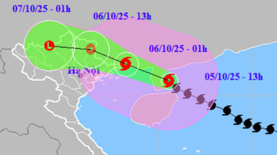
At 12 noon today, the storm center approached China's Leizhou peninsula, about 310km east-southeast of Mong Cai ( Quang Ninh ) with a level 12-13 intensity, gusting to level 16.
It is forecasted that late this afternoon, the storm will pass the Loi Chau peninsula to enter the Gulf of Tonkin with an intensity of level 12, gusting to level 15. At 10 pm tonight, while in the sea of Quang Ninh province, the storm will still maintain an intensity of level 11 - 12, gusting to level 15.
It is forecasted that early tomorrow morning, the eye of the storm will begin to make landfall in the Vietnam - China border area with an intensity of about level 9 - 10, gusting to level 12 - 13. Tomorrow morning, the storm will move deep into our mainland and weaken into a tropical depression.
At 10:00 a.m. on October 6, the center of the tropical depression was over the mainland of Lang Son province (Vietnam) and Guangxi (China) with an intensity of level 6 - 7, gusting to level 9. In the afternoon of October 6, the tropical depression moved deep into the mountainous region of Northern Vietnam and weakened into a low pressure area. At 10:00 p.m. on October 6, the center of the low pressure area was over the Tuyen Quang - Lao Cai area with an intensity below level 6.
.")
Details of strong winds and heavy rain caused by storm Matmo
According to Mr. Mai Van Khiem - Director of the National Center for Hydro-Meteorological Forecasting, due to the influence of storm Matmo, it is forecasted that from the night of October 5 to noon on October 6, on the mainland in coastal areas from Quang Ninh to Hung Yen and Lang Son province, winds will gradually increase to level 6 - 7, near the storm center, level 8 - 10, gusting to level 11 - 12. Inland areas in the Northeast, there will be strong winds of level 4 - 5, in some places level 6, gusting to level 7 - 8.
In particular, communes/wards in the northeastern area of Quang Ninh province are likely to have strong winds of level 9-10, gusts of level 12-13, while the remaining communes/wards of Quang Ninh province and coastal areas of Hai Phong are likely to have strong winds of level 8-9, gusts of level 10-11.
Coastal communes/wards of Hung Yen province and northern border communes of Lang Son province are likely to have strong winds of level 6 - 8, gusts of level 9 - 10. The northeastern area of Bac Ninh province (old Bac Giang) is likely to have strong winds of level 6 - 7, gusts of level 8 - 9.
From the afternoon of October 5, the Northern Gulf of Tonkin area (including Bach Long Vy, Van Don, Co To, Cat Hai and Hon Dau islands) will have winds gradually increasing to level 6 - 7, then increasing to level 8 - 9, near the storm center will be level 10 - 12, gusting to level 15, waves 2 - 4m high, near the storm center 3-5m, rough seas.
In addition, coastal areas and islands in Quang Ninh-Hai Phong provinces will have storm surges of 0.4-0.6m from this afternoon and evening. Beware of flooding in low-lying coastal and estuary areas.
The meteorological agency maintains the warning of heavy rain. Specifically, from the night of October 5 to the end of the night of October 7, the mountainous and midland areas of the North will have heavy rain, with rainfall ranging from 150-250mm, and in some places, very heavy rain of over 400mm.
The Northern Delta region and Thanh Hoa have moderate to heavy rain with common rainfall of 70 - 150mm, locally very heavy rain over 200mm.
Hanoi from early morning October 6 to the end of October 7 will also have moderate to heavy rain, with common rainfall of 70 - 120mm, in some places over 150mm. During thunderstorms, be on guard against tornadoes and strong gusts of wind.
Due to heavy rain, from tonight (October 5) to October 9, there is a possibility of a flood on rivers in the Northern region and Thanh Hoa, with flood levels rising 4-8m in the upper reaches of rivers and 2-5m in the lower reaches of rivers.
During this flood, the flood peak on rivers in Quang Ninh, Lang Son, Cao Bang provinces; the flood peak on Thao River, Chay River (Lao Cai), Hoang Long River (Ninh Binh), Lo River (Tuyen Quang), Thai Binh River system (Thai Nguyen, Bac Ninh, Hai Phong) and small rivers reached level BĐ2 - BĐ3 and above BĐ3, the flood peak at Hoa Binh Lake, Buoi River, Ma River, Chu River (Thanh Hoa), the downstream of Red River reached level BĐ1 - BĐ2, in some places above BĐ2.
Due to heavy rains and rising floods in the area that was recently hit hard by Typhoon Bualoi, the meteorological agency warned of a very high risk of flash floods and landslides in the mountainous areas of the North after the storm. Rising floods on rivers in the North and Thanh Hoa could also cause widespread flooding.
Source: https://baolaocai.vn/bao-so-11-manh-len-nang-muc-canh-bao-gio-tren-dat-lien-post883733.html
![[Photo] Prime Minister Pham Minh Chinh chairs the Government's online conference with localities](https://vphoto.vietnam.vn/thumb/1200x675/vietnam/resource/IMAGE/2025/10/5/264793cfb4404c63a701d235ff43e1bd)
![[Photo] Prime Minister Pham Minh Chinh launched a peak emulation campaign to achieve achievements in celebration of the 14th National Party Congress](https://vphoto.vietnam.vn/thumb/1200x675/vietnam/resource/IMAGE/2025/10/5/8869ec5cdbc740f58fbf2ae73f065076)


![[VIDEO] Summary of Petrovietnam's 50th Anniversary Ceremony](https://vphoto.vietnam.vn/thumb/402x226/vietnam/resource/IMAGE/2025/10/4/abe133bdb8114793a16d4fe3e5bd0f12)

![[VIDEO] GENERAL SECRETARY TO LAM AWARDS PETROVIETNAM 8 GOLDEN WORDS: "PIONEER - EXCELLENT - SUSTAINABLE - GLOBAL"](https://vphoto.vietnam.vn/thumb/402x226/vietnam/resource/IMAGE/2025/7/23/c2fdb48863e846cfa9fb8e6ea9cf44e7)


Comment (0)