
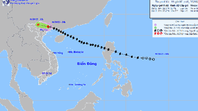
The National Center for Hydro-Meteorological Forecasting said that after reaching its strongest intensity in the East Sea, storm Matmo (storm number 11) has begun to weaken.

Typhoon Matmo begins to weaken as it enters Leizhou Peninsula (China) (PHOTO: NCHMF)
At 4:00 p.m. today, October 5, the storm center was located at about 20.9 degrees north latitude and 110.0 degrees east longitude, about 230 km east southeast of Mong Cai ( Quang Ninh ).
Near the storm center, wind intensity decreased to level 12, equivalent to wind speed from 118 - 133 km/h, gusting to level 15. In the next 3 hours, the storm will move west-northwest, at a speed of about 20 km/h.
It is forecast that this evening, Typhoon Matmo will pass over the Leizhou Peninsula (China), then enter the northern part of the Gulf of Tonkin. After that, the storm will continue moving, heading towards the mainland area between Quang Ninh Province (Vietnam) and Guangxi Province (China).
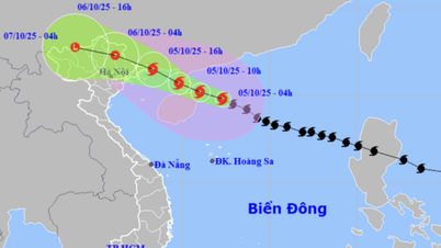
Due to the influence of storm number Matmo, the northern area of Bac Bo Gulf (including Bach Long Vy, Van Don, Co To, Cat Hai and Hon Dau island) winds gradually increased to level 6 - 7, then increased to level 8 - 9, the area near the storm center passed level 10 - 12, gusting to level 15. Waves were 2 - 4 m high, the area near the storm center was 3 - 5 m, the sea was rough, very dangerous for ships and boats.
Storm Matmo brings heavy rain and strong winds from tonight
The National Center for Hydro-Meteorological Forecasting warns that from tonight, October 5 to noon, October 6, on land in coastal areas from Quang Ninh - Hung Yen and Lang Son province, winds will gradually increase to level 6 - 7, near the storm center, level 8 - 10, gusting to level 11 - 12. Storm winds at this level will break tree branches, blow off roofs, causing damage to houses, and it is impossible to go against the wind.
The communes and wards in the northeast of Quang Ninh province are likely to have strong winds of level 9 - 10, gusting to level 12 - 13. The remaining communes and wards of Quang Ninh province and the coastal areas of Hai Phong city are likely to have strong winds of level 8 - 9, gusting to level 10 - 11.
The coastal communes and wards of Hung Yen province and the northern border communes of Lang Son province are likely to have strong winds of level 6 - 8, gusting to level 9 - 10. The northeastern area of Bac Ninh province (formerly Bac Giang province) and the eastern part of Cao Bang province are likely to have strong winds of level 6 - 7, gusting to level 8 - 9.
It is forecasted that from the night of October 5 to the end of the night of October 7, storm Matmo will begin to cause widespread heavy rain in the mountainous and midland areas of the North, with rainfall ranging from 150 - 250 mm, with some places experiencing very heavy rain over 400 mm, with the risk of heavy rain, with rainfall over 150 mm/3 hours causing localized flooding. The Northern Delta and Thanh Hoa regions will have moderate to heavy rain with rainfall ranging from 70 - 150 mm, with some places experiencing very heavy rain over 200 mm.
During the heavy rains caused by storm Matmo (storm No. 11) in the coming days, mountainous and midland provinces in the North are at high risk of flash floods and landslides./.
According to Thanh Nien Newspaper
Source: https://thanhnien.vn/bao-matmo-bat-dau-suy-yeu-dang-tien-vao-vinh-bac-bo-185251005171113428.htm
Source: https://baolongan.vn/bao-matmo-bat-dau-suy-yeu-dang-tien-vao-vinh-bac-bo-a203848.html


![[Photo] Opening of the 13th Conference of the 13th Party Central Committee](https://vphoto.vietnam.vn/thumb/1200x675/vietnam/resource/IMAGE/2025/10/6/d4b269e6c4b64696af775925cb608560)


Comment (0)