
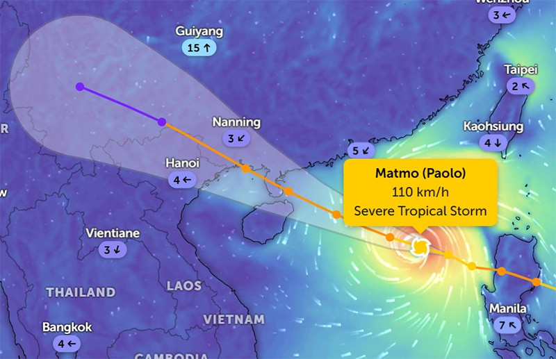
Location of storm No. 11 at 6:30 a.m. on October 4. (Zoom Earth photo)
The strongest wind in the storm center: Level 11 (103-117km/h), gust level 14.
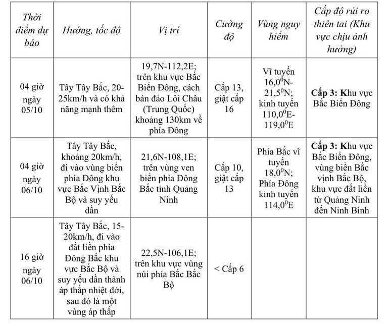
Forecast in the next 3 hours, the storm moves west-northwest, speed about 20-25km/hour.
Storm forecast (in the next 24 to 60 hours):
Strong winds, big waves, rising water
At sea: In the northern East Sea, there are strong winds of level 8-10, near the storm center level 11-13, gusts of level 16, waves 4.0-6.0m high, near the storm center 6.0-8.0m, very rough seas ( extremely destructive, extremely strong waves. Sinking large tonnage ships) .
From the afternoon of October 5, the sea area east of the northern Gulf of Tonkin (including Bach Long Vi special zone) has winds gradually increasing to level 6-7, then increasing to level 8-9. From the evening of October 5, the northern Gulf of Tonkin (including Bach Long Vi special zone, Van Don, Co To, Cat Hai and Hon Dau island) has winds gradually increasing to level 8-9, waves 2-4m high, the area near the storm center has levels 10-11, gusts of level 14, waves 3-5m high, rough seas ( rough seas, very dangerous for ships) .
Storm surge and flood warning for coastal areas: Coastal areas and islands in Quang Ninh- Hai Phong provinces have storm surges of 0.4-0.6m. Beware of flooding in low-lying coastal areas and river mouths due to surges and big waves from the afternoon and evening of October 5.
Weather warning at sea, coastal mainland during storm is extremely dangerous, unsafe for any vehicle, construction operating in the danger zone such as: cruise ships, passenger ships, transport ships, cages, rafts, aquaculture areas, dykes, embankments, coastal routes. Vehicles are highly likely to capsize, be destroyed; flooded due to strong winds, big waves and rising sea levels.
On land: From the night of October 5, on land from Quang Ninh to Ninh Binh, winds will gradually increase to level 6-8, near the storm center, level 9-10 ( winds can knock down trees, houses, electric poles, causing very heavy damage ). Inland areas in the northeast, winds will be strong at level 6, in some places level 7, gusting to level 8-9.
Heavy rain
From the night of October 5 to the end of the night of October 7, in the Northern region, Thanh Hoa and Nghe An, there will be heavy to very heavy rain with common rainfall of 100-200mm, locally over 300mm, especially in the mountainous and midland areas of the North, it will be common from 150-250mm, locally over 400mm. Warning of the risk of heavy rain (>200mm/3 hours).
Nhandan.vn
Source: https://nhandan.vn/bao-so-11-matmo-giat-cap-14-di-chuyen-nhanh-theo-huong-tay-tay-bac-post912836.html
![[Photo] General Secretary To Lam attends the 8th Congress of the Central Public Security Party Committee](https://vphoto.vietnam.vn/thumb/1200x675/vietnam/resource/IMAGE/2025/10/4/79fadf490f674dc483794f2d955f6045)
![[Infographic] Notable numbers after 3 months of "reorganizing the country"](https://vphoto.vietnam.vn/thumb/1200x675/vietnam/resource/IMAGE/2025/10/4/ce8bb72c722348e09e942d04f0dd9729)


![[Photo] Prime Minister Pham Minh Chinh chairs meeting to deploy overcoming consequences of storm No. 10](https://vphoto.vietnam.vn/thumb/1200x675/vietnam/resource/IMAGE/2025/10/3/544f420dcc844463898fcbef46247d16)
![[Photo] Students of Binh Minh Primary School enjoy the full moon festival, receiving the joys of childhood](https://vphoto.vietnam.vn/thumb/1200x675/vietnam/resource/IMAGE/2025/10/3/8cf8abef22fe4471be400a818912cb85)


Comment (0)