
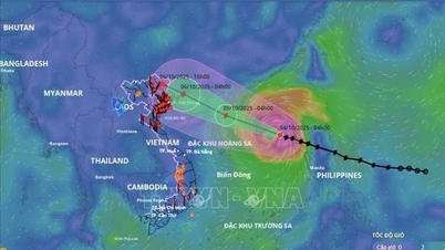
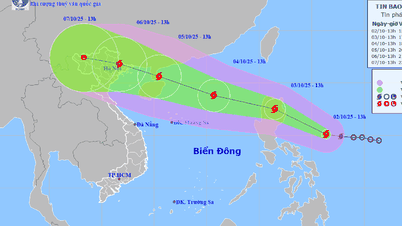
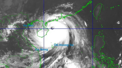
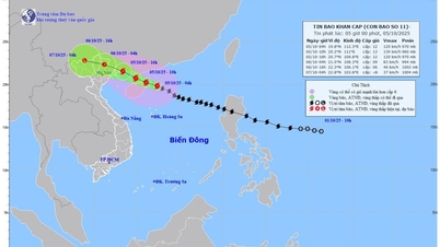
At that time, the storm will reach very strong intensity, with winds reaching level 15-16, gusting to level 17, causing a level 4 natural disaster risk in the northeastern part of the East Sea.

According to Mr. Hoang Phuc Lam, Deputy Director of the National Center for Hydro-Meteorological Forecasting, this is a very high risk level, capable of sinking large ships, causing dikes to break, and uprooting ancient trees.
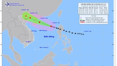
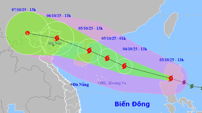
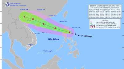
The National Center for Hydro-Meteorological Forecasting said that at 1 p.m. on September 20, the storm's center was at about 16.7 degrees North latitude - 129.1 degrees East longitude, about 730km east of Luzon Island (Philippines).
The storm is currently at level 12 (118-133km/h), gusting to level 15, moving in the West Northwest direction at a speed of 5-10km/h.

Vietnam's meteorological agency forecasts that at 1 p.m. on September 21, the storm's center will be 490km east-northeast of Luzon Island, with a level 13-14 intensity, gusting to level 17.
By September 22, the storm approached the North of Luzon Island, reaching level 15-16, gusting over level 17. At 1 p.m. on September 23, the storm entered the Northeast East Sea with winds of level 15-16, gusting over level 17, causing violent seas.
After that, according to the National Center for Hydro-Meteorological Forecasting, Ragasa will move westward at a speed of about 20km/hour and gradually weaken. There is a high possibility that the storm will continue to move quickly towards the Hong Kong area (China).
Source: https://www.sggp.org.vn/du-bao-bao-ragasa-vao-bien-dong-voi-rui-ro-thien-tai-cap-4-post813931.html
![[Photo] Bustling Mid-Autumn Festival at the Museum of Ethnology](https://vphoto.vietnam.vn/thumb/1200x675/vietnam/resource/IMAGE/2025/10/4/da8d5927734d4ca58e3eced14bc435a3)


![[Photo] General Secretary To Lam attends the 8th Congress of the Central Public Security Party Committee](https://vphoto.vietnam.vn/thumb/1200x675/vietnam/resource/IMAGE/2025/10/4/79fadf490f674dc483794f2d955f6045)

![[Photo] Solemn opening of the 8th Congress of the Central Public Security Party Committee, term 2025-2030](https://vphoto.vietnam.vn/thumb/1200x675/vietnam/resource/IMAGE/2025/10/4/f3b00fb779f44979809441a4dac5c7df)


![[VIDEO] Summary of Petrovietnam's 50th Anniversary Ceremony](https://vphoto.vietnam.vn/thumb/402x226/vietnam/resource/IMAGE/2025/10/4/abe133bdb8114793a16d4fe3e5bd0f12)

![[VIDEO] GENERAL SECRETARY TO LAM AWARDS PETROVIETNAM 8 GOLDEN WORDS: "PIONEER - EXCELLENT - SUSTAINABLE - GLOBAL"](https://vphoto.vietnam.vn/thumb/402x226/vietnam/resource/IMAGE/2025/7/23/c2fdb48863e846cfa9fb8e6ea9cf44e7)


Comment (0)