
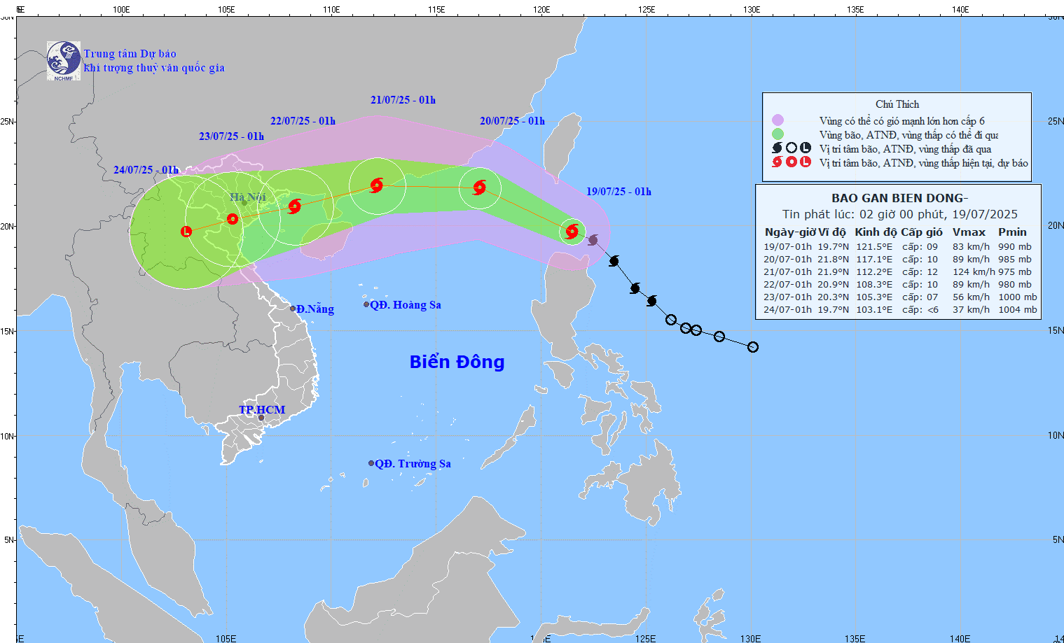
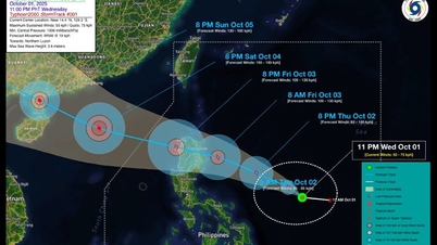
Forecast of the path of storm Wipha at 2:00 a.m. on July 19, 2025. (Photo: nchmf)
According to the National Center for Hydro-Meteorological Forecasting, at 1:00 a.m. on July 19, storm Wipha was at about 19.7 degrees North latitude - 121.5 degrees East longitude, in the sea north of Luzon Island (Philippines). The storm moved northwest at a speed of about 20 km/h; the strongest wind was level 9 (75-88 km/h), gusting to level 11.
Forecast at about 1am tomorrow (July 20), the storm will enter the East Sea. The center of the storm is at 21.8 degrees North latitude - 117.1 degrees East longitude; in the northeastern sea area of the North East Sea; about 760km east of Leizhou Peninsula (China). Intensity level 10, gust level 12 and likely to strengthen.
At 1:00 a.m. on July 21, the storm was moving mainly westward at about 20 km/h, with its center about 210 km east-northeast of Leizhou Peninsula (China). Its intensity was level 11-12, with gusts of level 14.
At about 1:00 a.m. on July 22, the storm moved in a West-Southwest direction, located at 20.9 degrees North latitude - 108.3 degrees East longitude, in the Gulf of Tonkin and gradually weakened.
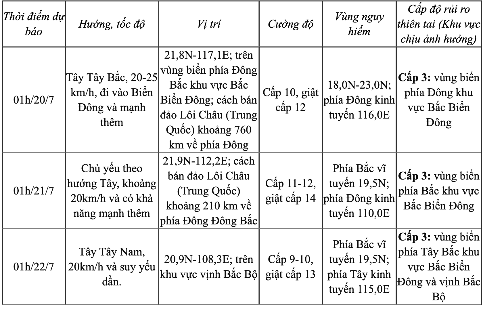
Storm forecast (in the next 24 to 72 hours).
Warning: From the next 72 to 120 hours, the storm will move mainly in the West Southwest direction, 10-15km per hour, gradually weakening.
Due to the impact of the storm circulation, the eastern sea area of the North East Sea has winds gradually increasing to level 6-7, near the storm center level 8-10, gusting to level 12. Waves are 3-5m high. The sea is very rough. Ships in the danger zone are at high risk of being affected by whirlwinds, strong winds and big waves.
NDS
Source: https://baothanhhoa.vn/du-bao-sang-mai-20-7-bao-wipha-di-vao-bien-dong-tro-thanh-con-bao-so-3-255263.htm
![[Photo] Hanoi morning of October 1: Prolonged flooding, people wade to work](https://vphoto.vietnam.vn/thumb/1200x675/vietnam/resource/IMAGE/2025/10/1/189be28938e3493fa26b2938efa2059e)

![[Photo] Keep your warehouse safe in all situations](https://vphoto.vietnam.vn/thumb/1200x675/vietnam/resource/IMAGE/2025/10/1/3eb4eceafe68497989865e7faa4e4d0e)


![[Photo] President of the Cuban National Assembly visits President Ho Chi Minh's Mausoleum](https://vphoto.vietnam.vn/thumb/1200x675/vietnam/resource/IMAGE/2025/10/1/39f1142310fc4dae9e3de4fcc9ac2ed0)


Comment (0)