
Urgent flood news on rivers in the North
Floods on Lo River (Tuyen Quang), Cau River, Thuong River (Bac Ninh), Thai Binh River (Hai Phong) are rising. Due to the operation and regulation of upstream reservoirs and upstream floods, the water level in the downstream of the Red River at Hanoi station is rising slowly, while the flood in the downstream of Ca River (Nghe An) has little change.
Water level at 1:00 a.m. on October 2 on Lo River at Tuyen Quang station was 26.29m, 0.29m above alarm level 3; on Cau River at Dap Cau station was 6.11m, 0.19m below alarm level 3; on Thuong River at Phu Lang Thuong station was 6.21m, 0.09m below alarm level 3; on Thai Binh River at Pha Lai station was 5.03m, 0.03m above alarm level 2; on Red River at Ha Noi station was 9.56m, 0.06m above alarm level 1; on Ca River at Nam Dan station was 7.35m, 0.45m above alarm level 2.
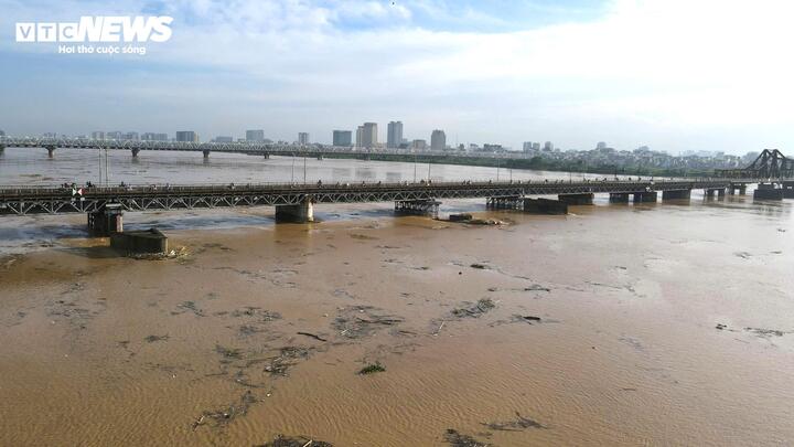
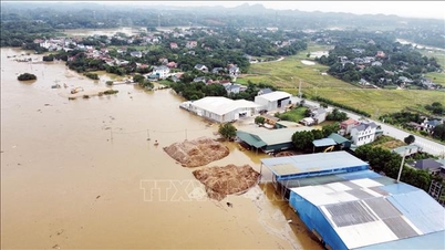
The flood water of the Red River passing through Hanoi rose, submerging the sandbank and alluvial areas.
In the next 6 hours, floods on Lo River and Thuong River are likely to peak at BĐ3.
It is forecasted that in the next 12 hours, flood on Cau River will peak at level 3, flood on Thai Binh River will peak above level 2, flood on Lo River will decrease and be below level 3, flood in the downstream of Ca River will gradually decrease and be above level 2.
In the next 12-24 hours, floods on Lo, Cau, and Thuong rivers will continue to decrease and be below level 3; floods on Thai Binh River will continue to decrease to level 2; floods in the downstream of Ca River will decrease and be above level 2.
In the next 24 hours, the flood downstream of the Red River at Hanoi station will rise slowly and be above level 1; the flood on the Luc Nam River ( Bac Ninh ) at Luc Nam station will continue to fall and be above level 1, and the Ma River (Thanh Hoa) at Giang station will continue to fall below level 1.
The Meteorological Agency warned of flooding in low-lying areas along rivers and urban areas in the Northern region, from Thanh Hoa to Nghe An. Flash floods and landslides on steep slopes in the mountainous areas of the Northern region, from Thanh Hoa to Nghe An.
News of tropical depression near the East Sea
At 1:00 a.m. on October 2, the center of the tropical depression was located in the sea east of the Philippines. The strongest wind near the center of the tropical depression was level 7 (50-61 km/h), gusting to level 9, moving in the West Northwest direction, at a speed of about 15 km/h.
It is forecasted that in the next 24 hours, the tropical depression in the sea east of Luzon Island (Philippines) will continue to move in the West Northwest direction, at a faster speed of about 20km/h, and may strengthen into a storm with a level 8 intensity, gusting to level 10.
Around the evening of October 3, the storm entered the East Sea and became the 11th storm in 2025.
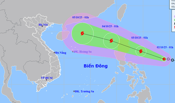
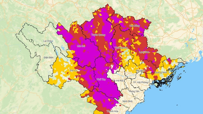
Map predicting the path and area of influence of the tropical depression. (Source: NCHMF)
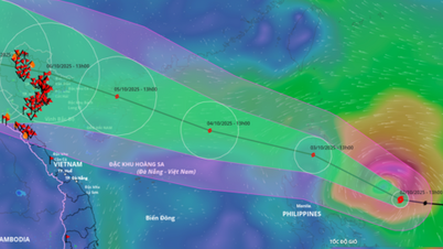
At 1:00 a.m. on October 4, the center of storm No. 11 was located in the eastern sea of the North East Sea, moving rapidly in the West Northwest direction, about 25km per hour, and could strengthen with the strongest wind near the storm center at level 10, gusting to level 12.
From the next 48 to 72 hours, storm No. 11 will move in the West Northwest direction, about 25km per hour and continue to strengthen.
Impact of the tropical depression after strengthening into a storm, from the afternoon of October 3, the sea area east of the North East Sea area has gradually increased to level 6-7, then increased to level 8, the area near the storm center has strong level 9-10, gusts to level 12, waves 4-6m high, very rough seas.
Around October 4-6, the North East Sea (including Hoang Sa special zone) is likely to be affected by strong winds of level 11-12, gusting to level 15.
Vtcnews.vn
Source: https://vtcnews.vn/canh-bao-lu-tren-nhieu-song-o-mien-bac-sap-dat-dinh-ar968752.html


![[Photo] Binh Trieu 1 Bridge has been completed, raised by 1.1m, and will open to traffic at the end of November.](https://vphoto.vietnam.vn/thumb/1200x675/vietnam/resource/IMAGE/2025/10/2/a6549e2a3b5848a1ba76a1ded6141fae)


Comment (0)