
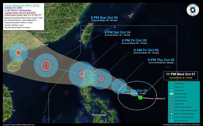
Forecast path of storm No. 11. Photo: typhoon2000.ph
On the morning of October 2, the Philippine Atmospheric, Geophysical and Astronomical Services Administration (PAGASA) issued an emergency storm bulletin stating that tropical depression Paolo had intensified into a storm. At 4:00 a.m. on October 2, the center of the storm was at 14.6 degrees North latitude, 128.2 degrees East longitude, about 705km east of Quezon province (Philippines).
Storm Paolo is moving in the West Northwest direction, speed 20 km/h, strongest wind near the storm center reaches 65 km/h, gusts 80 km/h, central pressure 1000 hPa. Storm wind range 250km from the storm center.
Storm Paolo is forecast to continue to strengthen, possibly reaching tropical storm level, or even becoming a typhoon after crossing Luzon Island and entering the East Sea. At that time, this will be the 11th storm of the 2025 rainy season in the East Sea, with the international name Matmo.
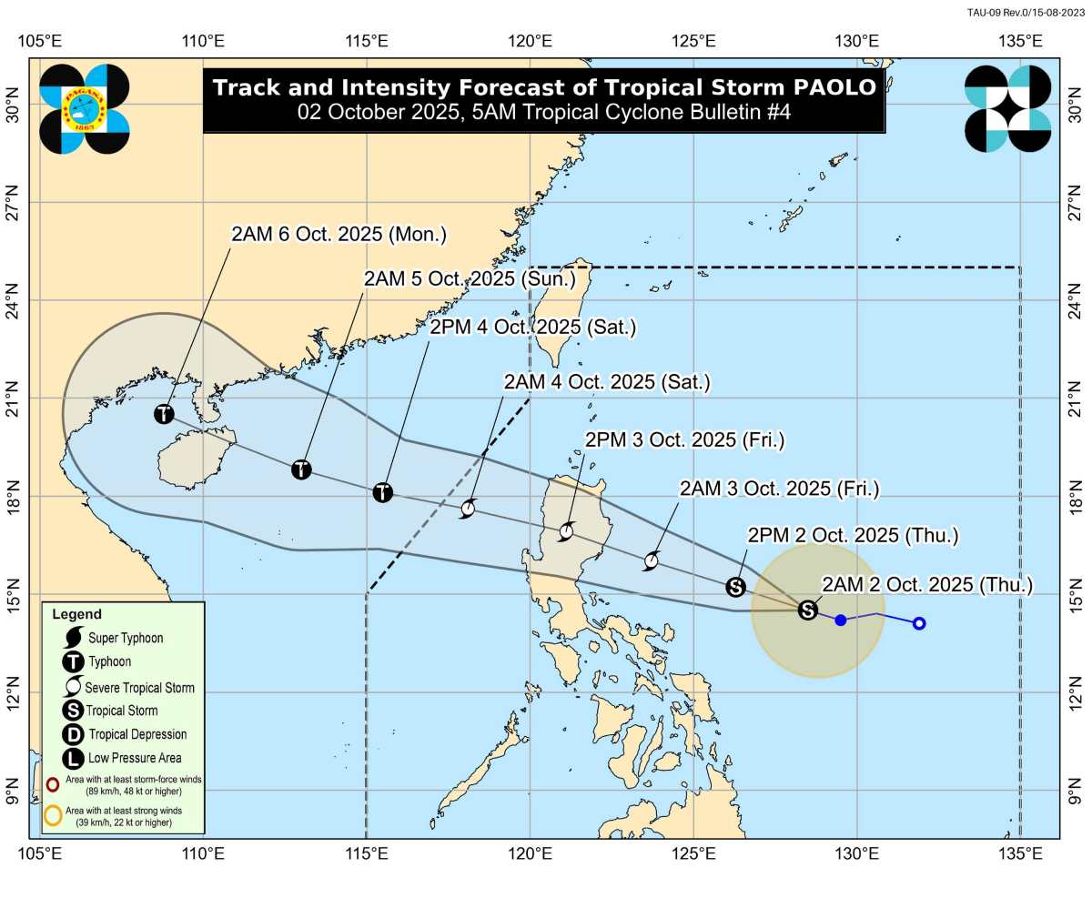
Forecast of the path of storm No. 11 when entering the East Sea. Photo: PAGASA
PAGASA has placed 22 areas in the Philippines under storm alert level 1. Although Paolo may make landfall in Isabela or Aurora (Northern Luzon) on the morning of October 3, heavy rains , strong winds and storm surges will affect many other areas outside the storm's center.
After passing Luzon, Paolo is forecast to enter the East Sea on the afternoon of October 3, moving west-northwest. The storm is likely to strengthen and directly affect the northern part of the East Sea on October 4.
The Vietnam National Center for Hydro-Meteorological Forecasting predicts that from the afternoon of October 3, the eastern sea area of the North East Sea will have winds gradually increasing to level 6-7; then increasing to level 8, the area near the storm's center will have strong winds of level 9-10, gusting to level 12, waves 4.0-6.0m high. The sea will be very rough.
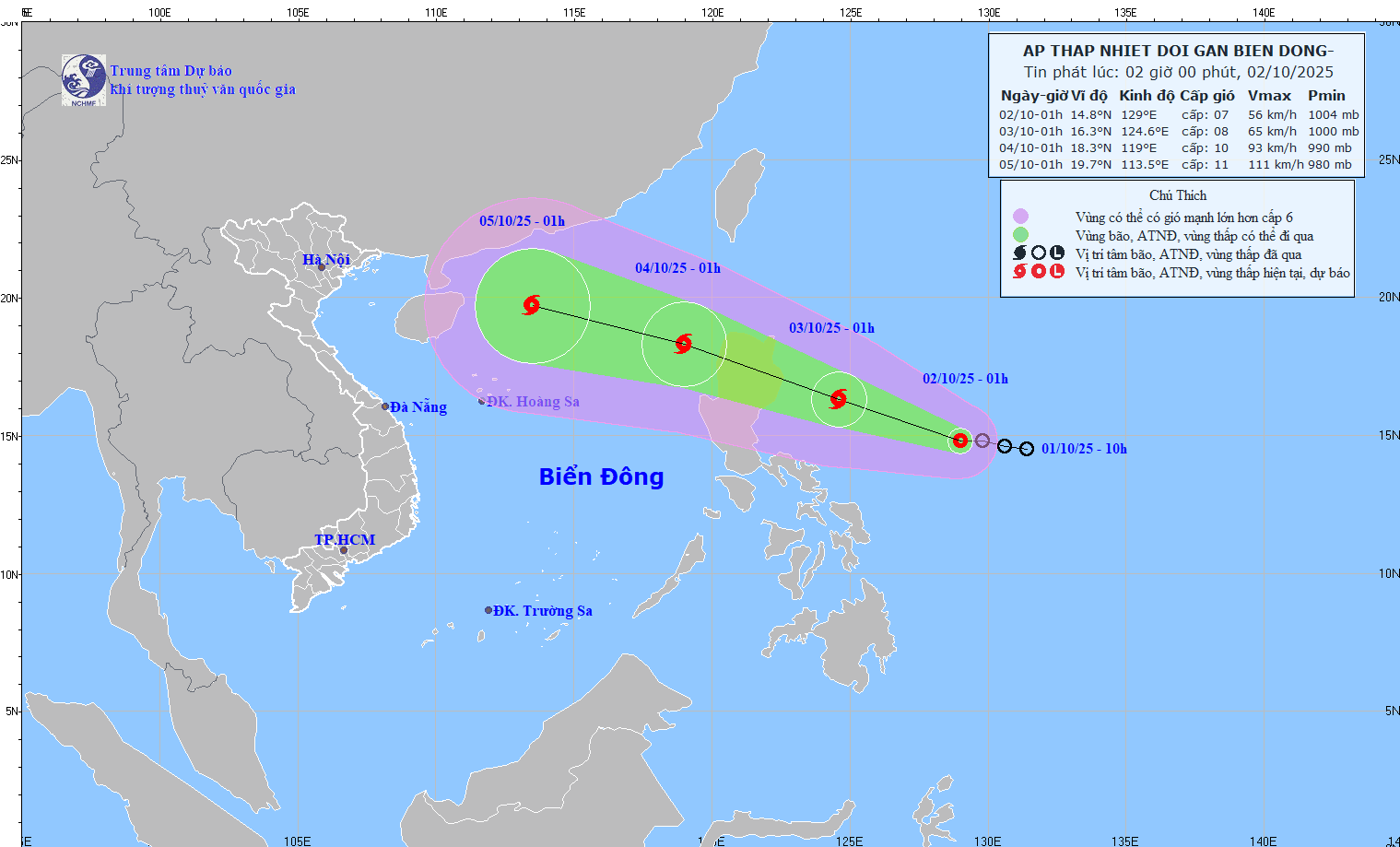
Forecast of the Vietnam National Center for Hydro-Meteorological Forecasting
During October 4-6, the North East Sea area (including Hoang Sa special zone) is likely to be affected by strong winds of level 11-12, gusting to level 15.
Rain forecast: From October 4-6, mountainous and midland provinces in the North are likely to have very heavy rain, with the risk of flash floods and landslides.
Northern Delta: Strong winds of level 6-7, gusts of level 8-9, accompanied by intermittent heavy rain. Hanoi and the delta provinces need to be alert for urban flooding.
In the North Central region, Thanh Hoa, Nghe An, and Ha Tinh provinces may be indirectly affected by the circulation of storm No. 11. Moderate to heavy rain, with very heavy rain in some places, is forecast on October 5-7.
Northern mountainous areas and North Central regions be on alert for flash floods and landslides.
Laodong.vn
Source: https://laodong.vn/the-gioi/bao-so-11-hinh-thanh-nguy-co-tang-cap-manh-khi-vao-bien-dong-ngay-mai-1584506.ldo

![[Photo] Binh Trieu 1 Bridge has been completed, raised by 1.1m, and will open to traffic at the end of November.](https://vphoto.vietnam.vn/thumb/1200x675/vietnam/resource/IMAGE/2025/10/2/a6549e2a3b5848a1ba76a1ded6141fae)


Comment (0)