
The National Center for Hydro-Meteorological Forecasting has just released its assessment of the weather situation across the country in the next 7 days (from September 20-26). In particular, during this period, the weather will be affected by 2 consecutive storms appearing in the East Sea, including one that will affect our mainland.
Specifically, around the late afternoon and evening of September 19, storm No. 8 Mitag made landfall in the southern part of Guangdong Province (China). After that, the storm quickly weakened into a tropical depression, then a low pressure area on September 20. However, the circulation from this storm will cause heavy rain in the North between September 22 and 23.
Notably, a storm with the international name Ragasa is active in the Northwest Pacific Ocean, about 800km east of Luzon Island (Philippines).
Forecast, the storm moves to the Northwest, then changes direction to the West Northwest, moving speed gradually faster and intensity continuously increasing.
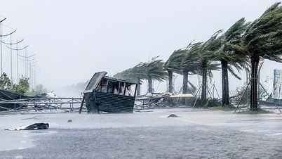
Around September 23, storm Ragasa is likely to enter the eastern sea area of the North East Sea, with a level 14-16 intensity, gusting over level 17 (super typhoon level). This is the 9th storm in 2025, forecast to affect our mainland.
Therefore, during the period from September 20-26, 2025, the weather across the country will have many strong fluctuations. Specifically:
Northern Region
From September 20-21 and September 24: Sunny days, showers and thunderstorms at night in some places.
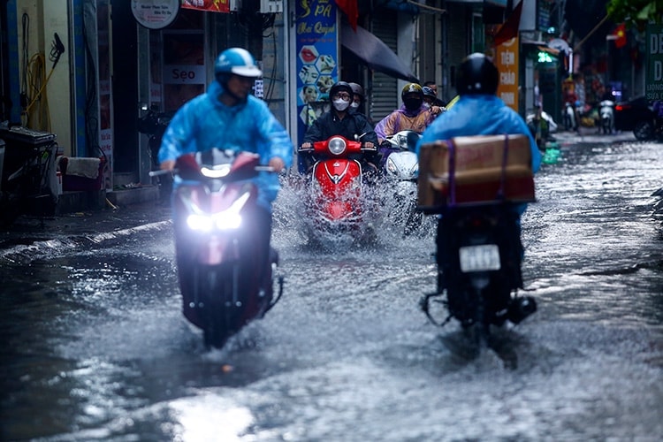
From September 22-23: rain, moderate rain, locally heavy to very heavy rain.
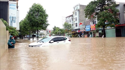
From September 25-26: there is a possibility of widespread heavy rain.
Water levels on small streams and main rivers in the Red - Thai Binh system are likely to flood in the last 1-2 days.
Central region from Thanh Hoa to Hue
From September 20-21 and September 24: there will be showers and thunderstorms in some places, especially in the South in the late afternoon and evening there will be scattered showers and thunderstorms.
From September 22-23: scattered showers and thunderstorms in the evening.
From around September 25-26 there is a possibility of widespread heavy rain.
Hanoi area
From September 20-21 and September 24: Sunny days, showers and thunderstorms at night in some places.
From September 22-23: scattered showers and thunderstorms, locally heavy rain.
From September 25-26: there is a possibility of widespread heavy rain.
Wave forecast
From September 20-21, wave height fluctuated 2m in sea areas.
From September 22 to 27, due to the influence of storm Ragasa, wave heights in sea areas tend to increase. In the North East Sea area (including Hoang Sa special zone), wave heights fluctuate from 9-11 m; in the Central and South East Sea area (including Truong Sa special zone), and in the Gulf of Tonkin, wave heights fluctuate from 3-6 m; in the area from Quang Tri to Ca Mau, wave heights are commonly 2-4 m.
PVSource: https://baohaiphong.vn/hai-con-bao-lien-tiep-thoi-tiet-ca-nuoc-nhieu-noi-bien-dong-di-thuong-521267.html


![[Photo] Discover unique experiences at the first World Cultural Festival](https://vphoto.vietnam.vn/thumb/1200x675/vietnam/resource/IMAGE/2025/10/11/1760198064937_le-hoi-van-hoa-4199-3623-jpg.webp)


![[Photo] General Secretary attends the parade to celebrate the 80th anniversary of the founding of the Korean Workers' Party](https://vphoto.vietnam.vn/thumb/1200x675/vietnam/resource/IMAGE/2025/10/11/1760150039564_vna-potal-tong-bi-thu-du-le-duyet-binh-ky-niem-80-nam-thanh-lap-dang-lao-dong-trieu-tien-8331994-jpg.webp)


![[Photo] General Secretary attends the 80th Anniversary of the Traditional Day of the Armed Forces of Military Region 4](https://vphoto.vietnam.vn/thumb/402x226/vietnam/resource/IMAGE/2025/10/12/1760265970415_image.jpeg)


Comment (0)