
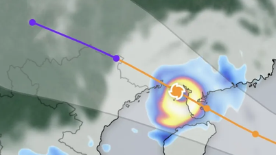
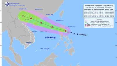
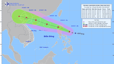
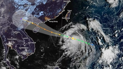
Updated as of the afternoon of August 17, the center of the tropical depression was at about 17.4 degrees North latitude - 111.1 degrees East longitude, in the northwest sea of Hoang Sa special zone. The strongest wind near the center of the tropical depression was level 6, gusting to level 8. The tropical depression moved northwest at a speed of about 15km/hour.

Vietnam's meteorological agency forecasts that the tropical depression will continue to move northwest and on the afternoon of August 18 will enter the northern Gulf of Tonkin with winds of level 6, gusting to level 8. After that, the tropical depression will move northwest, entering the southern part of Guangxi province (China).
Under the impact of the tropical depression, the Northwestern East Sea, including Hoang Sa, and the Gulf of Tonkin, including Bach Long Vi and Co To islands, are directly affected by winds of level 6-7, gusts of level 8-9, and waves of 2-3.5m high. Ships operating in these areas will encounter large waves.
Many places have rain and wind, which may last a long time.
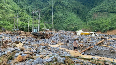
On the afternoon of August 17, weather experts warned that from now until the night of August 18, the Northern and North Central regions may experience very heavy rain with rainfall ranging from 150-300mm. The risk of landslides and flash floods in many mountainous areas in this region is very high.
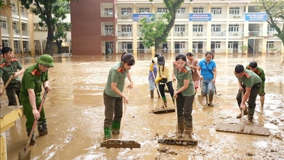
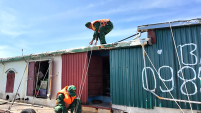
, afternoon of August 17. Photo: QUAN THUYEN")
According to satellite data from the meteorological agency and data from the automatic rain measuring system Vrain, on August 17, many places in the North had rain, moderate rain.

Thanh Hoa - Nghe An - Ha Tinh have the heaviest rain
However, the North Central region was the epicenter of heavy rain. Of which, Vinh Meteorological Station (Nghe An province) measured the highest rainfall in the country with 234.6mm. Other meteorological stations such as Ky Thinh (Ha Tinh province) recorded 180.2mm, Mai Lam (Thanh Hoa province) 132.2mm.
On August 17, the National Center for Hydro-Meteorological Forecasting continuously issued warnings of the risk of flooding and flash floods in many localities.
Many localities also had heavy rain such as Quang Ngai 128.8mm, Hue 105.2mm, Lam Dong 96.4mm... The rain was basically spread evenly in all three regions of North - Central - South.
In the South and Central Highlands, rain is mainly due to the impact of the Southwest monsoon combined with tropical depression. However, rain in this area only appears sporadically, with some areas having heavy rain but not much.
Areas with heavy rain are concentrated in Tay Ninh, Dong Nai, Dong Thap, Vinh Long, and Ho Chi Minh City. In the Central Highlands, rain is concentrated in Lam Dong, Dak Lak, Gia Lai...

Meanwhile, the National Center for Hydro-Meteorological Forecasting forecasts that from the evening of August 17 to the night of August 18, Thanh Hoa and Nghe An will have moderate to heavy rain, with rainfall of 50-110mm, locally over 250mm. Ha Tinh and Quang Tri will also have moderate to heavy rain during the same period, with rainfall of 40-80mm, in some places over 200mm.
On August 18 and 19, the Northeast region continued to have moderate to heavy rain, with rainfall of 40-120mm, locally over 250mm. From the night of August 17 to August 18, the Northwest region, the area from Hue to Lam Dong and the entire South had scattered showers and thunderstorms, with rainfall of 15-30mm, in some places over 80mm. In the Northeast region alone, on the night of August 17, some places reached 70mm.

From the night of August 19 to the morning of August 20, the North and Thanh Hoa continue to have moderate to heavy rain, with rainfall of 30-60mm, and in some places over 150mm.
Source: https://www.sggp.org.vn/ngay-mai-18-8-ap-thap-nhiet-doi-vao-vinh-bac-bo-post808856.html

![[Photo] Prime Minister Pham Minh Chinh chairs the Government's online conference with localities](https://vphoto.vietnam.vn/thumb/1200x675/vietnam/resource/IMAGE/2025/10/5/264793cfb4404c63a701d235ff43e1bd)


![[Photo] Prime Minister Pham Minh Chinh launched a peak emulation campaign to achieve achievements in celebration of the 14th National Party Congress](https://vphoto.vietnam.vn/thumb/1200x675/vietnam/resource/IMAGE/2025/10/5/8869ec5cdbc740f58fbf2ae73f065076)


![[VIDEO] Summary of Petrovietnam's 50th Anniversary Ceremony](https://vphoto.vietnam.vn/thumb/402x226/vietnam/resource/IMAGE/2025/10/4/abe133bdb8114793a16d4fe3e5bd0f12)

![[VIDEO] GENERAL SECRETARY TO LAM AWARDS PETROVIETNAM 8 GOLDEN WORDS: "PIONEER - EXCELLENT - SUSTAINABLE - GLOBAL"](https://vphoto.vietnam.vn/thumb/402x226/vietnam/resource/IMAGE/2025/7/23/c2fdb48863e846cfa9fb8e6ea9cf44e7)


Comment (0)