
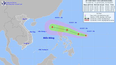
The National Center for Hydro-Meteorological Forecasting said that at 10 p.m. on September 23, the center of the super typhoon was about 550 km east of Leizhou Peninsula (China), with the strongest wind speed of 201 km/h, level 15-16, gusting to level 17, and moving west-northwest at a speed of about 20 km/h.
The storm is entering a weakening phase due to the impact of continental high pressure, terrain friction and some unfavorable meteorological conditions. Forecast at 10pm tomorrow, the storm is in the sea along the east coast of Leizhou peninsula (China); about 300km east of Mong Cai ( Quang Ninh ), the strongest wind is level 12-13, gusting to level 16.

Forecast of the direction and affected area of storm Ragasa at 10:00 p.m. on September 23. Photo: Disaster monitoring system
At 10:00 p.m. on September 25, the storm was on the coast of Quang Ninh - Hai Phong , with the strongest wind at level 8-9, gusting to level 11. Ragasa then moved inland and weakened into a tropical depression and low pressure area in the Northwest.
The Japan Meteorological Agency forecasts that on September 24, the storm will enter near the Leizhou Peninsula with winds of 162 km/h and then enter the Gulf of Tonkin. The Hong Kong Meteorological Agency predicts that the storm will move deep into the north of Leizhou and then into the Gulf of Tonkin, with the center of the storm hitting Quang Ninh province on September 25.
Due to the storm's influence, the northern East Sea has strong winds of level 10-13, the area near the storm's eye has winds of level 14-16, gusts of over level 17, and waves over 10 meters high. From September 24, the eastern sea of the northern Gulf of Tonkin (including Bach Long Vi special zone) will have winds gradually increasing to level 6-7, gusts of level 9.
From the evening and night of September 24, the northern Gulf of Tonkin (including Bach Long Vy, Van Don, Co To, Cat Hai and Hon Dau islands) will experience winds gradually increasing to level 8, waves 2-4 m high, near the storm center will experience winds of level 9-10, gusts of level 12, waves 3-5 m high. The water level in the coastal areas of Quang Ninh province will rise by 0.4-0.6 m due to the storm.
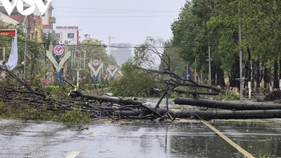
On land, from early morning on September 25, the coastal areas of Quang Ninh - Ninh Binh will have winds gradually increasing to level 6-7, near the storm center level 8-9, gusting to level 11; deep inland in the Northeast, there will be strong winds of level 5, in some places level 6, gusting to level 7-8.
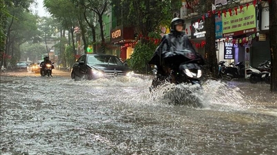
The storm will cause rain from tomorrow night until the end of the night of September 26. The North, Thanh Hoa and Nghe An will see widespread rain of 100-250 mm, locally over 400 mm. Heavy rain is likely to cause flooding in low-lying areas; flash floods on small rivers and streams, and landslides on steep slopes.

Satellite image of super typhoon Ragasa at 10 p.m. on September 22. Photo: NCHMF
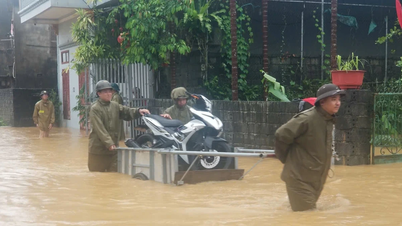
Today, the Prime Minister signed an official dispatch requesting the Secretaries and Chairmen of the People's Committees of provinces and cities from Ha Tinh and above to focus on directing measures to respond to the super typhoon, prioritizing ensuring the safety of people's lives; safety for ships operating at sea and along the coast; protecting houses, warehouses, factories, headquarters of agencies, units, educational and medical facilities, dyke systems, dams and lakes.
The Government also requested provinces and cities to review plans and be ready to organize evacuation and relocation of residents to ensure safety before the storm makes landfall, and to deploy rescue work when bad situations occur.
The Prime Minister requested ministries and branches to deploy storm prevention according to their functions and tasks with the view of not being negligent or subjective, organizing monitoring, updating, grasping the situation, deploying response measures with the most drastic spirit, anticipating the worst scenario, not being passive or surprised.

Hurricane wind levels. Graphics: Hoang Khanh
Storm Ragasa formed on September 18 from a tropical depression off the coast of the Philippines. Three days later, it increased to a super typhoon level 8 and reached a maximum level 17 with winds of 221 km/h in the East Sea on the evening of September 22. Ragasa surpassed Yagi in 2024 to become the strongest storm in the East Sea in the past 70 years.
Source vnexpress.net
Source: https://baophutho.vn/sieu-bao-ragasa-giam-cap-240023.htm


![[Photo] Hanoi morning of October 1: Prolonged flooding, people wade to work](https://vphoto.vietnam.vn/thumb/1200x675/vietnam/resource/IMAGE/2025/10/1/189be28938e3493fa26b2938efa2059e)


![[Photo] President Luong Cuong receives President of the Cuban National Assembly Esteban Lazo Hernandez](https://vphoto.vietnam.vn/thumb/1200x675/vietnam/resource/IMAGE/2025/9/30/4d38932911c24f6ea1936252bd5427fa)
![[Photo] The 1st Congress of Phu Tho Provincial Party Committee, term 2025-2030](https://vphoto.vietnam.vn/thumb/1200x675/vietnam/resource/IMAGE/2025/9/30/1507da06216649bba8a1ce6251816820)
![[Photo] Panorama of the cable-stayed bridge, the final bottleneck of the Ben Luc-Long Thanh expressway](https://vphoto.vietnam.vn/thumb/1200x675/vietnam/resource/IMAGE/2025/9/30/391fdf21025541d6b2f092e49a17243f)


Comment (0)