
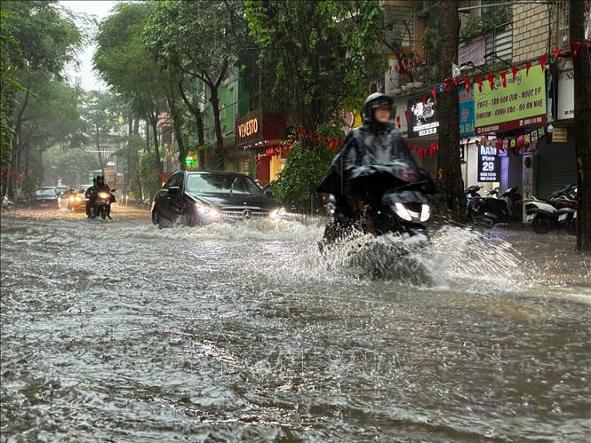
Quan Thanh - Yen Ninh street section ( Hanoi ) is deeply flooded, making it difficult for vehicles to move (photo taken at noon on September 30, 2025). Photo: Le Dong/VNA
It is forecasted that from now until the next 3 hours, the above areas will have showers and thunderstorms, then expanding to the wards: Yen Nghia, Phu Luong, Kien Hung, Ha Dong and other inner-city areas of Hanoi. During thunderstorms, there is a possibility of tornadoes, lightning and strong gusts of wind.
According to the National Center for Hydro-Meteorological Forecasting, at 7:00 a.m. on October 1, on the Thao River at Yen Bai station, the water level was 32.81 m, 0.81 m above alert level 3.
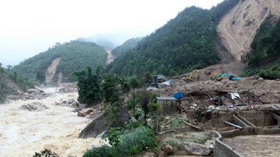
Floods on the Thao River (Lao Cai), Luc Nam River ( Bac Ninh ), and Ma River (Thanh Hoa) are receding. Floods downstream of the Ca River (Nghe An) are fluctuating at their peak above alert level 2.
Currently, floods on Lo River (Tuyen Quang), Cau River, Thuong River (Bac Ninh), Thai Binh River (Hai Phong) are rising. Due to the influence of upstream reservoirs and upstream floods, the water level in the downstream of the Red River at Hanoi station is rising.
Water levels at 7:00 a.m. on October 1 on other rivers were as follows: On the Lo River at Tuyen Quang station 25.3 m, 0.7 m below alarm level 3; on the Luc Nam River at Luc Nam station 5.97 m, 0.33 m below alarm level 3; on the Cau River at Dap Cau station 5.33 m, 0.03 m above alarm level 2; on the Thuong River at Phu Lang Thuong station 5.43 m, 0.13 m above alarm level 2; on the Thai Binh River at Pha Lai station 4.4 m, 0.4 m above alarm level 1; on the Red River at Hanoi station 8.76 m, 0.74 m below alarm level 1; on the Ma River at Giang 5.91 m, 0.41 m above alarm level 2; on the Ca River at Nam Dan station 7.37 m, 0.47 m above alarm level 2.
In the next 12 hours, the flood in the downstream of Ca River at Nam Dan station will slowly decrease and be above alert level 2, the flood on Thao River will be down to alert level 2, the flood on Luc Nam River and Ma River will be below alert level 2. The flood on Lo River, Cau River and Thuong River will continue to rise to alert level 2-3 and above alert level 3.
In the next 12-24 hours, floods on the Ma River and the lower reaches of the Ca River will fall below alert level 2, floods on the Luc Nam River and Thao River will fall below alert level 1. Floods on the Lo River will fluctuate at alert level 3. Floods on the Cau River and Thuong River will continue to rise to alert level 3 and above alert level 3.
From October 1 to 2, flood on Thai Binh River at Pha Lai station continued to rise and was at alert level 2; flood downstream of Red River at Hanoi station continued to rise and fluctuated at alert level 1.
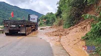
Warning: Flooding occurs in low-lying areas along rivers and urban areas in the Northern region, from Thanh Hoa to Ha Tinh; flash floods and landslides on steep slopes in the mountainous areas of the Northern region, from Thanh Hoa to Ha Tinh. Warning level 3 of natural disaster risk due to floods.
River floods inundate low-lying areas along the river, affecting activities such as waterway transport, aquaculture, agricultural production, people's lives and socio-economic activities.
Source: https://baotintuc.vn/xa-hoi/canh-bao-sap-co-mua-lon-o-noi-thanh-ha-noi-lu-khan-cap-tren-song-thao-20251001104625815.htm


![[Photo] Hanoi morning of October 1: Prolonged flooding, people wade to work](https://vphoto.vietnam.vn/thumb/1200x675/vietnam/resource/IMAGE/2025/10/1/189be28938e3493fa26b2938efa2059e)


![[Photo] Panorama of the cable-stayed bridge, the final bottleneck of the Ben Luc-Long Thanh expressway](https://vphoto.vietnam.vn/thumb/1200x675/vietnam/resource/IMAGE/2025/9/30/391fdf21025541d6b2f092e49a17243f)


Comment (0)