
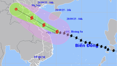
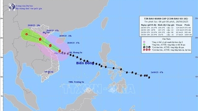
According to the National Center for Hydro-Meteorological Forecasting, at 1:00 p.m. on September 27, the center of the storm was located at about 15.0 degrees North latitude; 114.0 degrees East longitude, about 270 km East Southeast of Hoang Sa special zone. The strongest wind near the center of the storm was level 11-12 (103-133 km/h), gusting to level 15. Moving in the West Northwest direction at a speed of 30-35 km/h,
This is a very fast moving storm (nearly twice the average speed), with strong storm intensity and wide range of influence, which can cause combined impacts of many types of natural disasters such as strong winds, heavy rains, floods, flash floods, landslides and coastal flooding.
At 1:00 a.m. on September 29, the storm was in the sea area of Nghe An - Quang Tri with strong winds of 10-11, gusting to level 14; moving in the West Northwest direction with about 20-25 km/h. The affected areas are the coastal mainland area from Nghe An to the North of Quang Tri with disaster risk level 4; the sea area west of the North East Sea (including Hoang Sa special zone), from Thanh Hoa to Quang Ngai (including Hon Ngu island, Con Co special zone and Ly Son) and the North Gulf of Tonkin (including Bach Long Vy special zone, Van Don, Co To, Cat Hai and Hon Dau island); the mainland area from Ninh Binh to Hue city with disaster risk level 3.
At 1:00 p.m. on September 29, the storm was in the Upper Laos region with winds below level 6; moving in the West Northwest direction at a speed of about 20-25 km/h and gradually weakening into a tropical depression and then a low pressure area. The affected areas are the sea from Thanh Hoa to Da Nang city (including Hon Ngu island, Con Co special zone) and the North Gulf of Tonkin (including Bach Long Vy special zone, Van Don, Co To, Cat Hai and Hon Dau island); the mainland area from Ninh Binh to Hue city.
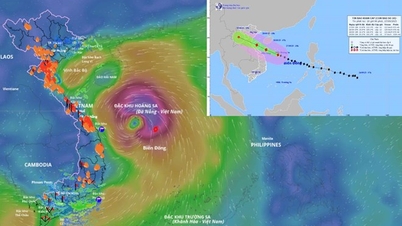
Due to the storm's influence, the North and Central East Sea (including Hoang Sa special zone) have strong winds of level 8-9, the area near the storm's eye has winds of level 10-13, gusts of level 16, waves of 6-8m high, the area near the storm's eye is 8-10m, and the sea is very rough.
From the evening of September 27, the sea area from Thanh Hoa to Quang Ngai (including Hon Ngu island, Con Co special zone and Ly Son) gradually increased the wind to level 6-7, gusting to level 8-9, waves 3-5m high, rough seas. From early morning of September 28, the wind increased to level 8-9, the area near the storm center passed level 10-13, gusting to level 16, waves 5-7m high, rough seas (extremely destructive, extremely strong waves. Sinking large tonnage ships).
From early morning on September 28, in the Northern Gulf of Tonkin (including Bach Long Vi, Van Don, Co To, Cat Hai and Hon Dau islands), the wind gradually increased to level 6-7, then increased to level 8-9 (very rough seas, very dangerous for boats), gusting to level 11, waves 3-5m high, very rough seas.
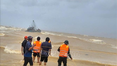
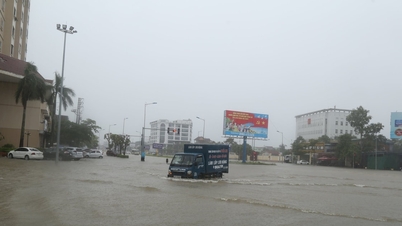
Coastal areas and islands from Ninh Binh - Ha Tinh have storm surges of 0.5 - 1.5m, especially from South Thanh Hoa to North Ha Tinh where they are 1 - 1.5m high. The risk of flooding of dykes, coastal roads, and river mouths due to storm surges and waves is very high on the evening and night of September 28.
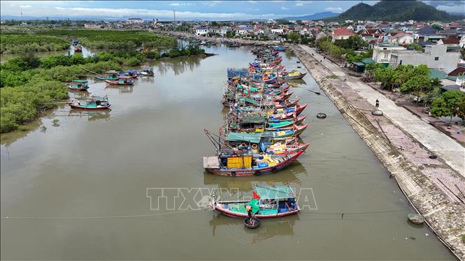
Weather warning at sea, coastal mainland during the storm is extremely dangerous, unsafe for any vehicle or structure operating in the danger zone such as: cruise ships, passenger ships, transport ships, cages, rafts, aquaculture areas, dykes, embankments, coastal routes. Vehicles are highly likely to capsize, be destroyed; flooded due to strong winds, big waves and rising sea levels.
On land, from the afternoon of September 28, on land from Thanh Hoa to Northern Quang Tri, winds gradually increase to level 6-7, then increase to level 8-9, near the storm center, level 10-12 (wind force can knock down trees, houses, electric poles, causing very heavy damage), gusts of level 14; coastal areas from Quang Ninh to Ninh Binh, from Southern Quang Tri to Hue city, winds gradually increase to level 6-7 (trees shake, difficult to go against the wind), gusts of level 8-9.
From the evening of September 27 to 30, in the North and the area from Thanh Hoa to Quang Ngai, there is a possibility of widespread heavy rain with total rainfall ranging from 100-300mm, locally over 450mm; in the Northern Delta, South Phu Tho and from Thanh Hoa to North Quang Tri, it is common to have rainfall from 200-400mm, locally over 600mm.
Source: https://baotintuc.vn/van-de-quan-tam/ven-bien-tu-ninh-binh-ha-tinh-nuoc-dang-cao-tu-05-15m-do-anh-huong-bao-so-10-20250927152850144.htm


![[Photo] Soldiers guard the fire and protect the forest](https://vphoto.vietnam.vn/thumb/1200x675/vietnam/resource/IMAGE/2025/9/27/7cab6a2afcf543558a98f4d87e9aaf95)


Comment (0)