
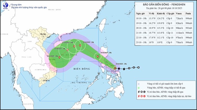
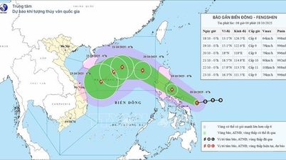
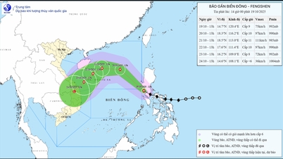
Forecast for the East Sea to welcome storm No. 12 Fengshen in the next 24 hours. Updated location and path of storm Fengshen at 8:00 p.m. on October 18. Source: National Center for Hydro-Meteorological Forecasting
Updated from the National Center for Hydro-Meteorological Forecasting, at 7:00 p.m. on October 18, the center of storm Fengshen was located at about 13.3 degrees north latitude; 124.2 degrees east longitude, in the eastern central region of the Philippines. The strongest wind near the center of the storm was level 8 (62-74 km/h), gusting to level 10. The storm moved west-northwest at a speed of about 20 km/h.
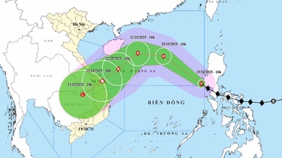
Forecast in the next 24 hours , the storm will move northwest, speed about 20 km/h and is likely to strengthen. At 7:00 p.m. on October 19, the center of the storm will be at about 16.2 degrees north latitude; 119.8 degrees east longitude, in the eastern sea area of the northern East Sea. Strong winds level 9, gusts level 11.
It is forecasted that in the next 48 hours , the storm will continue to move northwest at a speed of 20-25 km/h and may strengthen. At 7:00 p.m. on October 20, the center of the storm will be at about 18.9 degrees north latitude; 115.3 degrees east longitude, in the eastern sea area of the northern East Sea, about 410 km east-northeast of Hoang Sa special zone. Winds will be at level 9-10, gusting to level 13.
The dangerous area in the East Sea in the next 24-48 hours is north of latitude 15.5 degrees north; east of longitude 114.5 degrees east. Natural disaster risk level 3 for the sea area east of the northern East Sea.
It is forecasted that in the next 72 hours , the storm will move mainly westward at a speed of 5-10 km/h and may strengthen. At 7:00 p.m. on October 21, the center of the storm will be at about 18.7 degrees north latitude; 113.8 degrees east longitude, in the northern East Sea, about 270 km northeast of Hoang Sa special zone. Wind force is level 11, gusting to level 13.
The danger zone is north of latitude 16.5 degrees north; east of longitude 112 degrees east. Disaster risk level 3 for the northern East Sea area.
During the next 72 to 120 hours, the storm will move mainly in a southwest direction, about 10 km per hour and then gradually weaken.
Regarding the impact of the storm, from October 19, the sea area east of the northern East Sea will have winds gradually increasing to level 6-7; the area near the storm center will have strong winds of level 8-9, gusting to level 11, waves 2.5-5.0 m high, very rough seas.
During October 20-22, the northern East Sea area (including Hoang Sa special zone) is likely to be affected by strong winds of level 10-11, gusting to level 13. All vessels operating in the above-mentioned dangerous areas are likely to be affected by storms, whirlwinds, strong winds and big waves.
Laodong.vn
Source: https://laodong.vn/moi-truong/bao-fengshen-vao-bac-bien-dong-trong-24-gio-toi-giat-cap-13-trong-ngay-2110-1594114.ldo


Comment (0)