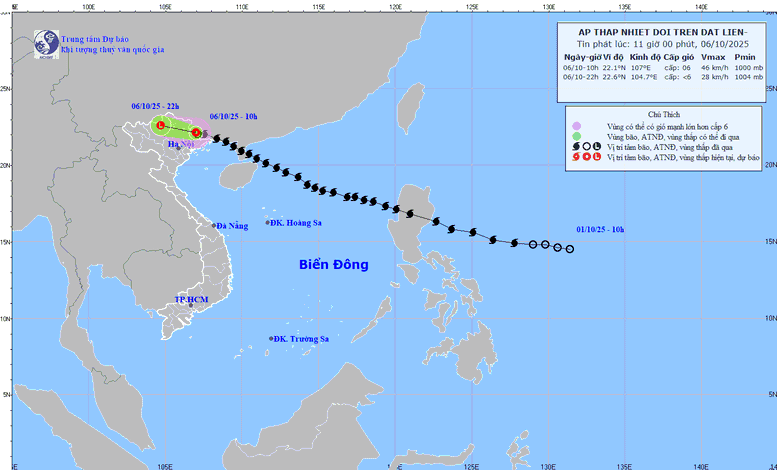
The path of the tropical depression at noon on October 6
According to the National Center for Hydro-Meteorological Forecasting, this morning (October 6), after moving deep into the mainland of Guangxi province (China), storm No. 11 weakened into a tropical depression.
At 10:00 on October 6, the center of the tropical depression was at about 22.1 degrees North latitude; 107.0 degrees East longitude, in the southern area of Guangxi province (China). The strongest wind near the center of the tropical depression was level 6 (39-49 km/h), gusting to level 8. Moving westward, at a speed of about 15 km/h.
This afternoon (October 6), the Northern Gulf of Tonkin area (including Bach Long Vi special zone) has strong winds of level 6, gusts of level 8, waves 2.0-3.0m high, rough seas (dangerous for ships).
On land in Quang Ninh and Lang Son areas, there are strong winds of level 4-5, in some places level 6, gusting to level 7-8.
From October 6 to the night of October 7, in the mountainous and midland areas of the North, there will be heavy rain and thunderstorms, with rainfall ranging from 100-200 mm, and locally heavy rain over 300 mm. Warning of the risk of heavy rain (>150 mm/3 hours) in the Northern Delta and Thanh Hoa; moderate rain, heavy rain with rainfall ranging from 50-100 mm, and locally heavy rain over 200 mm.
Hanoi area: need to be on guard against thunderstorms, tornadoes and strong gusts of wind. Forecast from October 6 to the end of October 7, there will be moderate rain, heavy rain and thunderstorms, with common rainfall of 50-100 mm, locally over 150 mm. During thunderstorms, there is a possibility of tornadoes, lightning and strong gusts of wind.
Warning of the risk of flash floods, landslides, and land subsidence
In the past 2 hours (from 9am to 11am on October 6), Dien Bien province has had moderate to heavy rain such as: Ta Ma 56.6mm, Pu Nhung 52.4mm, Phinh Sang 51mm...
Soil moisture models show that some areas in the province are near saturation (over 85%) or have reached saturation.
In the next 3-6 hours, Dien Bien province will continue to have rain with accumulated rainfall ranging from 30-50mm, in some places over 70mm.
In the next 6 hours, there is a risk of flash floods on small rivers and streams, landslides on steep slopes in the above province, especially in the communes/wards of Muong Mun, Pu Nhung, Sang Nhe; Chieng Sinh, Quai To, Tua Chua, Tuan Giao, Bung Lao, Sinh Phinh, Tua Thang.
Warning level of natural disaster risk due to flash floods, landslides, land subsidence due to rain, floods or water flow: Level 1
Thu Cuc
Source: https://baochinhphu.vn/bao-so-11-suy-yeu-thanh-atnd-canh-bao-mua-cuong-suat-lon-tai-bac-bo-thanh-hoa-102251006120834265.htm













Comment (0)