
According to the National Center for Hydro-Meteorological Forecasting, at 7:00 a.m. on September 25, the center of the storm was at about 21.5 degrees North latitude; 108.9 degrees East longitude, about 100km east of Mong Cai ( Quang Ninh ). The strongest wind near the center of the storm was level 8 (62-74km/h), gusting to level 10. Moving westward, at a speed of about 20km/h.

By 1 p.m. on September 25, the storm was moving west at a speed of about 20 km/h and gradually weakening into a tropical depression. The center of the tropical depression was located at about 21.5 degrees North latitude - 108.0 degrees East longitude, on the mainland northeast of Quang Ninh province. The strongest wind speed was level 6-7, gusting to level 9. Area of influence: north of latitude 20.0 degrees North; west of longitude 110.0 degrees East. Warning of level 3 natural disaster risk for the northern Gulf of Tonkin and the northeastern coast.
At 7:00 p.m. on September 25, the tropical depression continued to move westward at a speed of about 20 km/h and gradually weakened into a low pressure area. The center of the low pressure area was located at about 21.5 degrees North latitude - 107.1 degrees East longitude, on the mainland of the Northeast region of the North. The strongest wind was below level 6.
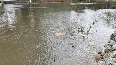
The Northern Gulf of Tonkin area (including Bach Long Vy, Van Don, Co To, Cat Hai and Hon Dau islands) has strong winds of level 6-7, near the storm center of level 8, gusts of level 10, waves 2.0-3.0m high; rough seas.
Ships, boats, and aquaculture areas in the above-mentioned dangerous areas are all strongly affected by strong winds and big waves. Coastal areas from Quang Ninh to Hai Phong have strong winds of level 6, in some places level 7, gusting to level 8-9; inland areas in the Northeast region have strong gusts of level 6-7.
Dr. Nguyen Ngoc Huy, an expert on climate change and natural disaster warning, said that this morning, the center of storm No. 9 is located in mainland China, about 70km northeast of Mong Cai. The strongest wind near the center of the storm is level 8, gusting to level 10.
Thus, storm No. 9 has significantly weakened. From a super storm when entering the 120E meridian area in the North East Sea, when approaching the mainland of Vietnam, it was only level 8-9 due to being blocked by dry and cold air masses.
Storm Bualoi (storm No. 10) is forecast to enter the East Sea from the night of September 26 to the morning of September 27. This could be a strong storm with heavy rainfall. The storm's area of influence is wide because the storm is likely to move along the West - Northwest direction and parallel to the North Central coast.
At 7:00 a.m. on September 25, the center of storm Bualoi was at about 10.8 degrees North latitude; 129.0 degrees East longitude, in the sea east of the Philippines. The strongest wind near the center of the storm was level 12 (118-133 km/h), gusting to level 15. Moving in the West Northwest direction at a speed of 15-20 km/h.
It is forecasted that around the night of September 26, storm Bualoi will enter the eastern sea area of the Central East Sea, becoming storm number 10 in 2025.
At 7:00 a.m. on September 27, the storm moved in a West-Northwest direction at a speed of about 25km/h and entered the East Sea. The center of the storm was located at about 14.7 degrees North latitude - 118.1 degrees East longitude. The strongest wind was level 12, gusting to level 15. Area of influence: from latitude 12.5 to 17.0 degrees North; east of longitude 116.0 degrees East. Level 3 disaster risk warning for the Northeast and Central East Sea.
As of 7:00 a.m. on September 28, the storm continued to move in a West-Northwest direction at a speed of about 25 km/h and was likely to strengthen. The center of the storm was located at about 15.9 degrees North latitude - 112.3 degrees East longitude. The strongest wind was at level 12-13, gusting to level 16. Area of influence: from latitude 13.0 to 18.0 degrees North; east of longitude 110.0 degrees East. Level 3 disaster risk warning for the North and Central East Sea, including the Hoang Sa archipelago.
From the next 72 to 120 hours, the storm will continue to move rapidly in the West-Northwest direction to the Northwest, traveling about 25km per hour, and its intensity will likely increase.
Source: https://baolaocai.vn/bao-so-9-giam-cap-ro-ret-bao-so-10-du-bao-se-manh-len-khi-do-bo-vao-nuoc-ta-post882878.html


![[Photo] President Luong Cuong attends the 80th Anniversary of the Traditional Day of Vietnamese Lawyers](https://vphoto.vietnam.vn/thumb/1200x675/vietnam/resource/IMAGE/2025/10/09/1760026998213_ndo_br_1-jpg.webp)
![[Photo] General Secretary To Lam visits Kieng Sang Kindergarten and the classroom named after Uncle Ho](https://vphoto.vietnam.vn/thumb/1200x675/vietnam/resource/IMAGE/2025/10/09/1760023999336_vna-potal-tong-bi-thu-to-lam-tham-truong-mau-giao-kieng-sang-va-lop-hoc-mang-ten-bac-ho-8328675-277-jpg.webp)
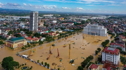
![[Photo] Prime Minister Pham Minh Chinh chairs a meeting of the Government Standing Committee on overcoming the consequences of natural disasters after storm No. 11](https://vphoto.vietnam.vn/thumb/1200x675/vietnam/resource/IMAGE/2025/10/09/1759997894015_dsc-0591-jpg.webp)


Comment (0)