
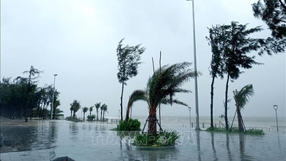
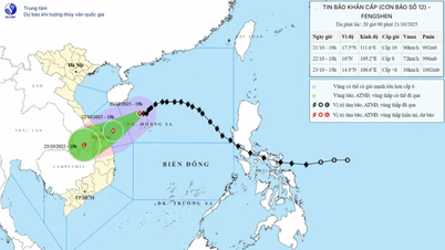
According to the National Center for Hydro-Meteorological Forecasting, at 7:00 p.m. on October 21, the center of the storm was located at about 17.5 degrees North latitude; 111.6 degrees East longitude, in the sea north of Hoang Sa special zone, about 390 km East Northeast of Da Nang city. The strongest wind near the center of the storm was level 9 - 10 (75 - 102 km/h), gusting to level 12. Moving in the West Southwest direction, speed 10 - 15 km/h.
Forecast until 7:00 p.m. on October 22, the storm in the sea area from Hue city to Quang Ngai , strong wind level 8, gust level 10, moving in the West Southwest direction at a speed of about 10 - 15 km/h and gradually weakening. The affected area is the sea area west of the North East Sea (including Hoang Sa special zone), the sea area from South Quang Tri to Quang Ngai (including Con Co special zones, Ly Son and Cu Lao Cham island), level 3 natural disaster risk.
Then, at 7:00 p.m. on October 23, the storm in the Southern Laos area, with winds below level 6, gusts, moved in the West Southwest direction at a speed of about 10 - 15 km/h and was likely to gradually weaken into a tropical depression and then a low pressure area. The affected area is the sea from Quang Tri to Quang Ngai (including the special zones of Con Co, Ly Son and Cu Lao Cham island), the mainland coastal provinces and cities from Quang Tri to Da Nang.
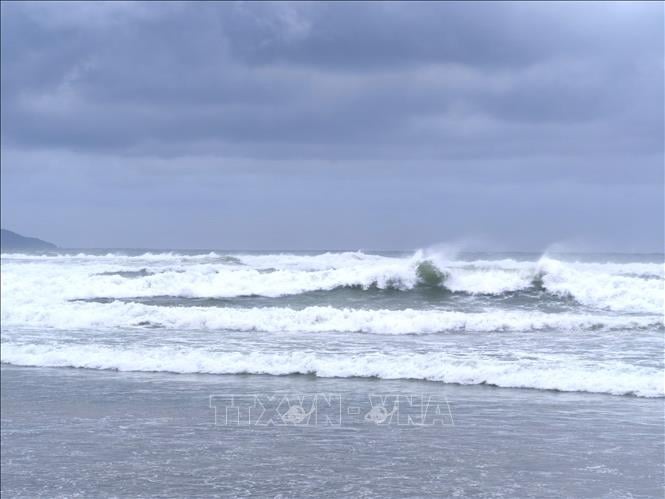
Due to the impact of the storm, the western sea area of the North East Sea (including Hoang Sa special zone) has strong winds of level 7 - 8; the area near the storm's eye has strong winds of level 9 - 10, gusting to level 12; waves 3 - 5m high, the area near the storm's eye has waves of 5 - 7m high, very rough seas.
The sea area from Quang Tri to Quang Ngai (including the special economic zones of Con Co, Ly Son, and Cu Lao Cham islands) has strong winds of level 6, increasing to level 7 from early morning on October 22, the area near the storm's center has level 8, gusts of level 10, waves 3-5m high, rough seas.
Coastal areas from Quang Tri to Da Nang have storm surges of 0.3 - 0.5m high.
Source: https://baotintuc.vn/xa-hoi/bao-tren-vung-bien-tu-hue-den-quang-ngai-se-giam-cap-va-co-kha-nang-suy-yeu-dan-trong-ngay-2210-20251021204613004.htm

![[Photo] Prime Minister Pham Minh Chinh meets with Speaker of the Hungarian National Assembly Kover Laszlo](https://vphoto.vietnam.vn/thumb/1200x675/vietnam/resource/IMAGE/2025/10/20/1760970413415_dsc-8111-jpg.webp)
![[Photo] Prime Minister Pham Minh Chinh received Mr. Yamamoto Ichita, Governor of Gunma Province (Japan)](https://vphoto.vietnam.vn/thumb/1200x675/vietnam/resource/IMAGE/2025/10/21/1761032833411_dsc-8867-jpg.webp)


![[Photo] Da Nang residents "hunt for photos" of big waves at the mouth of the Han River](https://vphoto.vietnam.vn/thumb/1200x675/vietnam/resource/IMAGE/2025/10/21/1761043632309_ndo_br_11-jpg.webp)


Comment (0)