
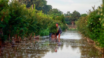
(NLDO) - From morning to noon, Ho Chi Minh City was cloudy, with occasional light sunshine. At around 3 p.m., an unseasonal rain began to fall in districts 1, 5, 8, 10, ...
Accordingly, the rain was light at first, then gradually got heavier, and by 3:30 p.m. on February 15, there was still no sign of stopping.

District 5 rain from about 2:40 pm

At nearly 3 p.m., it started to rain in District 8.

People stopped their cars to wear raincoats.
At more than 2:00 p.m. today (February 15), the Southern Hydrometeorological Station said that thunderstorms are developing and causing rain, thunderstorms, and lightning in the districts of Can Gio, Binh Chanh, Cu Chi, and Binh Tan.
In the next few hours, thunderstorms will continue to develop, causing showers, accompanied by thunderstorms and lightning in the above districts, then expanding to other neighboring areas.
Around 3pm, the rain suddenly became heavier, people stopped their vehicles and put on raincoats.
Rain in District 8
Rainfall is forecast to generally range from 3-10 mm, with some places over 20 mm. During thunderstorms, watch out for tornadoes, hail and strong gusts of wind of about level 5-7 (8-17 m/s), heavy rain causing localized flooding.
According to the forecast, in February, Ho Chi Minh City and other southern provinces and cities will continue to have more rains even though it is the dry season. However, these rains are mainly influenced by the low pressure trough at sea, so there is nothing unusual.
Rain trend in Ho Chi Minh City today
The cold continental high pressure is slowly weakening; the equatorial low pressure trough in the South connects with the low pressure over the sea area off the South Central Coast, weakening and gradually dissipating. Above, the subtropical high pressure across the Central Coast is operating stably.
Source: https://nld.com.vn/chieu-nay-tp-hcm-tiep-tuc-hung-mua-trai-mua-196250215153938704.htm


![[Photo] Binh Trieu 1 Bridge has been completed, raised by 1.1m, and will open to traffic at the end of November.](https://vphoto.vietnam.vn/thumb/1200x675/vietnam/resource/IMAGE/2025/10/2/a6549e2a3b5848a1ba76a1ded6141fae)


Comment (0)