
 |
| Ms. Vu Thi Thu, Director of the Provincial Hydrometeorological Station. |
Reporter (PV): Could you tell us about the formation of storm No. 10, its impact on land and how its circulation affects our province?
Ms. Vu Thi Thu: The National Center for Hydro-Meteorological Forecasting and regional national forecasting stations determined that Storm No. 10 formed in the East Sea from September 27, with the strongest wind near the storm center at level 12 (speed from 118-133 km/h), gusting to level 15. This is a very fast-moving storm (nearly twice the average speed), with strong storm intensity and a wide range of influence, which can cause combined effects of many types of natural disasters such as strong winds, heavy rain, floods, flash floods, landslides and flooding in low-lying areas. In fact, the storm has caused severe damage to people and property in the provinces of the Red River Delta and the North Central region where the storm passed. Not stopping there, after weakening, the storm's circulation caused heavy rain, even very heavy rain in the northern regions, including Tuyen Quang .
PV: So what exactly is the rainfall of the storm circulation in the past few days in the province and the flood discharge mechanism of the hydroelectric reservoir, madam?
Ms. Vu Thi Thu: Due to the influence of storm No. 10, on September 29, 30 and October 1, there was moderate rain, heavy rain and scattered thunderstorms in the province. The common rainfall was 30-70 mm, in some places there was very heavy rain with rainfall over 100 mm such as: Thuan Hoa 130 mm; Ha Giang 1 124 mm; Quang Ngan 124 mm; Viet Lam 122 mm; Cao Bo 120 mm; Phuong Do 110 mm. Some places even had rain over 150 mm, typically: Lao Chai 216 mm; Thu Ta 202 mm; My Lam 190 mm; Truong Sinh 188 mm...
 |
| Phu Lam ward authorities support people to harvest rice to escape the flood. |
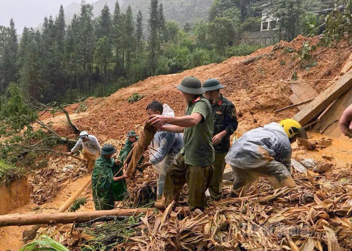
Heavy rains, widespread throughout the region, caused floods in the river and stream systems, in the upstream areas, the water flow to hydroelectric reservoirs was very high. According to the report of Tuyen Quang Hydroelectric Company, at 10:00 a.m. on September 30, at Tuyen Quang Hydroelectric Reservoir, the flow to the reservoir reached 6,900 m3/s. To ensure the safety of the reservoir project, Tuyen Quang Hydroelectric Reservoir had to simultaneously open 8 spillway gates in less than 24 hours - equivalent to 2024, with a total discharge of up to over 5,600 m3/s. At the same time, small hydroelectric reservoirs in the province such as: Bac Me, Song Lo 7, Song Lo 6 and hydroelectric reservoirs such as: Thac Ba ( Lao Cai ), Ma Lu Thang (China) also simultaneously discharged, the water source to the downstream area was very large, causing floodwaters on the Gam and Lo River systems to rise very quickly.
On October 1, the water level of the Lo River in Bac Quang reached 71.58 m; Vinh Tuy 48 m; Ham Yen 33.82 m; Tuyen Quang 25.70 m. On the Gam River in Na Hang 60.95 m; Chiem Hoa 43.79 m; Bac Me 126.08 m are all above the level 2 and level 3 warning levels, which are extremely dangerous. The flood level on the Lo and Gam rivers rose, the strong currents caused flooding in low-lying areas and along the river with a common depth of 2.0 - 4.0 m (upstream of the Lo River and downstream of the Tuyen Quang hydroelectric dam in some places over 5.0 m) and there is a risk of landslides in areas along the river, river banks and beaches, especially in areas with steep slopes and unstable soil structures).
The Provincial Hydrometeorological Station has continuously updated parameters on rainfall, water level, flood discharge information of hydroelectric reservoirs, drafted forecasts, warnings, and situation assessments to serve the leadership and direction of the Provincial Party Committee and Provincial People's Committee and provided them to localities. The Station also updated flood maps, landslide risk areas, and provided timely information to localities to proactively prevent and mitigate damage. 106 communes and wards in flooded and landslide areas have been closely monitored. With continuous and timely updates and the initiative of localities and the experience of people in responding to natural disasters, damage caused by storm circulation has been reduced to the lowest level.
 |
| Chiem Hoa commune authorities support people to overcome the consequences of natural disasters. |
PV: From the above reality, what is your assessment of the weather in the coming days, especially the National Center for Hydro-Meteorological Forecasting predicts a turbulent area, likely to strengthen into a storm, likely to affect the mainland?
Ms. Vu Thi Thu: From October 1 to 2 and in the next 48 hours, areas in the province will continue to have moderate to heavy rain with common rainfall of 20-50 mm, especially in the northern area of the province 30-70 mm, locally over 150 mm. Warning of heavy rain (>70mm/3 hours), beware of the risk of thunderstorms, whirlwinds and strong gusts of wind.
According to leading national and regional weather experts, after storm No. 10-Bualoi, from now until the end of the year there will be 4-5 more storms appearing in the East Sea, with a probability of about 1-2 making landfall. There are currently many disturbances in the Northwest Pacific Ocean, far from the Philippines. These disturbances are the seeds of tropical depressions or storms. There are currently one or two such disturbances, which the meteorological agency is closely monitoring. There is a 50-55% chance that tropical depressions could form in the eastern part of the Philippines over the next week. These systems are likely to move into the East Sea, which could affect our mainland.
In Tuyen Quang, the storm is unlikely to enter, however, the storm's circulation is similar to that of storm No. 3 - Yagi in 2024 and storm No. 10 - Bualoi in the past few days, which is entirely possible, because the weather is very unusual. To ensure the safety of lives, property, and constructions, localities need to proactively and closely monitor forecasts and warnings; be ready with all plans to respond to extreme weather, especially heavy rain, storms, floods, landslides, and rockslides; as soon as there are signs of unusual weather, promptly evacuate people and property to a safe place to minimize damage caused by natural disasters.
PV: Thank you very much!
Performed by: Doan Thu
Source: https://baotuyenquang.com.vn/xa-hoi/202510/chu-dong-moi-tinh-huong-khi-thoi-tiet-dien-bien-bat-thuong-0ac2487/


![[Photo] Prime Minister Pham Minh Chinh chairs the Conference to deploy the National Target Program on Drug Prevention and Control until 2030](https://vphoto.vietnam.vn/thumb/1200x675/vietnam/resource/IMAGE/2025/10/09/1759990393779_dsc-0495-jpg.webp)
![[Photo] Prime Minister Pham Minh Chinh chairs a meeting of the Government Standing Committee on overcoming the consequences of natural disasters after storm No. 11](https://vphoto.vietnam.vn/thumb/1200x675/vietnam/resource/IMAGE/2025/10/09/1759997894015_dsc-0591-jpg.webp)


Comment (0)