

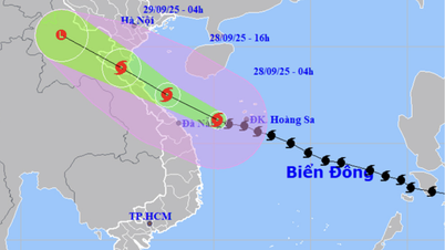
According to the National Center for Hydro-Meteorological Forecasting, at 6:00 a.m. on September 28, the center of storm No. 10 was at about 16.2 degrees North latitude - 109.7 degrees East longitude, about 360km East Southeast of Quang Tri Province, and about 150km East of Da Nang City.
Storm level 12, gust level 15, moving in West Northwest direction, speed about 25km/hour.
Vietnam's Meteorological Agency forecasts that by this afternoon, September 28, the storm's center will be located on the sea area of Nghe An - Quang Tri, with level 12-13 gusts of level 16, likely to strengthen, moving in a West Northwest direction, about 30km/hour.
From tonight to tomorrow morning, September 29, the storm will continue to move in the West-Northwest direction, at a speed of 25-30km/hour, making landfall in the North Central provinces, with the storm center located in Thanh Hoa - Ha Tinh provinces, decreasing to level 9-10, gusting to level 13.
 making landfall tonight, September 28, Vietnam time. Source: Z.E")
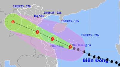
According to the bulletin issued by the US Joint Typhoon Warning Center (JTWC) at 4:00 a.m. on September 28 (Vietnam time), storm Bualoi (called Opong in the Philippines, storm number 20 in Japan, and storm number 10 in Vietnam) is approaching very close to the central region of Vietnam, with very strong winds and dangerous developments.
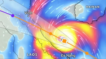
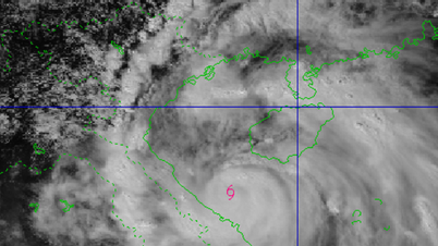
At 4am, the storm center was about 246km east of Da Nang, moving west at 28km/h (slower than 2 days ago but still faster than normal). Waves near the storm center were up to 8.5m high.
It is forecasted that in the next 12 hours, the storm will glide along the Hue - Quang Tri sea area, then make landfall in the North Central region (the storm center may be in the North of Quang Tri province), most likely from the night of September 28 to the early morning of September 29 (earlier than previously forecast).

JTWC said the storm could reach its maximum intensity of 150-165km/h (level 13) when it approaches the central coast of Vietnam. This is a very strong storm, which can cause strong gusts of wind, heavy rain, flash floods, landslides and dangerous water surges in coastal areas.
After moving deep into Vietnam, the storm weakened due to topographic effects and gradually dissipated over northern Laos within 48 hours.
JTWC warned people in the area from Hue to Northern Quang Tri to be especially vigilant against strong winds, heavy rains and the risk of widespread flooding, especially when the storm makes landfall from tonight, September 28.
Source: https://www.sggp.org.vn/dem-nay-28-9-bao-vao-mien-trung-post815140.html


![[Photo] National Assembly Chairman Tran Thanh Man attends the inauguration ceremony of the Memorial Site of National Assembly Standing Committee Chairman Bui Bang Doan](https://vphoto.vietnam.vn/thumb/1200x675/vietnam/resource/IMAGE/2025/9/28/6feba23492d14b03b05445dd9f1dba88)


Comment (0)