

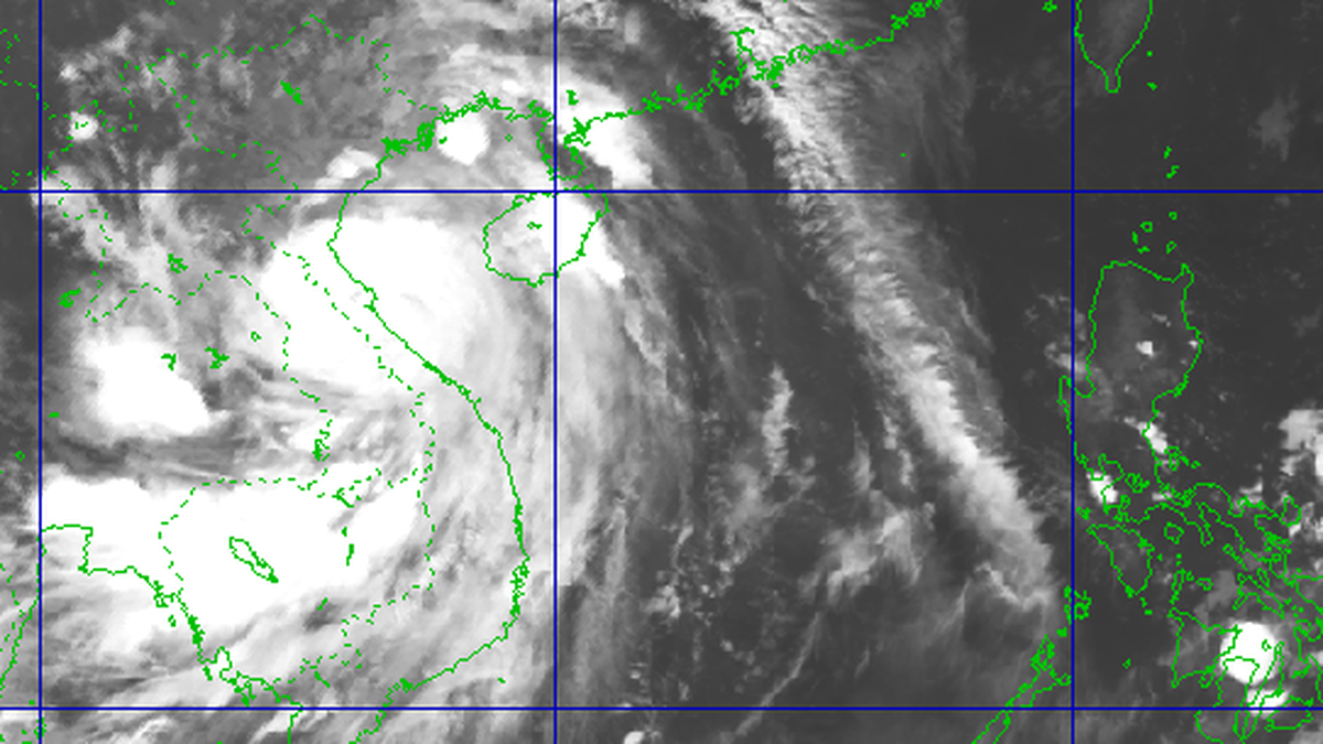
Updated data from the National Center for Hydro-Meteorological Forecasting, at 2:00 p.m. today, September 28, the center of storm No. 10 entered the coordinates of about 17.2 degrees North latitude - 108.1 degrees East longitude, about 90km East Northeast of Hue City, about 165km South Southeast of Northern Quang Tri .
The strongest wind is level 12 (118-133km/h), gusting to level 15. The National Center for Hydro-Meteorological Forecasting predicts that in the next 3 hours, the storm will move in the West-Northwest direction, at a speed of about 20-25km/h, towards the mainland of North Central Vietnam.
Deputy Minister of Agriculture and Environment Nguyen Hoang Hiep said that it is necessary to have the right and sufficient communication method so that people do not become subjective. Because the eye of the storm may hit the area from the former Vinh city of Nghe An province to Northern Quang Tri, but the circulation will affect a wide area and the place with strong (dangerous) gusts of wind may be Thanh Hoa province (located on the northern edge of the storm).
"In storm prevention, the problem is not where the storm center is, but where and when the strongest winds are," Deputy Minister Nguyen Hoang Hiep noted .
According to the Department of Dyke Management and Natural Disaster Prevention, by 4 p.m. this afternoon, September 28, the eye of storm No. 10 will move deep into the sea area of Nghe An - Quang Tri, with a strong intensity of level 12-13, possibly gusting to level 16.
On land from Thanh Hoa to Northern Quang Tri, winds begin to strengthen, from level 6-7 then increase to level 8-9. Areas near the storm center have strong winds of level 10-12, gusting to 14.
According to Mr. Pham Duc Luan, Director of the Department of Dyke Management and Natural Disaster Prevention, the storm's stay on land is estimated to be about 6-8 hours, concentrated from the evening until the end of the night of September 28.
In Quang Tri province, the southern coast has strong winds of level 6-7 from noon to evening. In the north of Quang Tri province, especially the area bordering Deo Ngang, winds reach level 9-11, gusting to 14, lasting from 5 pm to 11 pm today.
 was updated at 2:00 p.m. today according to the JTWC (USA) model.")
Ha Tinh and Nghe An provinces will have winds of level 6-7 from this afternoon, then increase to level 8-9. Coastal areas will have winds of level 10-12, gusting to level 14, lasting from 7pm to 11pm today.
Thanh Hoa from this afternoon will have winds of level 6-7, the southern area of the province will have storm winds of level 8-10, gusts of 13 between 7-11pm today.
Representatives of the Department of Dyke Management and Natural Disaster Prevention also warned that from September 28 to 30, the Northern Delta region, South Phu Tho, Thanh Hoa to North Quang Tri will have 200-400mm of rain, in some places over 600mm.
Other areas will have 100-300mm of rain, locally over 450mm. There is a high risk of flooding in urban and low-lying areas, along with flash floods and landslides on steep slopes.
From September 28 to October 1, many rivers in the North and from Thanh Hoa to Hue experienced floods with peaks reaching alert levels 2-3, in some places exceeding alert level 3, typically on the Thao, Hoang Long, Ma, Chu, Ca, Ngan Sau, Ngan Pho, and Kien Giang rivers.
Source: https://www.sggp.org.vn/mien-trung-de-phong-gio-bao-giat-cap-16-post815208.html
![[Photo] Joy on the new Phong Chau bridge](https://vphoto.vietnam.vn/thumb/1200x675/vietnam/resource/IMAGE/2025/9/28/b00322b29c8043fbb8b6844fdd6c78ea)
![[Photo] High-ranking delegation of the Russian State Duma visits President Ho Chi Minh's Mausoleum](https://vphoto.vietnam.vn/thumb/1200x675/vietnam/resource/IMAGE/2025/9/28/c6dfd505d79b460a93752e48882e8f7e)

![[Photo] The 4th meeting of the Inter-Parliamentary Cooperation Committee between the National Assembly of Vietnam and the State Duma of Russia](https://vphoto.vietnam.vn/thumb/1200x675/vietnam/resource/IMAGE/2025/9/28/9f9e84a38675449aa9c08b391e153183)


Comment (0)